5:06 PM Friday, September 29, 2023
Showers and thunderstorms are likely tonight especially over east central Minnesota and northwest Wisconsin with Duluth and the North Shore possibly on the northern edge of where the highest rain totals setup later tonight.
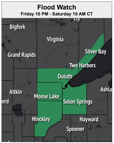
Flooding is possible late tonight through early Saturday morning in parts of east central Minnesota and far northwest Wisconsin due to the possibility of thunderstorms with heavy rainfall moving over the same location for a few hours.
Note — Duluth needs an additional 1.43 inches of rain to tie with 1881 for the wetter September on record. Total rainfall for September 2023 (thru 4 PM Friday) 10.09 inches. Record wettest September 11.52 inches.
A few showers and thunderstorms remain possible Saturday afternoon through Sunday morning over northwest Wisconsin and east central Minnesota as a warm front lifts slowly north out of southern Minnesota. Storms that develop Saturday afternoon through Sunday morning have the chance to produce heavy rain.
NAM 3km model radar forecast through 7 AM Saturday.

RAINFALL FORECASTS
Computer models continue to show the potential for some excessive rainfall amounts tonight into early Saturday morning with areas from east central Minnesota into northwest Wisconsin having the greatest chance for rain totals of 1 to 2 inches with locally higher amounts which could reach 3 or 4 inches.
NWS Blend of Models

NAM 3km model

HREF model

SEVERE THUNDERSTORM POTENTIAL
Isolated strong to severe thunderstorms remain possible tonight over east central Minnesota into far northwest Wisconsin. Large hail to quarter size (1″ diameter) and winds to 60 mph are the primary severe weather threats tonight.

Rainfall Reports from Friday, September 29, 2023 (thru 4 PM)
Source: MesoWest
Orr, MN: 0.74″
Bigfork, MN: 0.71″
International Falls, MN: 0.66″
Cass Lake, MN: 0.61″
McGregor, MN: 0.60″
Hill City, MN: 0.57″
Grand Rapids, MN: 0.43″
Brainerd, MN: 0.37″
Walker, MN: 0.36″
Hibbing, MN: 0.30″
Hayward, WI: 0.20″
Clam Lake, WI: 0.16″
Moose Lake, MN: 0.16″
Siren, WI: 0.15″
Ely, MN: 0.14″
Saginaw, MN: 0.12″
Minong, WI: 0.12″
Esko, MN: 0.07″
Ashland, WI: 0.04″
Duluth Airport: 0.03″
Duluth Sky Harbor Airport: 0.03″
Solon Springs, WI: 0.03″
Superior Airport: 0.02″
FOG POSSIBLE NEAR LAKE SUPERIOR THIS WEEKEND
A humid onshore flow coming off Lake Superior combined with a strong temperature contrast setting up across the region could lead to times of fog and low clouds near Lake Superior Saturday and Sunday, and some of this fog could become dense at times with visibilities <1 mile.
Temperatures Saturday afternoon are forecast to range from the mid 50s to mid 60s near Lake Superior to around 90 in southern Minnesota.
Warmer temperatures will spread farther north into the Northland Sunday with highs in the mid 70s to low-mid 80s.
This warmth will finally reach areas near Lake Superior but not until Monday, that’s when we could see temperatures of 80 or warmer occur.

COOLER RISKS LATE NEXT WEEK
Computer models are showing an upper-level trough digging S/SE into the upper Midwest and Great Lakes late next week, and this trough could be a strong one and may usher in at least a brief period of much cooler temperatures sometime around October 6-9 with a chance for high temperatures only in the 40s and 50s in the Northland next weekend.

Thanks for reading!
Tim
Leave a Reply