4:55 PM Sunday, October 8, 2023
A chilly night ahead of us as long as the clouds move away which isn’t a guarantee.
If skies do become mostly clear tonight, then will see temperatures drop into the 20s to lower 30s across the entire Northland with slightly warmer temperatures close to Lake Superior.
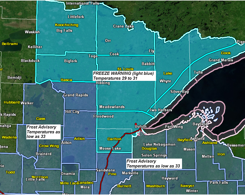
A freeze warning is in effect for parts of northeast Minnesota from 1 AM to 9 AM Monday with a frost advisory in effect for all of northwest Wisconsin and for east central Minnesota also from 1 AM to 9 AM Monday.

We are seeing some clearing in far northeast Minnesota late this afternoon otherwise skies are fairly overcast across the rest of northeast Minnesota and northwest Wisconsin late today.
Goes-16 visible satellite loop from Sunday, October 8, 2023 (loop time ends 4:01 PM CT)

We’ve also seen a few rain showers move south today across parts of northeast Minnesota and northwest Wisconsin; these showers should diminish by late tonight.
Radar loop ending 4:10 PM CT, Sunday, October 8, 2023.

Pattern this week will feature a strong upper level low/trough across southeast Canada into the northeast U.S., with an upper-level ridge west of Hudson Bay Canada. It’ll be a cool week across the Northland with this type of upper-level pattern with highs mostly in the upper 40s to middle 50s with lows in the 30s and 40s with some 20s on nights that see some clearing.
Also of interest will be an area of low pressure that develops over Colorado or somewhere close to Colorado by midweek.

It does look like will see our first low of the season come out of Colorado this week, but the track of this system is handled differently by the computer models.
The farther north this system tracks the greater the rain chances will be in the Northland, while a farther south storm track would lead to lower chances for rain in much of the northland.
There is also a chance that we could see some strong northeast winds near Lake Superior later this week depending on the track of this system.

The Euro and Canadian models have this late week system tracking much farther north which leads to some heavy rainfall amounts in all of northwest Wisconsin, and also in east central Minnesota and along the North Shore of Lake Superior.


A much farther south storm track is seen in the GFS/GEFS models today which leads to lesser amounts of rain and a lesser risk for heavy rainfall in northeast Minnesota and northwest Wisconsin.

The NWS Blend of Models is giving more weight toward the GEFS/GFS camp vs. the Euro and Canadian models today.

One thing does look pretty certain at the moment and it’s that temperatures do look warm enough for rain to be the main precipitation type in the Northland should that late week system track far enough to the north to bring precipitation to our area.
This week’s system should have a snowy side to it, but right now it looks like all of that snow would be over western South Dakota, western Nebraska into parts of Wyoming and Colorado.

Thanks for reading!
Tim
Leave a Reply