6:10 PM Tuesday, October 31, 2023
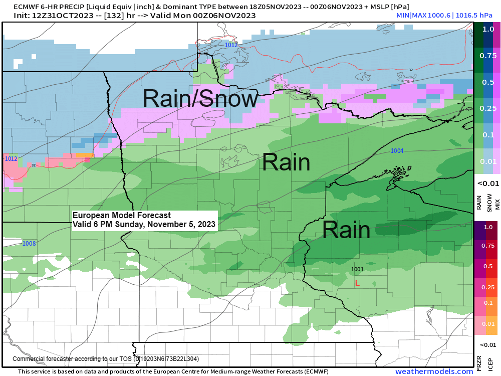
The next few days look mainly dry across the Northland, but chances for some precipitation return sometime this weekend into early next week. Currently it looks like temperatures will be warm enough for precipitation to be in the form of rain with this next system this weekend into early next week, but a rain/snow mix is possible in far northern Minnesota. Note — Timing, temperatures and the track of this system could change over the next few days.
The first snow event of the 2023-2024 season occurred in much of the Northland Monday night into Tuesday morning with a general 1 to 3 inch snowfall, but there were exceptions mixed in with higher snowfall totals of 5 to 8 inches reported along the North Shore of Lake Superior in northeast Minnesota generally from north of Two Harbors to the Silver Bay area, and also in parts of northwest Wisconsin (South Shore area)
*Official snowfall total at the National Weather Service in Duluth for last night’s event was 1.5 inches with a precipitation total of 0.05″ which leads to a snowfall ratio of a very high 30:1 for this event, typically our snowfall ratio is around 12:1.
*Snowfall total in Duluth for October 2023 will finish at 1.7 inches which is -1.0 inch below normal and is 63% of our normal snowfall for October. Note — Last October Duluth recorded 5.1 inches of snow.
*Total precipitation in Duluth for October 2023 will finish at 1.50 inches which is -1.41 inches below normal and is ~50% of our normal precipitation for October.
*Note — Monthly average temperatures for October 2023 will end up around +1.5 degrees to around 3 degrees above average at the 4 main climate stations across the Northland (Ashland, Brainerd, Duluth and Hibbing)
Another cold night ahead of us with widespread temperatures in the teens to lower 20s in northeast Minnesota and northwest Wisconsin with a few single digits even possible in the typical cold spots.

Here’s a look at the GEFS model precipitation type forecast valid for next Monday, November 6, 2023.
A lot of uncertainty with this next system but that is pretty typical for a system about 5 days out.
Blue colors=Snow
Green colors=Rain
As you can see, some ensemble members show snow for Duluth, others rain, while a few others keep us dry.

Snowfall Reports from Monday evening-Tuesday, October 30-31, 2023
Source: National Weather Service Duluth, Minnesota
Two Harbors, MN 7 NNW: 8.4″
Wolf Ridge, MN: 7.2″
Solon Springs, WI 1 W: 6.9″
Finland, MN 3 E: 6.5″
Wales, MN 7 NNE: 6.5″
Delta, WI 4 WNW: 6.0″
Washburn, WI 4 WNW: 6.0″
Silver Bay, MN 1 NE: 6.0″
Grand View, WI 6 E: 5.7″
Iron River, WI 4 E: 5.5″
Finland, MN: 5.0″
Sanborn, WI 4 SSE: 5.0″
Brimson, MN 2 S: 4.4″
Maple, WI 1 WSW: 4.4″
Pine City, MN 1 SSW: 4.1″
Sandstone, MN: 4.0″
Blueberry, WI: 4.0″
Port Wing, WI: 3.7″
Deer River, MN 3.7 W: 3.6″
Cornucopia, WI 3 S: 3.5″
Lake Nebagamon, WI 1 N: 3.3″
Grantsburg, WI 0.6 SW: 3.3″
Ely, MN 1 WNW: 3.2″
Superior, WI 1 SSW: 3.0″
Rock Creek, MN 6 E: 3.0″
Orr, MN 3 E: 2.8″
Holyoke, MN 3 ENE: 2.8″
Brookston, MN: 2.6″
Deer River, MN 7 NE: 2.5″
Cook, MN: 2.4″
Floodwood, MN 2 ESE: 2.2″
Iron Junction, MN 3 S: 2.0″
Trade Lake, WI 2 N: 1.8″
Lester Park, MN 3 SW: 1.8″
McGregor, MN 7 N: 1.8″
Grand Rapids, MN 7 SSW: 1.6″
Fond Du Lac, MN 2 NNE: 1.5″
Two Harbors, MN 1 SSE: 1.5″
Gary New Duluth, MN 1 N: 1.5″
Baxter, MN 1 NW: 1.5″
Federal Dam, MN 0.3 S: 1.5″
Embarrass, MN: 1.4″
Sarona, WI 5 E: 1.3″
Finlayson, MN 5 WNW: 1.2″
Cohasset, MN 2 ENE: 1.1″
International Falls, MN 5 SSW: 1.0″
Pillager, MN 5.1 N: 1.0″
Brainerd, MN 7.7 SSE: 1.0″
Cloquet, MN 1 NNE: 0.9″
Cold pattern continues!

Goes-16 water vapor loop from Tuesday, October 31, 2023 (loop time ends 5:10 PM CT)

TEMPERATURE TRENDS FOR NEXT WEEK
Below average temperatures look like they will continue in the Northland right into next week.

GEFS model temperature anomaly trend for November 6-11, 2023.
Oldest model run is Days 9-13 on the loop below and the newest model run is Days 7-11.
Below average temps (blues)
Above average temps (oranges)

Thanks for reading!
Tim
Leave a Reply