6:22 PM Monday, November 6, 2023
Active weather pattern the next few days.
-Lingering scattered snow or rain showers tonight (mainly before Midnight)
-A little lake effect snow or rain late tonight along the South Shore of Lake Superior in northwest Wisconsin, shifting to the North Shore in northeastern Minnesota Tuesday as winds become easterly. Snowfall accumulations <1″ near Lake Superior late tonight and Tuesday.
-Some rain and snow at times in the Northland Tuesday afternoon into early Wednesday morning.
-Scattered snow showers or mixed rain/snow showers late Wednesday through Friday. Up to 1″ of snow possible in some locations in the Northland Wednesday night through Thursday.
-Breezy conditions will continue the next few days with northwest winds tonight shifting out of the east to southeast Tuesday then shifting southerly Wednesday and westerly Thursday. Wind gusts of 15 to 30 mph are expected at times over the next few days.
North Shore of Lake Superior especially in the higher terrain could see around 1 to 3 inches of snow late Tuesday afternoon into early Wednesday morning.
Duluth area: Less than 1″ of snow Tuesday and Tuesday night with any snow accumulation mostly on top of the hill in Duluth. No snow accumulation expected in lower elevation closer to Lake Superior.

This next system shouldn’t produce as much precipitation compared to the previous system Sunday night.
Total precipitation amounts ranging from around 0.10″ to 0.25″ are forecast in parts of northeast Minnesota and far northern Wisconsin with higher amounts approaching 0.50″ possible along the North Shore of Lake Superior. Lesser amounts of precipitation farther south including for Brainerd, Aitkin, Hinckley and Spooner areas.

NAM 3km model radar forecast valid from Midnight tonight to 6 AM Wednesday.
Snow (blue)
Rain (green)
Wintry Mix (purple)

24-Hour Precipitation Reports from 11/5-11/6/2023 (thru 5:32 PM on the 6th)
Source: MesoWest
Hermantown, MN: 1.01″
Saginaw, MN: 0.90″
Grand Marais, MN: 0.90″
Duluth Airport: 0.86″
French River, MN: 0.82″
Schroeder, MN: 0.81″
Cook, MN: 0.76″
Isabella, MN: 0.74″
Esko, MN: 0.74″
Orr, MN: 0.73″
Ely, MN: 0.72″
Two Harbors, MN: 0.69″
Duluth Sky Harbor Airport: 0.66″
Littlefork, MN: 0.65″
McGregor, MN: 0.60″
Eveleth-Virginia, MN: 0.58″
International Falls, MN: 0.58″
Superior Airport: 0.52″
Hibbing, MN: 0.52″
Brainerd, MN: 0.49″
Hill City, MN: 0.40″
Poplar, WI: 0.40″
Washburn, WI: 0.37″
Bigfork, MN: 0.30″
Moose Lake, MN: 0.27″
Grand Rapids, MN: 0.25″
Deer River, MN: 0.25″
Glidden, WI: 0.22″
Ashland, WI: 0.17″
Clam Lake, WI: 0.17″
Northome, MN: 0.16″
Hayward, WI: 0.15″
Solon Springs, WI: 0.12″
Cable, WI: 0.10″
Minong, WI: 0.08″
Walker, MN: 0.05″
Cass Lake, MN: 0.04″
Spooner, WI: 0.04″
Siren, WI: 0.03″
Webb Lake, WI: 0.03″
Colder air has moved into the Northland today behind an area of low pressure which is located east of Lake Superior early this evening. Lingering moisture behind this system combined with the colder temperatures caused the rain to turn to snow in far northern Minnesota and Arrowhead today while temperatures remained warm enough for mostly rain farther south today.

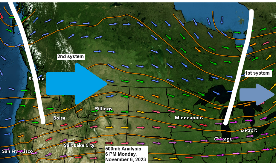
The system which brought rain to the Northland Sunday night and rain or snow to parts of the area today continues to move farther off to the east and away from the Northland late this afternoon.
Goes-16 water vapor loop from Monday, November 6, 2023 (loop time ends 4:40 PM CT)

But upstream is our next system which will affect the Northland beginning Tuesday afternoon with some lingering effects all the way through Thursday or Friday as upper level low and trough dig southeast out of central Canada and into the upper Midwest and upper Great Lakes region.
Goes-16 water vapor loop from Monday, November 6, 2023 (loop time ends 4:50 PM CT)

Next week is looking pretty mild across the Northland thanks to an upper-level ridge and SW flow aloft which is forecast to develop while a trough sets up across the western U.S.

A few days next week could have temperatures during the afternoon reaching or exceeding 50 degrees in the Northland.

Thanks for reading!
Tim
Leave a Reply