6:25 PM Tuesday, November 28, 2023
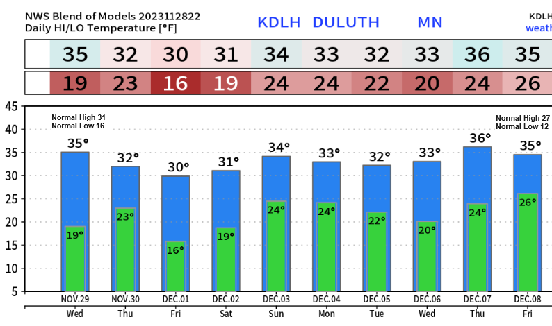
Warmer temperatures are on the way for the next several days. Afternoon temperatures at or above the freezing mark are expected in the Twin Ports starting tomorrow (Wednesday) and lingering through much of next week with overnight/morning temperatures mainly in the middle 10s to middle 20s. Note — It’s possible will see a few days between tomorrow (Wednesday) and late next week with afternoon temps nearing 40 in Duluth.
Still no signs of any major winter storms impacting the Northland through late next week or through December 8th, in fact it doesn’t look like will be getting a whole lot of precipitation in our area over the next 5 to 7 days or more with any precipitation that we do get mostly on the light side with very little impact to travel the way it looks now.
Here’s a look at some cities which have had more snow this month compared to what we’ve seen in Duluth this month which is just 1.3″ of snow.
Topeka, KS: 7.2″
Dodge City, KS: 5.3″
Des Moines, IA: 2.6″
Madison, WI: 2.5″
Detroit, MI: 2.2″
Waterloo, IA: 2.1″
Chicago, IL: 1.8″
*The first subzero temperature of the season occurred in Duluth this morning, Tuesday, November 28, 2023, with a low of -2 degrees. The average date for the first subzero temperature in Duluth is December 2nd. Last year’s first subzero temperature occurred on December 3rd.
*Earliest first subzero temperature on record for Duluth is November 2nd (1951) and the latest first subzero temperature on record for Duluth is January 11th (1914).
Low Temperature Reports from Tuesday morning, November 28, 2023
Source: National Weather Service Duluth, Minnesota
Celina, MN 2E: -11
Cotton, MN: -9
Cook, MN: -9
Orr, MN: -8
Hibbing, MN: -8
Brimson, MN: -7
International Falls, MN: -6
Embarrass, MN: -6
Floodwood, MN: -6
Siren, WI: -5
Eveleth, MN: -4
Bigfork, MN: -4
Tower, MN 2S: -3
Hayward, WI: -3
Clam Lake, WI 4W: -2
Duluth Airport: -2
Grand Rapids, MN: -2
Cloquet, MN: -2
Walker, MN: -2
Cass Lake, MN: -2
Two Harbors, MN: 0
Grand Marais Airport: 0
Longville, MN: 0
Pine River, MN: 0
Moose Lake, MN: 0
Solon Springs, WI: 0
Aitkin, MN: 1
Brainerd, MN: 1
Crane Lake, MN: 1
Superior, WI: 2
McGregor, MN: 3
Ashland, WI: 5
Duluth Sky Harbor Airport: 5
Ely, MN: 5
NEXT WEEK’S PATTERN
The pattern for next week is forecast to feature two main troughs, one over the northeast U.S. into the Atlantic Ocean with another trough over far western Canada into the Pacific northwest. In between the two troughs a ridge is forecast to develop, and that ridge looks to keep the weather pretty quiet in the Northland for much of next week.

Here’s the snowfall forecast all the way through December 8th, 2023.
Not a whole lot of snow ahead, and what’s shown on the map well most of that comes Sunday-early Monday when we could see a trace to 1″ of snow in parts of the Northland.

Where’s all the snow been lately? Well, let’s take a look.
This past weekend was rather snowy across portions of the central Plains mainly from southern to east central Kansas extending into northern Missouri, parts of Iowa and northern Illinois.

And then of course we have the lake effect snow machine off the Great Lakes over the last few days thanks to all the cold air moving over the warmer waters of the Great Lakes.
Those highlighted areas on the map below represents where we’ve seen snowfall amounts >12″.

Upper Michigan has also seen quite a bit of lake effect snow the last few days.

Thanks for reading!
Tim
Leave a Reply