4:13 PM Sunday, December 3, 2023
Outside of a few flurries and light snow showers tonight through Monday night the week ahead looks pretty quiet across the Northland.
With a mild and mostly snowless pattern ahead, it’s never too early to look at what the top 5 least snowy Decembers and top 5 warmest Decembers on record are at Duluth, Minnesota.
Will December 2023 make a run at a top 5 least snowy and warmest December on record, time will tell.
Top 5 least snowy Decembers on record for Duluth, Minnesota.
Note — Average snowfall for December is 18.7″
1: 0.9″ set in 1905
2: 1.1″ set in 1894
3: 1.2″ set in 1892
4: 1.3″ set in 1939
5: 1.8″ set in 1952
Top 5 warmest Decembers on record for Duluth, Minnesota.
Note — Average temperature for December is 17.1 degrees
1: 32.7 degrees set in 1877
2: 26.9 degrees set in 1891
3: 26.7 degrees set in 1931 and also in 1913
4: 26.5 degrees set in 1939
5: 26.4 degrees set in 2015
A pretty strong upper-level low and upper-level trough is swinging ENE across the eastern Great Lakes today. This system is bringing some snow to parts of Wisconsin into upper Michigan and northern Lower Michigan today with rain farther to the south/east with even a few thunderstorms today in parts of western New York and Pennsylvania.
Goes-16 water vapor loop from Sunday, December 3, 2023 (loop time ends 2:41 PM CT)

Parts of southern, central and eastern Wisconsin saw some snow today with accumulations generally in 1-to-3-inch range. Snow is pulling away from northeast Wisconsin late this afternoon with the steadiest snow covering northern Lower Michigan and central/eastern portions of upper Michigan late this afternoon.

It doesn’t look like will be dealing with any arctic air (subzero temps) in the Northland for about the next 2 weeks.
Note — For the most part we’re looking at afternoon temps in the Northland mostly in the 30s this week with a few 40s possible on a few afternoons, with overnight/morning temps in the teens and 20s with a few nights with temps holding around 30.
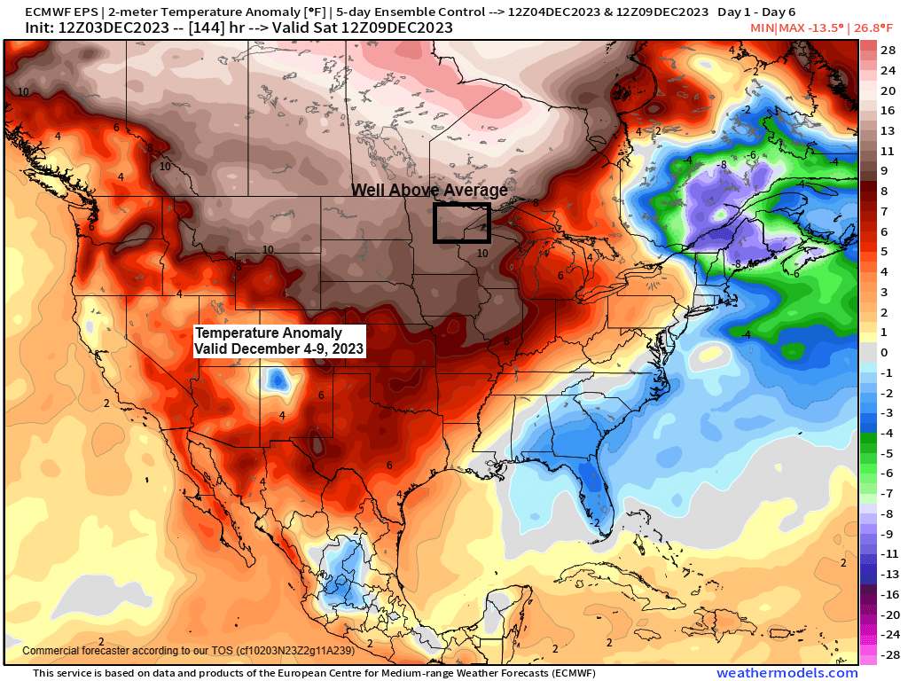
EPS model temperature anomaly forecast for December 4-9, 2023.

GEFS model temperature anomaly trend for December 4-9, 2023.
Oldest model run is days 4-8 on the loop below and the newest model run is days 2-6.
Orange and reds: Above average
Blues: Below average

An early look at temperature trends for next week shows more of the same across our area but colder risks (blue and green colors on the map) are showing up across parts of the southern/central U.S. to the Ohio Valley next week.
EPS model temperature anomaly forecast for December 11-16, 2023.

Here’s the 15-Day snowfall forecast (through December 18, 2023) for Duluth from the EPS model.
There’s only 3 out of 50 EPS members showing major snowfall totals (10″+ totals) in Duluth through December 18, so the chances of that happening are very low at 6%.

Here’s the 20 member GEFS model snowfall forecast through Monday, December 11, 2023.
4/20 GEFS members show around 2″ or more of snow in Duluth through December 11, so once again low odds at 20%.

And finally, here’s the NWS Blend of Models snowfall forecast through next Monday.

Thanks for reading!
Tim
Leave a Reply