6:00 PM Monday, December 4, 2023
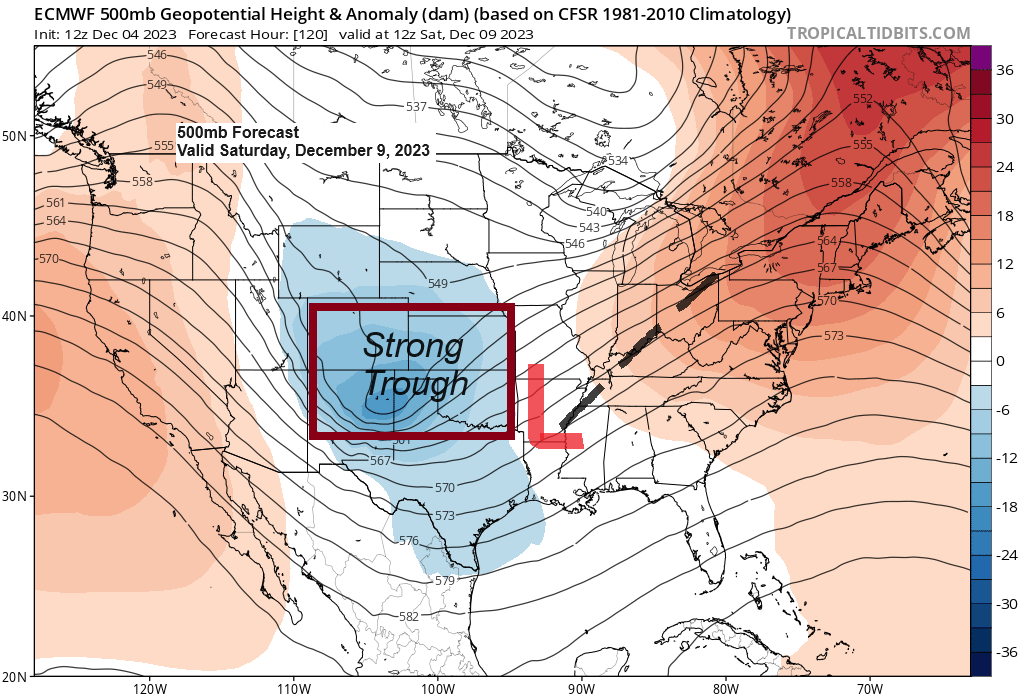
A strong upper-level trough is forecast to dig southeast into the southern Plains on Saturday while an area of low pressure develops ahead of this upper trough. This system could become quite strong as it lifts northeastward to the Ohio Valley/eastern Great Lakes region from Sunday into next Monday.
Severe thunderstorms including a risk for large hail, damaging winds and a few tornadoes could develop on Saturday in the warmer air in parts of east Texas, northwest Louisiana into much of Arkansas, while snow is possible in the colder air farther to the north, and there is a potential for a significant winter storm (strong winds + heavy snow ) to develop sometime in the Saturday night to Monday morning time frame in parts of the Midwest to eastern Great Lakes region, and this could include cities such as St. Louis, Champaign, Terre Haute, Lafayette, South Bend and possibly Chicago, Detroit and even Indianapolis.
Note — There is no threat for this storm to impact northeast Minnesota or northwest Wisconsin this weekend.
Saturday’s Severe Weather Outlook
Yellow=Slight risk or a level 2/5 for severe thunderstorms.

Areas in red on the map could see snowfall totals of 2-5″+ Saturday night-Monday morning.

A clipper system is moving southeast across the Northland this evening and this system is producing a little snow and a wintry mix in parts of east central Minnesota and northwest Wisconsin. This snow or a wintry mix will linger through this evening before ending late tonight.
Note — Snowfall accumulations of a trace to 1″ are possible tonight in parts of east central Minnesota and northwest Wisconsin, and with temps in the upper 20s and lower 30s, we could see some slick spots develop on the roads, but otherwise no major impacts are expected tonight.

NW flow aloft is in place across the region today while a clipper drops southeast through the area.
Goes-16 water vapor loop from Monday, December 4, 2023 (loop time ends 5:20 PM CT)

A lot of warm air will be pushing east into the upper Midwest for Wednesday and Thursday with 850mb temperatures increasing to between +6 and +14C which is very mild for this time of the year.
If we get enough mixing and enough sunshine, then temperatures for Wednesday afternoon and Thursday afternoon should climb into the 40s in much of the Northland with Thursday looking like the warmer of the two days.

Next week’s temperature trends per the EPS and GEFS models continue to point towards above average temperatures in northeast Minnesota and northwest Wisconsin.
EPS model temperature anomaly forecast for December 11-16, 2023.

GEFS model temperature anomaly trend for December 11-16, 2023.
Oldest model run is days 10-14 on the loop below and the newest model run is day 8-12.
Orange and red colors: Above average temps
Blue colors: Below average temps

Thanks for reading!
Tim
Leave a Reply