6:05 PM Friday, January 19, 2024
One more very cold night ahead of us as temperatures fall to around 5 below to 20 below zero in the Northland with a chance for temperatures as cold as 25 below in a few locations in northern Minnesota.
Highs on Saturday will range from around 8 to 14 degrees with lows Saturday night ranging from around 5 below to 5 above zero.
It still looks like will see high temperatures at or above the freezing mark in much of the Northland by the middle of next week and through next weekend.
There is a chance for a little snow mainly in far northern Minnesota early next week, but for the most part next week is looking pretty dry at the moment.
Low Temperature Reports from Friday morning
Source: National Weather Service Duluth, Minnesota
Ash Lake, MN: -24
Nashwauk, MN: -20
Cook, MN: -20
Togo, MN: -18
Ely, MN: -18
Orr, MN: -17
International Falls, MN: -17
Deer River, MN: -16
Grand Marais, MN: -16
Northome, MN: -15
Hill City, MN: -15
Bigfork, MN: -15
Eveleth, MN: -14
Grand Rapids, MN: -14
Hibbing, MN: -14
Longville, MN: -13
Cotton, MN: -10
Duluth Airport: -9
Solon Springs, WI: -8
Webb Lake, WI: -8
Aitkin, MN: -8
Brainerd, MN: -8
Spooner, WI: -7
Superior Airport: -7
Two Harbors, MN: -6
Cable, WI: -6
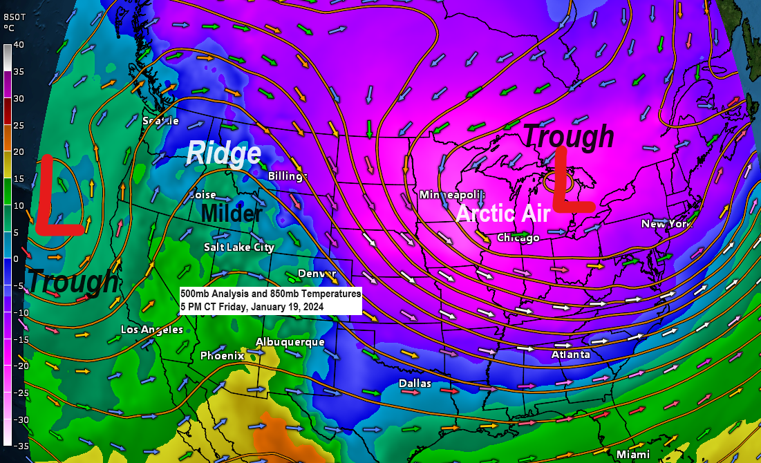
Quite a pattern change will occur next week as we get rid of the cold upper-level trough that we’ve seen for a better part of a week and replace it with higher 500mb heights and an upper-level ridge over the eastern U.S.

The pattern could change a bit especially over the eastern U.S. toward the last few days of this month and into early February but here in the Northland it looks like will keep higher 500mb heights around with a ridge off to our west.

Temperatures will respond to this pattern change with widespread well above normal temperatures expected in the Northland from January 22 through February 2.
Keep in mind that above normal temperatures at this time of year would likely consist of highs in the 30s with lows in the teens and 20s in our area.


We do have a chance for a little snow Sunday night into Monday mainly across northern Minnesota (best chances north of Duluth).
European model simulated radar forecast valid 6 PM Sunday to 6 PM Monday.

Up to an inch of snow is possible Sunday night-Monday in far northern Minnesota (black outlined area on map).

Looking even further out shows that the prospects for seeing quite a bit of snow in the Northland are quite low for the rest of this month.
Here’s the 20-member GEFS model total snowfall forecast through January 31.
Purple colors represent snowfall totals of 6 or more inches, and there isn’t any member that shows that much snow in Duluth through the end of the month.

And the EPS model 50-member snowfall forecast for Duluth shows the same in that there isn’t a whole lot of snow in our future looking out the next 2 weeks or so.
Snowfall total for the rest of this month in Duluth according to the EPS model ranges from a low-end amount of 0.3 inches to a high-end amount of 4.0 inches, but there’s only 4 out of 50 members which show 4 inches of snow in Duluth through January 31, so pretty low odds for that to actually happen.

Thanks for reading!
Tim
Leave a Reply