6:06 PM Thursday, February 1, 2024
Cooler temperatures moved into the Northland today especially near Lake Superior where increasing northeast winds caused temperatures to drop into the upper 20s to low to mid 30s this afternoon but believe it or not this is still above normal for this time of the year.
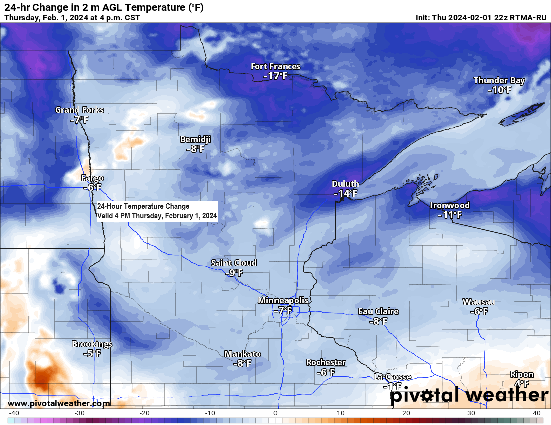
Temperatures this afternoon near Lake Superior and also in far northern Minnesota were running about -15 degrees cooler compared to the temperatures we saw Wednesday afternoon.
- 17.1 inches of snow so far this season in Duluth. Normal snowfall to date is 52.9 inches. A snowfall deficit of -35.8 inches below normal to date.
- Snow depth down to 2 inches in Duluth (NWS location, on top of the hill)
- <5% of Lake Superior covered by ice as of January 31st. Average is around 25% ice coverage at this time of the year.
A strong upper-level ridge covered the northern Plains today with a deep trough over the western U.S., while another trough covered eastern Canada today. This pattern won’t be changing much over the next several days.

Here’s how the pattern looks via water vapor imagery today. Loop time ends 5:10 PM CT.

An active/wet pattern into early next week from the western U.S. into the central and southern U.S., while it looks mainly dry in the upper Midwest and Great Lakes through early next week.

It continues to look like will see some sort of pattern change occur mid to late next week as will finally get rid of the strong ridge near our area and replace it with a trough which moves east out of the Rockies.
The issue with any system which affects the Northland mid to late next week is that it looks like there won’t be much cold air around so a lot of the precipitation that we may see could fall as rain with only minimal amounts of snow the way it looks now.

There is plenty of arctic air lurking around stretching from much of Alaska into far northern Canada with temperatures in the teens and 20s below zero with even some locations as cold as the 30s and 40s below today. Note: This arctic air won’t be affecting the Northland anytime soon as winds in the upper levels of the atmosphere are not in a favorable direction to push this arctic air farther south into our area.

Still no signs of temperatures returning to normal in Duluth at least for the next 10 days.
Looks like will have a few days in a row with highs of 40 or warmer in Duluth from Sunday through about the middle of next week.

Here’s the 30 member GEFS model 500mb height anomaly forecast for Duluth through February 17th.
Orange, red and white colors on the image below represents higher 500mb heights and milder temperatures while blue and green colors represent lower 500mb heights and cooler temperatures.
As you can see on the image below, we may be waiting until around mid-February for lower 500mb heights to return along with a chance for some colder temperatures in Duluth.

High Temperature Reports from Wednesday, January 31, 2024
Source: National Weather Service Duluth, Minnesota
Pine River, MN: 55
Walker, MN: 55
Crane Lake, MN: 54
Bigfork, MN: 54
International Falls, MN: 53
Brainerd, MN: 53
Cass Lake, MN: 53
Orr, MN: 52
Longville, MN: 52
Aitkin, MN: 52
Moose Lake, MN: 52
Cloquet, MN: 52
McGregor, MN: 52
Floodwood, MN: 52
Hibbing, MN: 50
Cook, MN: 50
Grand Rapids, MN: 50
Hinckley, MN: 50
Siren, WI: 50
Cotton, MN: 50
Duluth, MN (Airport) 47
Superior Airport: 47
Duluth Sky Harbor Airport: 46
Two Harbors, MN: 46
Ely, MN: 46
Eveleth, MN: 46
Hayward, WI: 45
Ashland, WI: 44
Note: A new record warm low temperature was set at Ashland, Wisconsin on Wednesday with a low of 32 degrees. The previous record warm low temperature for January 31st was 30 degrees set in 1993.
Thanks for reading!
Tim
Leave a Reply