6:50 PM Friday, February 23, 2024
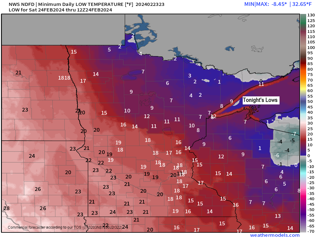
A cold night ahead as will see temperatures drop to the single digits below to around 10 above zero in the Northland.
It’ll be interesting to see how cold it’ll get around the Duluth area tonight with mainly clear skies and light winds along with a fresh snowpack which would typically be a good recipe for strong radiational cooling, but a warm air advection pattern will develop during the night as winds shift to the south, so I think temperatures will stay above zero in Duluth tonight.
Milder temperatures return this weekend with highs Saturday and Sunday in the 30s and 40s with Saturday looking like the warmest day of the weekend. It will be breezy, however, as southwest winds increase with gusts to around 15 to 30 mph on Saturday.
The official snowfall total for today’s lake effect snow event in Duluth was 0.7 inches (NWS location on top of the hill)
- 1.3 inches of snow so far this month in Duluth which is -10.9 inches below normal to date.
- Least snowy February on record for Duluth is 2.1 inches set in 1896. There’s still a chance that February 2024 will go into the record books as the least snowy February ever, but this will depend on what happens the middle of next week.
A few more snowfall reports from today
Source: National Weather Service Duluth, Minnesota
2 NNW Gary New Duluth, MN: 6.0″
Proctor, MN: 4.3″
1 NNW West Duluth, MN: 3.8″
Looking ahead to next week
A trough of low pressure is still forecast to move east out of the western U.S. early next week. This trough looks fairly progressive in the computer models which lowers the chance that will see a strong/slow moving system pass through the upper Midwest which would increase the chances for getting a more significant winter storm. Instead, it looks like will see a fast-moving trough/area of low pressure move across the area in the Tuesday-early Wednesday time frame with some precipitation in the form of snow or rain changing to snow.
This temperature contrast for early next week looks big, and sometimes these types of temperature contrasts can help spin up a larger system, so will see how the computer models trend the next few days.
Temperatures for next Tuesday are forecast to range from around 10 above zero in far northwest Minnesota with 60s in southern Wisconsin. The cold air will be on the move and will affect the Northland Tuesday night into Wednesday with another chance for subzero temperatures in parts of the Northland Wednesday morning.

Northern Minnesota (west/north of Duluth) has the greatest chance for seeing some snow accumulation during the day Tuesday with that chance shifting farther south/east into eastern Minnesota and northern Wisconsin Tuesday night-Wednesday morning.
At the moment this doesn’t look like it’ll be a major snow event in our area the middle of next week, but things could change.
Note: Snowfall totals in Duluth for next Tuesday-Wednesday ranges from 0″ to a high-end amount of 8″ via EPS 50-member snowfall forecast, but the majority of the members are at an inch or less.
Shown below is the NWS Blend of Models snowfall forecast for next week.

Thanks for reading!
Tim
Leave a Reply