6:45 PM Saturday, March 16, 2024
Signals continue to show up on the computer models which could support a more active weather pattern developing in the upper Midwest including for us here in the Northland beginning late next week and through the end of the month.
The first-time frame to monitor is around March 21-23, with other systems possible beyond that aforementioned time period.
The tracks of each system, where the cold air and warm air and rain/snow line set up is uncertain right now, and it will likely remain that way for a few more days. But the main takeaway is that the pattern has a chance to turn more active with at least a slight chance that a much stronger system could impact parts of the upper Midwest and the Northland later this month.
With El Nino fading away trending toward Enso Neutral conditions and eventually La Nina conditions by this summer, I think this may help shift the storm track slightly more to the north compared to what we’ve seen occur for the last few months where these larger systems have stayed well south of the Northland mainly impacting portions of the central Plains, Midwest and Ohio Valley which is typical during El Nino.
Also, we’re heading into one of our transition seasons, in this case going from winter to spring, and as spring approaches the jet stream tends to shift a bit more to the north as warmer air begins to shift farther north, so this too could help turn the pattern a bit more active in the upper Midwest over the next few weeks. Of course, with weather nothing is ever guaranteed.
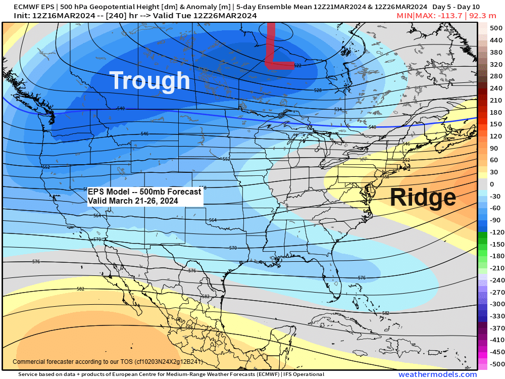
Cold air (blue and purple colors on the map below) is forecast to cover much of Canada into the western and northern U.S., late next week into the middle part of the following week, while warmer air (orange and red colors on the map below) is forecast to be in place over parts of the southern Plains and Midwest. Note: This clash in temperatures is one ingredient which may support an active storm track after March 22nd.

2023-2024 seasonal snowfall total for Duluth sits at 18.7 inches, and this is -56.3 inches below normal to date.
Keep in mind that Duluth averages 22.7 inches of snow during the spring or from March 1st to May 31st, I bring this up because there continue to be several EPS model members showing snowfall totals over the next 2 weeks pretty close to if not more snow than what we normally get the entire spring in Duluth.
Here’s the breakdown from the EPS 50-member snowfall forecast for Duluth over about the next 2 weeks or through March 31st.
- High-end amount is at 43 inches of snow
- 44/50 members forecast at least 4 inches of snow
- 26/50 members forecast at least 10 inches of snow
- 10/50 members forecast at least 20 inches of snow

Probabilities for greater than 12 inches of snow are currently highest in the black outlined area on the map below. Note: There’s no doubt will see this area shift north, south, east, and west over the next several days but how far from where the highest probs. are today? Only time will tell.
The forecast below is valid through 7 AM March 31st.

Here’s a look at what the ensemble models are showing for snowfall totals (10:1 snowfall ratio) through 7 AM Sunday, March 31st, 2024.
EPS model

GEFS model

CMCE model

In the short term we have lake effect snow to deal with along the South Shore of Lake Superior in northwest Wisconsin through Monday morning with snowfall totals of 3 to 6 inches or more east of Ashland, or from around Glidden and Butternut to Gile and Hurley.
A trace to 1 inch of snow is possible through Sunday in parts of northeast Minnesota and from Ashland on west in northwest Wisconsin.

NAM 3km model simulated radar forecast through 1 PM Monday.
Snow in blue colors on the loop below.

The 1st half of March was a warm one in the upper Midwest with average temperatures running some +10 to +15 degrees warmer than average.
Average Temperature and Departure from Normal in the Northland for March 2024 (through the 15th)
- Brainerd, MN: 37.3 degrees, +12.5 degrees above normal
- Ashland, WI: 36.6 degrees, +11.8 degrees above normal
- Duluth, MN: 36.0 degrees, +12.1 degrees above normal
- Hibbing, MN: 31.5 degrees, +11.4 degrees above normal
- International Falls, MN: 30.5 degrees, +11.0 degrees above normal
Lower 48 Temperature Anomaly for March 2024 (through the 15th)
Orange, red and white: Above normal temperatures
Blue and green: Below average temperatures

Average Temperatures and Departure from Normal for winter 2023-2024 (Dec. 1 – Feb. 29)
Ashland, WI: 27.6 degrees, +10.5 degrees above normal
Brainerd, MN: 25.1 degrees, +10.8 degrees above normal
Duluth, MN: 24.9 degrees, +10.3 degrees above normal
Hibbing, MN: 21.6 degrees, +11.9 degrees above normal
International Falls, MN: 21.3 degrees, +12.5 degrees above normal
Meteorological Winter (Dec. 1 – Feb. 29) 2023-2024 Average Temperature Ranks by state.
- Minnesota: Warmest on record
- Wisconsin: Warmest on record
- Michigan: Warmest on record
- North Dakota: 2nd warmest on record
- Iowa: 2nd warmest on record
- Ohio: 2nd warmest on record
- Illinois: 2nd warmest on record
- Missouri: 3rd warmest on record

A very active severe weather day on Thursday with 426 filtered severe weather reports stretching from Texas to Ohio.
22 tornado reports on Thursday with tornadoes reported in Illinois, Missouri, Indiana, Oklahoma, Ohio, Texas, Arkansas, Mississippi, and Alabama.

Thanks for reading!
Tim
Leave a Reply