6:17 PM Tuesday, April 16, 2024
The Northland will continue to experience a windy and rainy system through Wednesday.
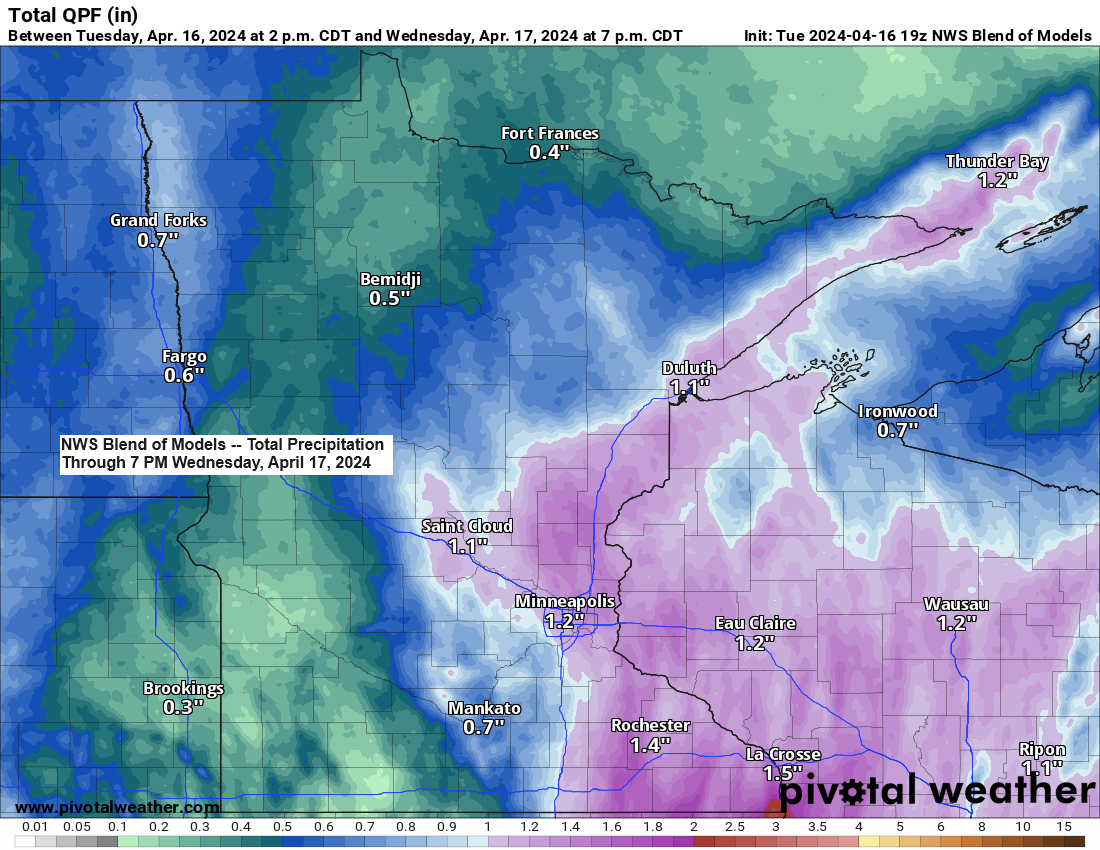
- Expected rainfall in the Northland varies, with totals from approximately 0.15 inches to over an inch. The higher amounts are anticipated in northwest Wisconsin, eastern Minnesota, and along the North Shore of Lake Superior.
- Rainfall is expected to decrease from west to east on Wednesday afternoon and early evening.
- Northeastern winds, gusting between 35 to 55 mph, are expected to persist in Duluth through tonight and into Wednesday morning, with the strongest gusts occurring this evening. These strong winds may lead to occasional power outages.
- For those interested in marine activities or wave watching — A Storm Warning is in effect from Two Harbors to Duluth, extending to Port Wing, with gusts exceeding 50 knots expected through this evening.
- Gale Warnings remain in effect across much of western Lake Superior until Wednesday morning.
- Significant waves ranging from 6 to 15 feet are anticipated along the western shores of Lake Superior from tonight through Wednesday morning.
Duluth area: Rain is expected tonight and into Wednesday, with intermittent breaks likely late tonight or early Wednesday morning. The rainfall is anticipated to lessen by mid to late Wednesday afternoon.
HRRR model simulated radar forecast through 7 PM Wednesday.

Today, the National Weather Service issued the year’s first tornado warning for Minnesota due to a severe thunderstorm that could have produced a tornado near Worthington, located in the state’s far southwest, at approximately 4 PM. Radar indicated the presence of the tornado.

A favorable setup is in place for a significant northeast wind event near Lake Superior, including the Twin Ports area. This is due to a robust high-pressure system, approximately 1033mb, centered over Hudson Bay, Canada, and a potent low-pressure system, around 991mb, ascending northeastward from far northeast Nebraska.
Today in Duluth, northeast winds have been gusting from 35 to 50 mph, with a peak gust reaching 52 mph at the Duluth Harbor as of 4 PM.

Strong northeast winds are expected to persist near Lake Superior tonight and into Wednesday morning, with gusts reaching up to 55 mph. The winds will weaken considerably for a period on Wednesday afternoon, only to pick up slightly later in the day, although they will shift to come from the northwest rather than the northeast.
HRRR model wind gust forecast through 7 PM Wednesday.

The Duluth area has experienced power outages this afternoon as a result of strong winds.

Severe thunderstorms, including the potential for tornadoes, are expected to persist through this evening across various regions of the Midwest, where multiple tornado and severe thunderstorm watches are currently active.

Today has seen significant severe weather activity in parts of the Midwest, with close to 100 instances of severe weather reported by 5 PM.
Tornadoes have been observed in eastern Nebraska, Iowa, northern Missouri, and far northern Kansas, with 16 preliminary reports of tornadoes today.

Take a look at the spring storm ascending northeastward into the upper Midwest tonight, as captured by GOES-16 satellite imagery.
Goes-16 infrared loop ending 4:56 PM CT Tuesday, April 16, 2024.

Goes-16 enhanced mid-level water vapor loop ending 5:01 PM CT, Tuesday, April 16, 2024.

A robust mid and upper-level trough, along with an upper low, will persist in moving northeast across the upper Midwest tonight and into Wednesday. This upper trough will generate increased lift over the Northland periodically through Wednesday, resulting in heavier downpours due to this intensified lifting effect.

Thanks for reading!
Tim
Leave a Reply