8:22 PM Saturday, May 18, 2024
Duluth, Minnesota experienced its first 80-degree day of the year today, Saturday, May 18, 2024, reaching a high of 81 degrees. This marks the first time Duluth has seen temperatures this warm since October 3rd, 2023.
Typically, Duluth experiences its first 80-degree day around May 23rd. In the previous year, this milestone was reached on May 11th. However, in 2022, the city did not see temperatures hit 80 degrees until June 19th.
Note: Today, between 5:15 and 5:35 PM, the temperature at the Duluth Harbor soared by nearly 20 degrees, from 57 to 75 degrees. This significant change was attributed to the wind direction, which predominantly blew from the east throughout the day, until a robust westerly wind emerged later in the afternoon. Typical spring weather in the Twin Ports!
- The weather will be primarily dry tonight and into Sunday.
- The likelihood of rain increases late Sunday night into Monday morning.
- A potent storm, bringing strong winds and heavy rainfall, is expected to arrive on Tuesday afternoon and persist into Wednesday.
- The active weather pattern is expected to continue until the end of the month, with numerous opportunities for rainfall.
The initial weather system is expected to arrive Sunday night and persist into Monday morning. However, the heaviest rainfall is anticipated to occur south/southeast of the Northland, with northern Minnesota, including the Twin Ports area, expecting less precipitation. Conversely, northwest Wisconsin may experience higher rainfall totals, being on the northern fringe of the heaviest rain projections.
Here’s the NWS Blend of Models rainfall forecast through 7 PM Monday.

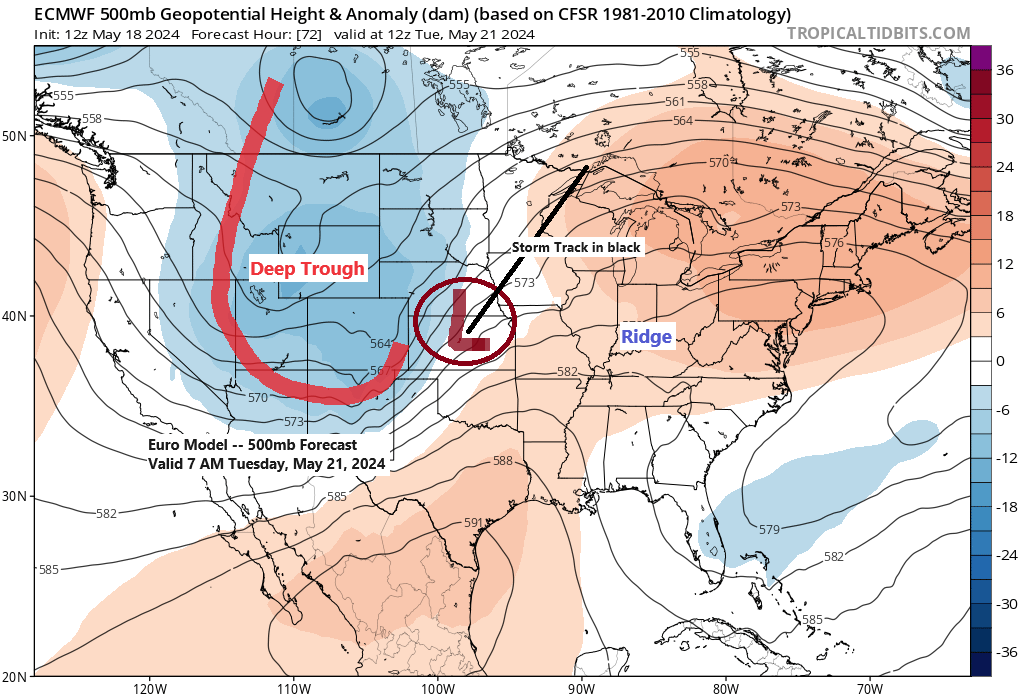
A more potent system is predicted to ascend northeastward from Kansas on Tuesday. This low-pressure area is expected to carry considerable moisture, with precipitable water values ranging from 1 to 1.5 inches, advancing northward from southern Minnesota. Additionally, the Northland should experience substantial uplift due to a particularly intense jet stream.
Rain from this storm is expected to move northward into our region by Tuesday afternoon and continue into early evening. The rainfall is anticipated to last through Tuesday night and may extend into much of Wednesday, contingent upon the speed at which the low-pressure system traverses the area.

There is a risk of flooding due to expected heavy rainfall from Tuesday afternoon to early Wednesday morning. The areas most likely to experience flooding are those within the yellow zone on the map, encompassing eastern Minnesota and a large portion of northwest Wisconsin.

This midweek storm may bring strong winds, with northeast gusts expected Tuesday into early Wednesday, transitioning to northwest by Wednesday afternoon.
Wind gusts ranging from 20 to 40 mph, or even stronger, may occur across much of the Northland from Tuesday afternoon through Wednesday night.
Euro model wind gust forecast valid 1 PM Tuesday to 7 AM Thursday.

Widespread rainfall, potentially exceeding 2 inches, is forecasted for the entirety of northeast Minnesota and northwest Wisconsin by month’s end per ensemble model forecasts.


An active period for severe thunderstorms is set to commence on Sunday and is expected to persist through Tuesday, presenting all forms of severe hazards such as large hail, damaging winds, and potential tornadoes.
The regions at risk include areas of the southern and central Plains as well as the mid and upper Mississippi Valley, with the highest threat levels predicted for Sunday and Tuesday.


A robust low-pressure system with an average measurement of 995mb was positioned over the far western region of Ontario, Canada, earlier this evening. An associated cold front progressed eastward across the Northland throughout the day.
Scattered showers and thunderstorms passed through parts of the region this morning, associated with a cold front and preceded by warm air advection ahead of the front.
This afternoon, scattered strong to severe thunderstorms redeveloped from southwest to north central Wisconsin into west central Upper Michigan. A few of these storms became severe, producing large hail up to the size of golf balls. Additionally, in western Upper Michigan, there were reports of hail measuring 2 inches in diameter, which is larger than golf ball size, particularly in the Ironwood and Bessemer areas.

An examination of the strong to severe thunderstorms that developed this afternoon across central Wisconsin and upper Michigan, as seen through visible satellite imagery.
Goes-16 visible satellite loop ending 6:46 PM CT, Saturday, May 18, 2024.

Goes-16 sandwich satellite loop ending 6:46 PM, Saturday, May 18, 2024.

A significant weather system is moving northeast across Ontario and the Great Lakes region this afternoon as seen on water vapor imagery.
Goes-16 water vapor loop ending 6:30 PM CT, Saturday, May 18, 2024.

Local Storm Reports from May 17-18, 2024
Source: National Weather Service Duluth, Minnesota
- 4:47 PM 5/18: Hail 1.50″. 8 NNW Mercer, WI (Iron County) Ping pong ball size hail.
- 4:41 PM 5/18: Hail 0.70″. Hurley, WI (Iron County)
- 6:18 PM 5/17: Hail 1.00″. Hill City, MN (Aitkin County) Quarter size hail.
- 6:18 PM 5/17: Hail 0.75″. Hill City, MN (Aitkin County)
- 5:35 PM 5/17: Hail 0.88″. 3 S Iron Junction, MN (St. Louis County)
- 5:31 PM 5/17: Hail 0.70″. 1 SE Remer, MN (Cass County)
- 5:30 PM 5/17: Hail 1.00″. 3 SSW Remer, MN (Cass County) Quarter size hail.
Thanks for reading!
Tim
Leave a Reply