7:00 PM Friday, May 17, 2024
- Expect isolated to scattered showers and thunderstorms from tonight until mid-afternoon on Saturday.
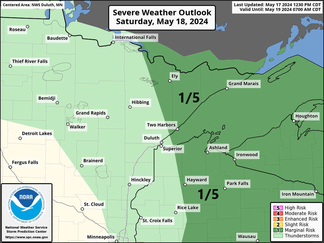
- There is a marginal risk (level 1 out of 5) for severe thunderstorms on Saturday afternoon across the Arrowhead region of Minnesota and into northern Wisconsin. The primary threats from these storms are damaging wind gusts up to 60 mph and large hail that could reach the size of a quarter.
- On Saturday afternoon, as winds begin to shift from the southwest, temperatures in Duluth, near Lake Superior, are expected to rise into the 70s during the mid to late afternoon hours.
- There are multiple opportunities for rain next week.
Note: In the near future, the chance of rain in Duluth is highest late tonight into Saturday morning, primarily before noon on Saturday.
NAM 3km model simulated radar forecast through 7 PM Saturday.

It appears that scattered thunderstorms will redevelop from mid to late afternoon on Saturday, with the highest likelihood occurring east of the Twin Ports.
HRW NSSL model forecast valid 4 PM Saturday, May 18, 2024.

Due to the sporadic nature of tonight’s and Saturday’s rainfall, totals will differ significantly across areas, with some receiving merely a trace and others potentially accumulating a quarter to a half-inch of rain.

This afternoon, a cold front over the northern Plains will move eastward, passing through the Northland from Saturday morning to mid-afternoon.
Ahead of this cold front, southerly winds will sustain a somewhat humid and unstable air mass over the Northland from tonight until mid-afternoon Saturday. The lift from the approaching frontal boundary is expected to generate isolated to scattered showers and thunderstorms in the area tonight through Saturday morning, with potential redevelopment Saturday afternoon from the Arrowhead of Minnesota to eastern parts of northwest Wisconsin.

This afternoon, there are two distinct areas of showers and thunderstorms. The first is associated with a cold front over the Dakotas, while a second batch of showers and thunderstorms is emerging over parts of Minnesota, near a warm frontal boundary.
Radar loop ending 5:36 PM Friday, May 17, 2024.
A severe thunderstorm watch remains in effect until early evening for central and western North Dakota, northwest South Dakota, and far eastern Montana. The primary threats are damaging wind gusts up to 75 mph and large hail measuring up to the size of a quarter or 1 inch in diameter.

This afternoon, the map indicates the highest instability in the blue areas and particularly in the yellow regions.

The region is experiencing a bit of humidity today with dew points varying from the upper forties to the fifties.

Goes-16 water vapor loop ending 6:40 PM CT, Friday, May 17, 2024.

The upcoming two-week forecast indicates an active weather pattern for the upper Midwest, with multiple rainy systems potentially affecting the Northland area.
Ensemble models remain in strong agreement about the rainfall totals, which are expected to reach 2 inches or more in the Northland by June 1st.
Next week, the forecast indicates chances of rain late Sunday night into Monday morning, again from Tuesday afternoon through Wednesday morning, and possibly around next Friday to Saturday.


Rainfall Reports from today, Friday, May 17, 2024, as of 6:49 PM
Source: MesoWest
Hibbing, MN: 0.42″
Cass Lake, MN: 0.27″
Eveleth-Virginia, MN: 0.26″
Walker, MN: 0.16″
Hill City, MN: 0.13″
Grand Rapids, MN: 0.12″
Moose Lake, MN: 0.11″
Brainerd, MN: 0.11″
Bigfork, MN: 0.10″
Saginaw, MN: 0.08″
Littlefork, MN: 0.07″
McGregor, MN: 0.07″
Isabella, MN: 0.06″
Ashland, WI: 0.06″
French River, MN: 0.05″
Duluth Airport: 0.05″
Northome, MN: 0.04″
Bay of Grand Marais, MN: 0.04″
International Falls, MN: 0.02″
Poplar, WI: 0.02″
Ely, MN: 0.02″
Duluth Sky Harbor Airport: 0.02″
Superior Airport: 0.02″
Siren, WI: 0.02″
Hayward, WI: 0.01″
The late spring day brought unusually warm temperatures to the region, with the mercury rising into the 80s across western, central, and southern Minnesota, extending into western Wisconsin. In southwest Minnesota, temperatures even soared into the 90s.
4 PM Temperatures 5/17/2024
Madison, MN: 93
Granite Falls, MN: 91
Marshall, MN: 90
Canby, MN: 90
Morris, MN: 90
Wheaton, MN: 90
Today, temperatures soared above 80 degrees, reaching as far north as Brainerd, Aitkin, Moose Lake, and Solon Springs.
This afternoon, cooler temperatures ranging from the upper 40s to 50s were recorded near Lake Superior, while areas farther inland in northern Minnesota experienced warmer conditions with temperatures in the 60s and 70s.

Thanks for reading!
Tim
Leave a Reply