6:16 PM Thursday, May 16, 2024
Another bout of rainfall may occur on Friday with a warm front moving northward across the Northland.
On Saturday, a cold front will move east across the region, potentially bringing isolated to scattered showers or thunderstorms, primarily in the morning and early afternoon. There’s also a chance for redevelopment, mainly in the eastern parts of northwest Wisconsin, during the afternoon.
There are at least two more opportunities for rainfall next week. The first is expected Sunday night into Monday morning, followed by another possibility on Tuesday.
Looking ahead, there may be a system that could bring wet conditions to the Northland area late next week or during the next weekend (~May 24-26).
Rainfall totals for May 2024 have been updated through 4 PM on the 16th.
International Falls, MN
Total: 1.88″
Departure: +0.51″ above normal
Percent of normal: 137% of normal
Duluth, MN
Total: 1.85″
Departure: +0.22″ above normal
Percent of normal: 113% of normal
Hibbing, MN
Total: 1.50″
Departure: +0.24″ above normal
Percent of normal: 119% of normal
Brainerd, MN
Total: 1.42″
Departure: -0.11″ below normal
Percent of normal: 93% of normal
Ashland, WI
Total: 1.00″
Departure: -0.67″ below normal
Percent of normal: 60% of normal
Here’s the 500mb forecast for Friday per NAM model.
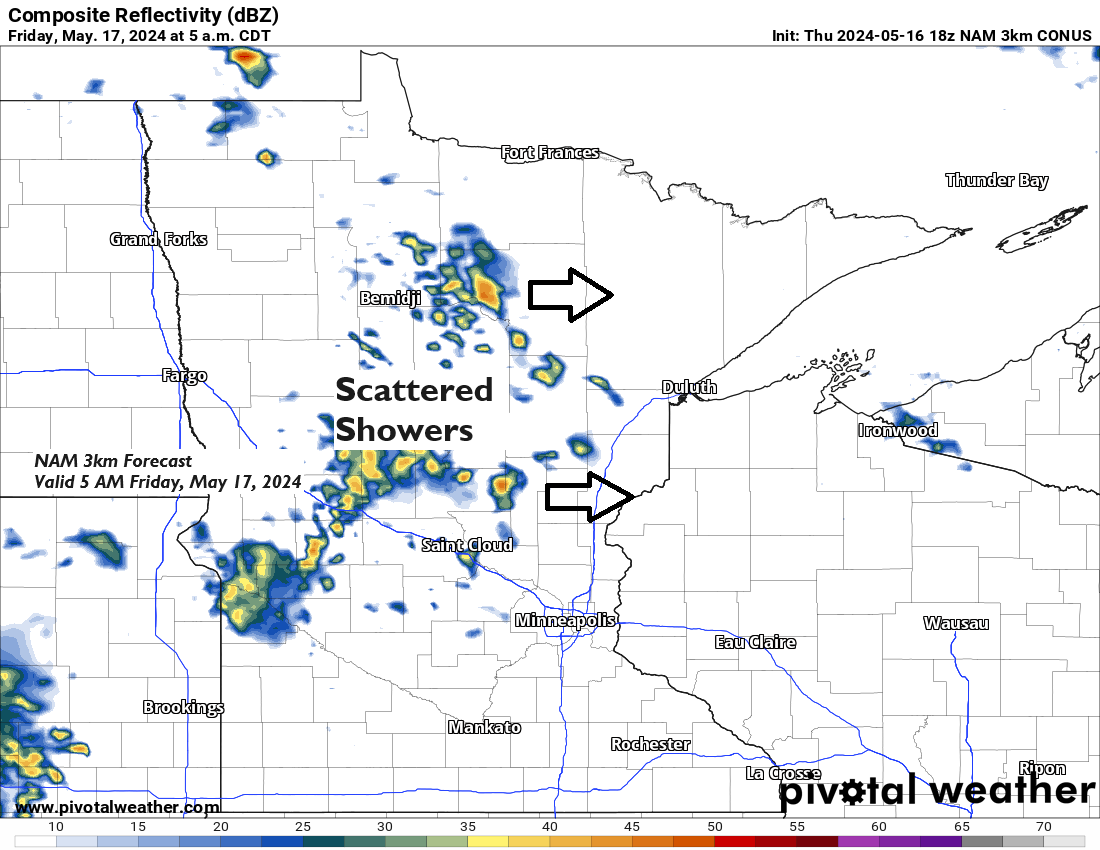
The region marked in black on the map indicates a disturbance that will shift eastward from the eastern Dakotas and western Minnesota on Friday morning. This disturbance, linked with atmospheric lift and a nearby warm front, is expected to generate additional showers in the Northland on Friday.

NAM 3km model simulated radar forecast valid from 1 AM tonight to 7 PM Friday.

When examining potential rainfall totals for Friday, there are discrepancies among the computer models. Some predict generally dry conditions or at most isolated showers, while others forecast more widespread showers and higher rainfall totals in parts of the Northland.
Here’s the NAM 3km model rainfall forecast through 7 PM Friday.

HRRR model total rainfall through 7 PM Friday.

- Last night’s weather system brought significant rainfall to parts of northern Minnesota, with amounts varying from half an inch to more than an inch.
- In parts of eastern Minnesota, the rainfall totals were typically less than 0.10 inches, marking the area with the least amount of rain.
- In the Duluth area, rainfall totals varied between approximately 0.15 inches and nearly 0.40 inches.

24-Hour Rainfall Reports from May 15-16, 2024, as of 6:05 PM on the 16th
Source: MesoWest
Bigfork, MN: 1.20″
Orr, MN: 1.12″
Littlefork, MN: 1.04″
Northome, MN: 1.01″
International Falls, MN: 0.87″
Nashwauk, MN: 0.78″
Keewatin, MN: 0.68″
Cass Lake, MN: 0.67″
Hibbing, MN: 0.63″
Grand Rapids, MN: 0.54″
Cook, MN: 0.49″
Glidden, WI: 0.45″
Walker, MN: 0.42″
Hill City, MN: 0.41″
French River, MN: 0.39″
Clam Lake, WI: 0.38″
Duluth, MN: 0.37″
Ashland, WI: 0.36″
Eveleth-Virginia, MN: 0.35″
Brainerd, MN: 0.32″
Washburn, WI: 0.32″
Winton, MN: 0.31″
Hayward, WI: 0.29″
Two Harbors, MN: 0.27″
Odanah, WI: 0.25″
Poplar, WI: 0.24″
Cable, WI: 0.23″
Ely, MN: 0.21″
Webb Lake, WI: 0.20″
Duluth Sky Harbor Airport: 0.19″
Siren, WI: 0.18″
Minong, WI: 0.17″
Spooner, WI: 0.17″
Danbury, WI: 0.16″
Solon Springs, WI: 0.16″
Duluth Airport: 0.15″
Hermantown, MN: 0.14″
Isabella, MN: 0.11″
Saginaw, MN: 0.09″
Bay of Grand Marais, MN: 0.09″
McGregor, MN: 0.06″
Moose Lake, MN: 0.06″
The initial weather system that delivered rain to the Northland area last night and this morning is moving eastward this afternoon. We’re even being treated to a bit of late afternoon sunshine in Duluth, which is always a pleasant sight.
Goes-16 visible satellite loop ending 5:40 PM CT, Thursday, May 16, 2024.

Goes-16 water vapor loop ending 5:40 PM CT, Thursday, May 16, 2024.

The remainder of this month appears to be intermittently active throughout the upper Midwest, with multiple systems queued up that could deliver more rain to the Northland.
The consensus among ensemble models continues to indicate widespread rainfall of 2 inches or more across the Northland until May 31st.


On average, Duluth experiences six days in May with high temperatures reaching at least 70 degrees. This May, there has only been one day at or above 70 degrees, but the forecast suggests we’ll see additional 70-degree days over the weekend.
The next few days, starting Friday, are expected to bring much warmer temperatures, with highs in the 60s and 70s in northeast Minnesota and northwest Wisconsin, and even reaching into the 80s in western, central, and southern Minnesota, as well as far western Wisconsin.
The east wind is expected to persist near Lake Superior on Friday, maintaining temperatures in the 40s and 50s within approximately 15 miles of the lake.
Note: Should clouds and showers become more prevalent in our area on Friday, it is likely that temperatures will be cooler than those indicated on the map.

It appears that Duluth will experience a wind shift from the east to the west on Saturday, which may take some time to happen. Consequently, we might see temperatures in the 40s during the morning, but as the west wind sets in by mid or late afternoon, they could rapidly rise into the 70s.

On Sunday, the forecast suggests that temperatures in Duluth may begin mild with westerly winds. However, should the winds shift eastward later in the day, it is expected that temperatures will decrease by late afternoon or evening.

Thanks for reading!
Tim
Leave a Reply