5:52 PM Thursday, June 6, 2024
Scattered showers will persist, moving southeast across the Northland this evening, then giving way to dry conditions overnight and into Friday. However, a new system from North Dakota may introduce additional rainfall to parts of the Northland from late Friday night into early Saturday morning.
-Today, June 6th, signifies the seventh consecutive day that Duluth has received at least 0.01 inches of rain.
-To find the last instance when Duluth experienced more than two consecutive days without rain, one must look back to mid-May (May 11th-14th).
-The Northland region has experienced rainfall ranging from 1 to over 2 inches above the average within the first six days of this month, one exception being International Falls which is running about a quarter inch below normal in rainfall so far this month.
Rainfall totals for June 2024 through 4 PM on the 6th
Ashland, WI
Total: 3.50″
Normal: 0.77″
Departure: +2.73″ above normal
Percent of normal rainfall: 454% of normal
Brainerd, MN
Total: 3.14″
Normal: 0.75″
Departure: +2.39″ above normal
Percent of normal rainfall: 419% of normal
Duluth, MN
Total: 2.53″
Normal: 0.74″
Departure: +1.79″ above normal
Percent of normal rainfall: 351% of normal
Hibbing, MN
Total: 1.32″
Normal: 0.72″
Departure: +0.61″ above normal
Percent of normal rainfall: 183% of normal
International Falls, MN
Total: 0.47″
Normal: 0.71″
Departure: -0.24″ below normal
Percent of normal rainfall: 66% of normal
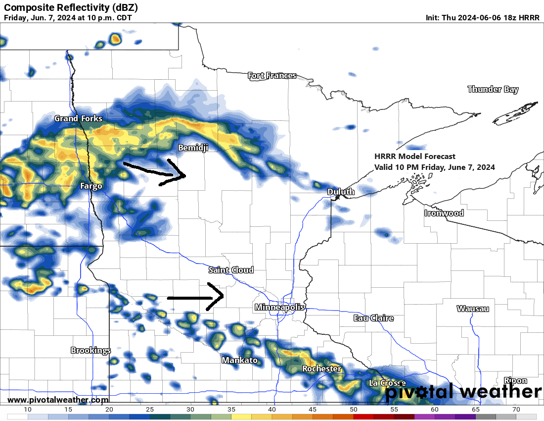
Two weather disturbances, carried by the west-northwest flow, are expected to move southeastward from the northern Plains on Friday.

Note: Should rain arrive in Duluth, it is not expected until late Friday night or early Saturday morning, starting after 11 PM on Friday.
HRRR model simulated radar forecast valid from 7 PM Friday to 1 PM Saturday.

Additional damage reports have emerged due to the damaging wind gusts from Wednesday’s thunderstorms that affected parts of northeast Minnesota and northwest Wisconsin.

Additional storm reports from Wednesday, June 5, 2024
Source: National Weather Service Duluth, Minnesota
- 5:21 PM: Thunderstorm Wind Damage. 2 W Delta, WI (Bayfield County) Many trees down throughout a campground. These all appear to be large and healthy trees that were uprooted due to strong thunderstorm winds.
- 5:15 PM: Thunderstorm Wind Damage. Iron River, WI (Bayfield County) A partially dead or at least sick tree snapped at the trunk about 10 feet from the base right in the town of Iron River.
- 5:10 PM: Thunderstorm Wind Damage. 1 N Cloquet, MN (Carlton County) Tree fallen down over a fence in the north side of Cloquet area. The tree was large enough to cause damage to the fence upon falling. The tree appeared healthy.
- 5:03 PM: Thunderstorm Wind Damage. 4 WNW Wabedo, MN (Cass County) A few trees 14 inches in diameter snapped at the trunk in a concentrated area.
- 4:54 PM: Thunderstorm Wind Damage. 3 SW Grand Rapids, MN (Itasca County) Several trees downed on the Pokegama Golf Course.
- 4:45 PM: Thunderstorm Wind Damage. 4 S Superior, WI (Douglas County) Uprooted tree about 2 foot diameter laying on the ground in the Village of Superior near WI Hwy 105 and Hwy 35.
- 3:25 PM: Thunderstorm Wind Damage. 9 WSW Mellen, WI (Ashland County) 4 trees laying on Highway GG between Clam Lake and Mellen in central Ashland County.
- 2:57 PM: Thunderstorm Wind Damage. Virginia, MN (St. Louis County) A large pine tree fallen across 5th Avenue in Virginia.
- 2:55 PM: Thunderstorm Wind Damage. 2 S Delta, WI (Bayfield County) Reports of trees down on roadways especially County Highway H along Scenic Drive and Yderstad Road and related driveways between the Village Delta and the town of Drummond in central Bayfield County.
The Northland experienced a chilly early June day, blanketed by an overcast sky. Afternoon temperatures hovered in the mid-50s to low 60s, accompanied by brisk westerly or northwesterly winds.
Visible satellite loop ends 4:30 PM Thursday, June 6, 2024.
This afternoon, temperatures in the Northland were approximately 5 to 15 degrees below normal.

Today, a heat dome enveloped the central and southern Rockies, while another upper-level ridge was centered over northeast Canada. Between these two ridges, a robust upper-level trough extended from central Canada to the upper Midwest and the Great Lakes region.
Beneath the heat dome, temperatures at the 850mb level soared to +35C, whereas under the trough, they plummeted to -3C. In northern Saskatchewan, Canada, this contrast even resulted in a bit of snowfall today.

Goes-16 water vapor loop from Thursday, June 6, 2024. Loop time ends 5:40 PM CT.

This afternoon, widespread temperatures in the 90s and 100s were found across the southern and southwestern US.

Thanks for reading!
Tim
Leave a Reply