6:26 PM Monday, June 17, 2024
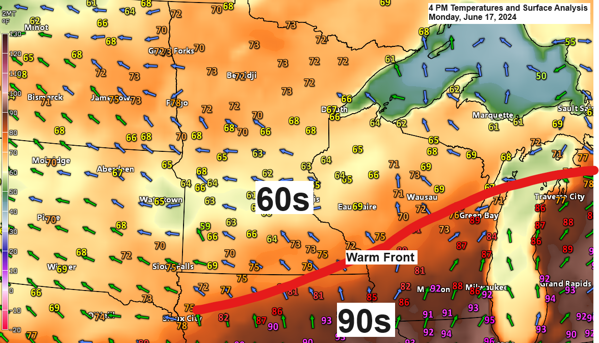
There has been minimal northward movement of the warm front today; it remained near the Iowa-Minnesota border late this afternoon. The warm front is expected to start moving northward tonight and is forecasted to reach northern Minnesota by daybreak on Tuesday, before continuing north into Ontario by Tuesday afternoon.
This afternoon, temperatures north of the warm front were in the 60s and lower 70s, whereas areas south of the warm front experienced the onset of heat with temperatures reaching the lower 90s.
This afternoon, significantly higher dew points, indicating muggier conditions, were observed south of the warm front, with dew points ranging from the mid-60s to the low 70s. Meanwhile, a drier air mass with dew points in the 40s and 50s prevailed over northeast Minnesota and northwest Wisconsin.

Humidity is expected to increase significantly across the Northland on Tuesday, with a warm front moving northward and moisture accumulating ahead of an eastward-moving cold front from western Minnesota. Dew points are anticipated to reach the upper 60s to low to mid 70s in much of the Northland by Tuesday afternoon. However, this humid air mass will be short-lived as drier air is forecasted to return by Wednesday.

The blue hues on today’s radar over western Montana indicate snowfall.
In other regions, bands of showers and thunderstorms are moving east-northeast across sections of the northern Plains and the upper Midwest.
Radar loop ends 5:28 PM Monday, June 17, 2024.
- Scattered showers and thunderstorms are expected to develop and move across northern Minnesota later tonight into Tuesday morning.
- Another wave of showers and thunderstorms is expected to move from west to east across the Northland from mid to late afternoon Tuesday into Tuesday evening, in association with a cold front moving eastward.
- Rain is expected to move out of the Northland area to the north/east by late Tuesday night.
NAM 3km model simulated radar forecast through 1 AM Wednesday.

The forecast indicates a likelihood of half an inch to an inch of rain across much of northeast Minnesota and northwest Wisconsin through Tuesday night. Localized areas could receive more than 2 inches.
Note: The risk of widespread flooding in our area has significantly diminished, yet the possibility of localized flooding remains for late tonight into Tuesday morning, and again later in the afternoon or evening of Tuesday.

In the span of 34 days since May 15th, Duluth has experienced only 7 days without rain.
The longest period without rain in Duluth since May 15th lasted two days, occurring from May 29th to 30th and once more between June 9th and 10th.

The Northland is at risk of experiencing a few strong to severe thunderstorms from Tuesday into Tuesday evening, particularly in the areas highlighted in yellow on the map. The main threats on Tuesday are damaging wind gusts up to 60 mph and large hail ranging from a quarter to the size of a ping pong ball (1″-1.5″ in diameter).

This is about as active as it can get in mid-June.
-Winter storm warnings and advisories are in effect for a late-season snowfall across the higher elevations of western Montana and central Idaho.
-There is a threat of flooding in parts of the Northern Plains and Upper Midwest, as well as in Southern and Eastern Texas.
-Concerns about fire weather are present in parts of the southwestern U.S. and California.
-There is potential for frost and freezing conditions in areas of Oregon, California, and Nevada.
-There is potential for a tropical storm to develop in the western Gulf of Mexico, with the system possibly making landfall in northern Mexico late Wednesday night.
-And finally, the heatwave that is enveloping parts of the Midwest, Ohio Valley, and Northeast U.S.

Today, a robust trough enveloped the western United States, while an upper-level ridge, also known as a heat dome, further intensified over the eastern United States.

Late-season snowfall is occurring in the higher elevations of western Montana and central Idaho, with winter storm warnings and advisories remaining in effect until Tuesday.

The remainder of this month appears to remain quite active, with forecasts suggesting the possibility of widespread rainfall exceeding 3 inches in northeast Minnesota and northwest Wisconsin according to ensemble model predictions.
Note: Our next chance for rain after Tuesday comes later this week, in the Thursday night-Saturday time frame.


Round after round of showers and thunderstorms have been tracking east-northeast across portions of the upper Midwest today.
Goes-16 sandwich satellite loop from Monday, June 17, 2024, loop time ends 4:21 PM

Goes-16 water vapor loop from Monday, June 17, 2024, loop time ends 4:20 PM.

Thanks for reading!
Tim
Leave a Reply