5:52 PM Sunday, August 4, 2024
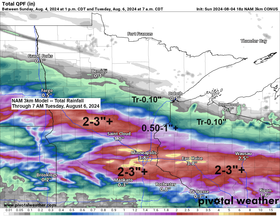
A low-pressure system moving east-southeast from far northwest Nebraska is expected to persist until early Tuesday morning. This system is forecasted to cause widespread rainfall across western, central, and southern Minnesota, extending into much of Wisconsin from Monday into early Tuesday. Additionally, there is a possibility of severe thunderstorms on Monday afternoon and evening in southern Minnesota and southern Wisconsin.
The Northland is expected to be on the northern side of this system, which means that most of our area will likely see significantly less rain on Monday. This is due to the high pressure from the north pushing drier air southward from Central Canada.
Rain is still expected, particularly along and south of Highway 2 in northeast Minnesota, and also across a large portion of northwest Wisconsin. The rainfall in our region is forecasted to begin late Monday morning or in the afternoon, continuing into the evening, and then tapering off later in the night.
Note: Should Duluth receive rain on Monday, it is expected to begin later in the afternoon, possibly around the 3 or 4 PM time frame, and it is anticipated to cease before late evening.
HRRR model simulated radar forecast valid 7 AM Monday to 11 PM Monday.

Severe weather outlook for Monday, August 5, 2024.

Sunday afternoon surface analysis.
High pressure – Blue
Low pressure – Red

On Monday, far northern Minnesota will experience drier air, while a significantly higher level of moisture will envelop the remainder of Minnesota and a large portion of Wisconsin.

Make a one-time donation
Make a monthly donation
Make a yearly donation
Choose an amount
Or enter a custom amount
Your contribution is appreciated.
Your contribution is appreciated.
Your contribution is appreciated.
The weather system for Monday will exhibit autumn-like characteristics, with a significant variation in 850mb temperatures across the region. These are expected to range from about +8C in central Minnesota to as high as +25C in the far south of the state.

On Monday, temperatures in Minnesota will see significant variation, with highs around 80 degrees in the far southwest, 60s in central regions, and approximately 70 degrees in the north.

Duluth won’t see temperatures in the 80s this week, but computer models suggest a warmer trend may reemerge around the middle of the month.

Thanks for reading!
Tim
Leave a Reply