6:14 PM Tuesday, February 4, 2025
-More snow is on the way, with a good chance for at least two inches of accumulation across the Northland.
-Most of Wednesday will be dry in the Northland, but snow chances will increase from southwest to northeast later in the afternoon and evening.
-Heaviest snow is expected from Wednesday evening to early Thursday morning, with snowfall rates possibly reaching half an inch or more at times.
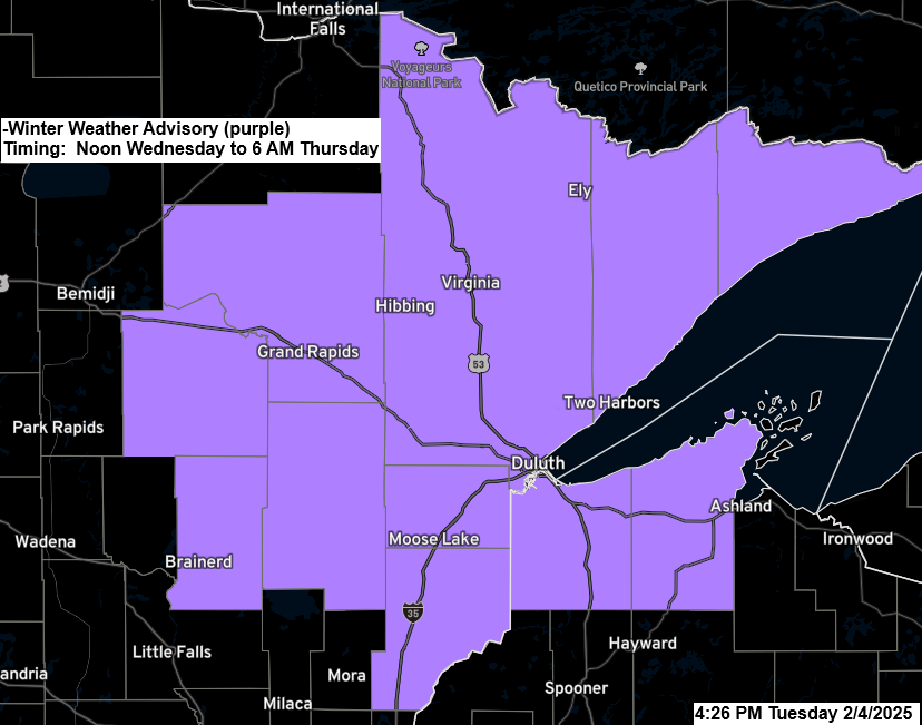
-Winter Weather Advisory is in effect Wednesday afternoon to early Thursday morning for all of northeast Minnesota and far northwest Wisconsin.

Here’s my updated snowfall forecast for Wednesday afternoon to Thursday morning.
- Generally looking at 3 to 5 inches of snow to the north and 1 to 3 inches of snow to the south.
- Duluth metro area: 3 to 5 inches of snow is possible by early Thursday morning.
Notes
*There’s an 80% chance of over 2 inches of snow in Duluth according to the Euro ensemble model, with a maximum of 4 inches possible (10% chance).
*Localized convective snow bands may develop in parts of the area Wednesday night and if they do occur and setup over an area long enough snow totals may exceed 5 inches.
*One concern would be the progressive nature to this system which may cut down on snow amounts in parts of the area.
*Temperatures are expected to be between 15 and 20 degrees, so the snow should be fluffy.
*Southeast winds at 10 to 20 mph Wednesday afternoon/evening may lead to some blowing snow.
*Stronger west winds with gusts to 30 mph will come Thursday, bringing more cold air and subzero temperatures for Thursday night and Friday morning.

Note: Snow chances for Duluth increase especially after 6 PM Wednesday.
NAM 3km model simulated radar forecast valid Noon Wednesday to 6 AM Thursday.

The orange, red, and purple colors on the loop indicate increased lift moving northeast across the Northland late Wednesday afternoon into Wednesday night, which may result in bursts of heavier snowfall with rates of around half an inch or more per hour.
RAP model 500mb vertical velocity forecast valid 12 PM Wednesday to 6 AM Thursday.

All 20 GEFS model members predict snow in the Northland at midnight on Wednesday, indicating a strong likelihood of snowfall. The uncertain factors are the duration of the snow and the total accumulation.

The next wave (shown in black on the map) will come from the Pacific Northwest on Wednesday morning. It will quickly move east-northeast across the northern Plains and upper Midwest from Wednesday night to Thursday morning.

Here’s a look at the Euro ensemble model 500mb forecast from 6 AM Wednesday to 6 PM Thursday. The blue and green colors over the upper Midwest indicate lower 500mb heights as the system from the Pacific Northwest moves in.

Low Temperatures in the Northland from Tuesday morning 2/4/2025
Hibbing, MN: -21
International Falls, MN: -17
Duluth, MN: -10
Brainerd, MN: -8
Ashland, WI: 0
Another day with a major contrast in temperature ranging from single digits above zero to single digits below zero across the northern Rockies and northern Plains, extending into central Canada, to the 70s and 80s over the southern U.S.

And separating the Arctic air from the warmer air is a very strong jet stream with winds of >140 knots located northeast of the Great Lakes this afternoon.

Central and northern California are experiencing heavy rain today, leading to flooding near San Francisco and some severe thunderstorms, while mountain areas are getting snow.
Radar loop ends 4:40 PM CT Tuesday, February 4, 2025.
Make a one-time donation
Make a monthly donation
Make a yearly donation
Choose an amount
Or enter a custom amount
Your contribution is appreciated.
Your contribution is appreciated.
Your contribution is appreciated.
Saturday snow chances
Another wave is forecast to move out of the western High Plains/northern Plains region on Saturday. This system will likely bring another round of accumulating snow to parts of the Upper Midwest on Saturday.

There are still differences in the computer models regarding snow totals and how far north the snow spreads on Saturday, but currently, it appears that central Minnesota into central Wisconsin has the greatest potential for significant snow amounts of 4 or more inches on Saturday, with lesser amounts of snow possible farther north, including for Duluth.
With this system still a few days away, this forecast could change.
Below is the Euro ensemble model probability for 4 or more inches of snow for Saturday.

Thanks for reading!
Leave a Reply