6:05 PM Thursday, February 13, 2025
Temperatures will warm up slightly over the next few days, replacing the arctic air with some snow, before more arctic air returns later this weekend and into much of next week.
– Accumulating snow is expected in parts of the Northland from Friday afternoon to early Saturday morning.
-Gusty winds may cause intermittent blowing snow from Friday evening through the weekend.
-There is a possibility of lake effect or lake enhanced snow near Lake Superior and in the Duluth metro area on Friday evening and overnight.
-Annual subscription to my blog has been reduced to $25, or a monthly subscription is $7. Subscribers gain early access to my snowfall forecasts and analysis of systems impacting the Northland, as well as long-range forecast discussions. The link to subscribe can be found below.
Subzero temperatures are likely across the Northland once again tonight, but temperatures shouldn’t be as frigid as they have been the last few nights. Tonight’s lows are forecast to range from around 5 below zero to 20 below zero across the Northland.
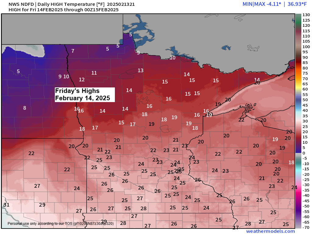
Highs on Friday are forecast to range from the teens to lower 20s.

Snow Friday
As stronger lift (shown in darker orange/red colors on the map) arrives from central Minnesota Friday afternoon, we should see an area of snow break out, and this snow will spread east/northeast into parts of the Northland later Friday afternoon and continue into Friday evening before tapering off early Saturday morning.
Here’s the NAM model 700mb forecast valid 6 AM Friday to 6 AM Saturday.

Duluth area: Chances for snow will increase after 12 PM Friday, with some snow expected late Friday afternoon through Friday night, ending early to mid-morning on Saturday. Winds will become east on Friday, with gusts up to 20 mph. Winds will shift to the north on Saturday. Patchy blowing snow is possible from Friday evening into Saturday.
NAM 3km model simulated radar forecast valid 12 PM Friday to 12 PM Saturday.

Active weather patterns continue today with one trough impacting eastern Canada, the eastern Great Lakes, and the northeast U.S., and another trough across the western U.S.

Plenty of Arctic air continues today across Canada into the northern U.S., with much warmer conditions in the far south, particularly in central and South Florida.


Subscribe to continue reading
Become a paid subscriber to get access to the rest of this post and other exclusive content.