5:26 PM Tuesday, May 20, 2025
-Strong northeast winds will persist tonight and Wednesday near Lake Superior, including Duluth, with gusts of 25 to 45 mph, reaching up to 55 mph this evening.
-Winds in Duluth have been blowing at 50 to 60 mph today, causing power outages in some areas. The Duluth Harbor has recorded a steady wind of at least 40 mph for 7 hours since 9:15 AM, and through 4:15 PM.
-A Gale Warning remains in effect through Wednesday afternoon for western Lake Superior, while a Storm Warning is in place until early this evening at the head of the lake.
-Much less wind and milder temperatures for Thursday with highs in the mid 50s to mid 60s.
-Dry weather returns after tonight’s rain with highs mainly in the 60s for Memorial Day weekend.
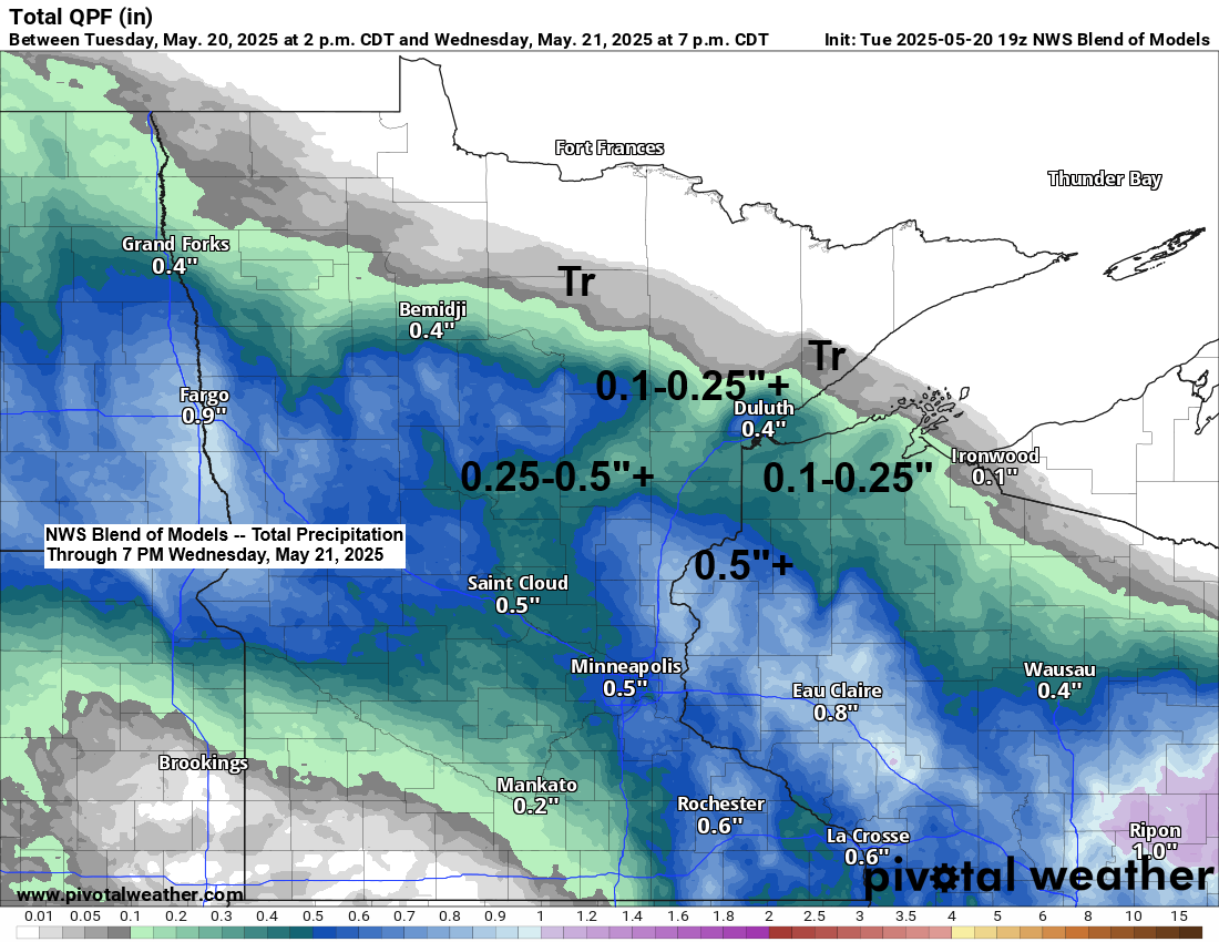
-Regarding rainfall amounts tonight, Duluth is not expected to receive significant rain, with totals generally around a quarter inch or less. Higher amounts are anticipated farther to the south.
Over an inch of rain fell in Brainerd today, about half an inch in Danbury, and over a quarter of an inch in McGregor.
24-Hour Rainfall Reports as of 5:01 PM Tuesday, May 20, 2025
Brainerd, MN: 1.13″
Siren, WI: 0.77″
Danbury, WI: 0.53″
Hinckley, MN: 0.47″
McGregor, MN: 0.35″
Walker, MN: 0.34″
Webb Lake, WI: 0.33″
Hill City, MN: 0.22″
Spooner, WI: 0.17″
Hayward, WI: 0.16″
Winter, WI: 0.14″
Moose Lake, MN: 0.13″
Minong, WI: 0.13″
Glidden, WI: 0.05″
Clam Lake, WI: 0.04″
Cable, WI: 0.03″
Grand Rapids, MN: 0.01″
Saginaw, MN: 0.01″
Solon Springs, WI: 0.01″
Poplar, WI: 0.01″
Peak wind gusts from May 20, 2025 as of 4 PM
Duluth Airport: 53 mph
Ashland, WI: 45 mph
Hibbing, MN: 44 mph
International Falls, MN: 40 mph
Brainerd, MN: 36 mph
Local Storm Reports from May 20, 2025
- 4:04 PM: Non-Thunderstorm Wind Damage. 2 E Hermantown, MN (St. Louis County) Tree down.
- 2:01 PM: Non-Thunderstorm Wind Damage. 13 NNE Wales, MN (Lake County) Tree snapped near the base and down blocking one lane of Forest Highway 15 near Scott Junction.
- 8:30 AM: Non-Thunderstorm Wind Damage. 3 WSW Lester Park, MN (St. Louis County) Large tree branch down blocking the road.
Rain has been falling today across the southern regions of the Northland, extending from east-central Minnesota into northwest Wisconsin. This area of precipitation has been steadily advancing northward, and as of 4 PM rain has commenced in Duluth and Floodwood while approaching Grand Rapids.
This rain is happening far north of a low-pressure system that was in eastern Iowa today. This system will keep moving east and go through the Ohio Valley on Wednesday.

Reports indicate sleet mixing with rain late this afternoon in the Duluth area. Dew points range from the upper 20s to mid-30s, with wet bulb temperatures as low as 31 at the Duluth Airport. These conditions support the occurrence of frozen precipitation types along with the rain this evening.
Radar loop ends 4:45 PM Tuesday, May 20, 2025.
Rain is expected to diminish from north to south across the Northland on Wednesday, with precipitation in Duluth concluding between 4 and 8 AM.
NAM 3km model simulated radar forecast through 7 PM Wednesday.

A pronounced moisture gradient is present across the Northland today, with precipitable water values ranging from approximately 0.2 inches in far northeast Minnesota to over 0.5 inches in Duluth, and up to around 0.8 inches in the Brainerd Lakes region.

The upper Midwest has a notable system today.
Goes-16 enhanced water vapor loop ending 4:41 PM CT Tuesday, May 20, 2025.

Thanks for reading!
Leave a Reply