5:28 PM Monday, May 19, 2025
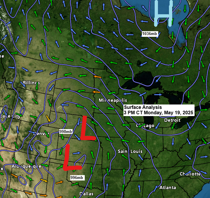
Strong high pressure around 1035mb over Hudson Bay, Canada, will continue pushing dry air south into the Northland, while a low-pressure system averaging 995mb moves east from the central Plains through Wednesday. A tight pressure gradient between the high to the north and low to the south will create strong northeasterly winds across the Northland, particularly near Lake Superior and in the Twin Ports, where wind gusts of 35 to 55 mph are likely at times through Wednesday.
A peak wind gust of44 mph was reported at the Duluth Airport today, while the Duluth Sky Harbor Airport recorded a peak wind gust of 48 mph so far. Additionally, winds at the Duluth Harbor have been sustained at a minimum of 35 mph since approximately 10 AM this morning.

Updated precipitation anomalies for the Northland as of 4 PM May 19, 2025
Duluth, MN
Month to date: -0.88″ below normal
Since March 1st: -0.86″ below normal
Since January 1st: -1.25″ below normal
International Falls, MN
Month to date: -1.18″ below normal
Since March 1st: -0.18″ below normal
Since January 1st: -0.45″ below normal
Ashland, WI
Month to date: -1.59″ below normal
Brainerd, MN
Month to date: -1.00″ below normal
Hibbing, MN
Month to date: -0.48″ below normal
There is a lot of dry air in the Northland, with moisture levels ranging from 0.2 inches in the Arrowhead to about 0.5 inches near the Brainerd Lakes.
Deeper moisture with PWATS of 1″ or more was observed in southern Minnesota and further south today.
With the high-pressure system situated to our north, it should continue to channel dry air southward into much of the Northland through midweek.

Rain will mainly fall in western, central, eastern, and southern Minnesota and parts of Wisconsin, while northeast Minnesota and far northern Wisconsin will remain dry through Tuesday afternoon.
By Tuesday night, there is a possibility for the northern edge of this rain to extend as far north as Grand Rapids, Duluth, and Ashland. However, I believe some of the computer models project this rain too far north for Tuesday night. I will reassess the situation on Tuesday afternoon.
Note: There is also a possibility of light snow or a rain/snow mixture developing briefly on Tuesday night into early Wednesday morning in portions of west-central Minnesota and extending westward into parts of the Dakotas.
HRRR model simulated radar forecast through 1 PM Wednesday.

Significant rainfall accumulations of 1 to 2 inches or more are expected through Wednesday across much of western, central, eastern, and southern Minnesota, as well as western, central, and southern Wisconsin, while northeast Minnesota and far northern Wisconsin are likely to experience little to no precipitation from this system.

Rain is falling today in the Dakotas and western Minnesota, with showers and storms impacting the central and southern Plains.
Tornado Watch (red outlined area)
Severe Thunderstorm Watch (yellow outlined area)
Tornado warning (red polygon)
Severe thunderstorm warning (yellow polygon)
Flash flood warning (green polygon)
Radar loop ends 3:58 PM CT Monday, May 19, 2025.
A strong late spring storm is hitting the Rockies and Plains today.
Goes-16 enhanced water vapor loop ending 3:51 PM CT Monday, May 19, 2025.

Thanks for reading!
Leave a Reply