It was a warm mid-September day in the Northland, with most areas seeing temperatures in the 80s. However, the southerly winds weren’t strong enough to clear the marine layer lingering near Lake Superior. While the easterly wind was much lighter compared to previous days, temperatures near the lake stayed cooler, ranging from the 60s to lower 70s.
Although it was a warm day in our area, no new high-temperature records were tied or broken for September 16th.
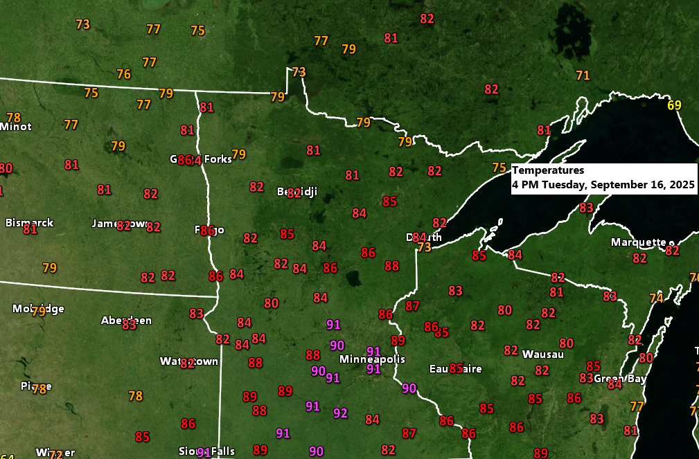
Today’s high temperatures in the Northland and their departure from the average for September 16th.
Brainerd: 88
Departure: +17 degrees above normal
Duluth: 85
Departure: +18 degrees above normal
Hibbing: 85
Departure: +19 degrees above normal
Ashland: 85
Departure: +16 degrees above normal
International Falls: 83
Departure: +17 degrees above normal
In Duluth, the average date for the last 80-degree day is September 11th, with the latest on record being October 21st in 1901. In 2024, Duluth’s final 80-degree day occurred on September 28th.
Note: Temperatures soared into the 90s across parts of central and southern Minnesota today. Check out these readings from 4 PM on Tuesday!
Mankato: 92
Minneapolis: 91
St. Cloud: 91
Windom: 91
St. James: 91
Princeton: 90
Red Wing: 90
Fairmont: 90
Jackson: 90
Today’s warm temperatures were accompanied by surprisingly high humidity for mid-September, with widespread dew points in the 60s across the area.
Northeast Minnesota and northwest Wisconsin can expect slightly less humid conditions for the rest of the week.

A small area of showers and thunderstorms moved rapidly northeast across parts of northern Minnesota this morning and early afternoon, bringing brief downpours and some lightning to the affected locations.

Most of the rain over the next few days is expected to stay south of the Northland. However, rain chances could increase from Friday into the weekend as a complex weather pattern develops, with multiple troughs moving in from the west and south while a ridge settles over the Great Lakes and central Canada. It’s still uncertain how much rain northeast Minnesota and northwest Wisconsin will see later this week and into the weekend with the ridge nearby.

The Euro, AI, and GEFS models are still predicting about half an inch to three-quarters of an inch of rain in Duluth between Friday and 7 AM Sunday. These amounts might shift slightly over the next few days as the computer models fine-tune their forecasts.


Check out the fall color update from September 16, 2025.

Peak fall colors typically show up from late September to early October in northern Minnesota and the Arrowhead region, and from early to mid-October farther south, including Duluth and the Jay Cooke State Park area.

Leave a Reply