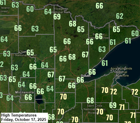
Temperatures climbed into the mid to upper 60s in northeast Minnesota and northwest Wisconsin today, with some spots even hitting the low 70s. These readings are roughly 15 degrees above the average for October 17th.
This weekend will bring cooler temperatures, with highs reaching the 50s to lower 60s on Saturday and dropping to the 40s and 50s on Sunday. However, these temperatures are much more typical for this time of year compared to today’s weather.

The winds picked up today due to a deep low-pressure system, around 988mb, located over eastern Manitoba. Wind gusts in parts of the Northland reached speeds of 25 to over 30 mph.
Breezy conditions will persist through Sunday, but it won’t be as windy as today. Wind gusts are expected to reach around 15 to 20 mph on both Saturday and Sunday.

Here’s a look at today’s system moving northeast into western Ontario, and it’s a powerful one.
GOES-19 water vapor loop ending at 5:50 PM CT on Friday, October 17, 2025.

In the past 24 hours, there have been significant rainfall totals across far northern Minnesota, western North Dakota, eastern Montana, and another area extending from central Nebraska into parts of southeastern South Dakota.
The latest system brought a significant contrast in rainfall, with International Falls receiving 1.55 inches, while Duluth only got 0.06 inches.

No rain is expected in northeast Minnesota and northwest Wisconsin this weekend. However, some rain might return next week during the Monday-Tuesday timeframe as a strong trough and an area of low pressure move through the Upper Midwest and western Great Lakes. At the moment, rain amounts with that system don’t appear to be very significant.
Far northern Minnesota may see around a quarter to perhaps a half inch of rain with the system early next week, with lower amounts of rain expected farther south. However, another area that may see higher rain amounts would be locations east of Ashland in northwest Wisconsin.

Leave a Reply