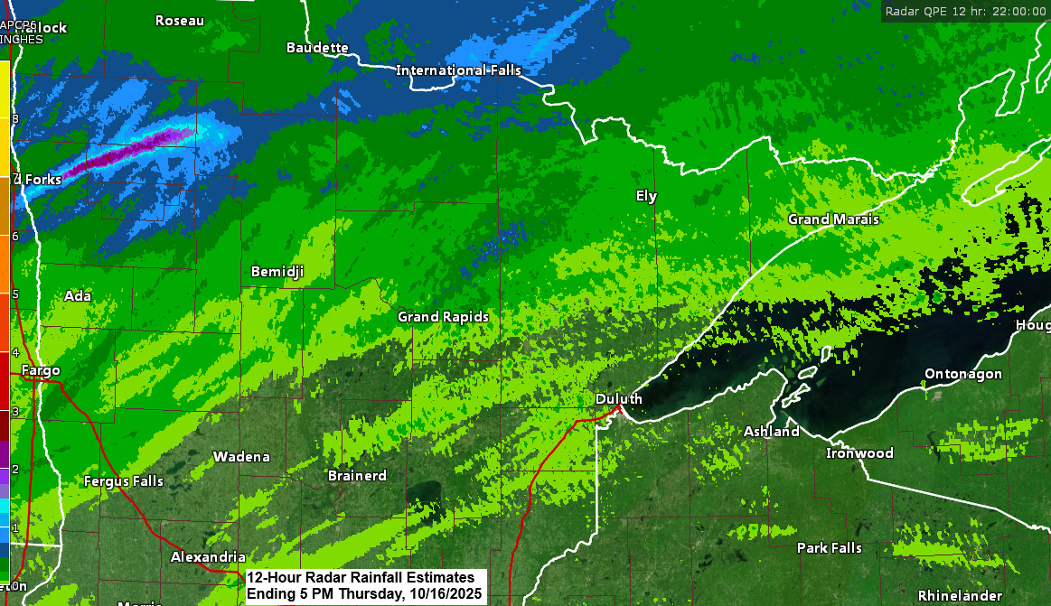
Far northern Minnesota saw some significant rainfall today, which was predicted quite accurately by the computer models, while a lot less rain fell farther south across other parts of the Northland.
International Falls set a new precipitation record for October 16th, with 1.41 inches of rain recorded so far today. This surpasses the previous record of 1 inch, which was set in 1984.
Rainfall Reports for October 16, 2025, as of 6 PM
- International Falls, MN: 1.41″
- Littlefork, MN: 1.19″
- Cook, MN: 0.33″
- Orr, MN: 0.25″
- Bigfork, MN: 0.24″
- Northome, MN: 0.18″
- Winton, MN: 0.15″
- Keewatin, MN: 0.13″
- Grand Marais, MN: 0.13″
- Walker, MN: 0.08″
- Cass Lake, MN: 0.08″
- Isabella, MN: 0.07″
- Hibbing, MN: 0.06″
- Eveleth-Virginia, MN: 0.06″
- Schroeder, MN: 0.06″
- Ely, MN: 0.04″
- Grand Rapids, MN: 0.04″
- Brainerd, MN: 0.03″
- Moose Lake, MN: 0.02″
- McGregor, MN: 0.02″
- Saginaw, MN: 0.01″
- Duluth Airport: 0.01″
- Esko, MN: 0.01″
- Poplar, WI: 0.01″
- Danbury, WI: 0.01″
The weather system that affected California earlier this week has now reached the northern Plains and will continue moving northeast through Saturday.
A warm front linked to a low-pressure system over North Dakota will move northeast across the Northland tonight, followed by a cold front sweeping through the area on Friday.
Scattered showers will persist across northeast Minnesota and northwest Wisconsin tonight, with the chance of an isolated thunderstorm due to pockets of elevated CAPE lingering in the area this evening.
Rain chances will diminish from Friday through the weekend, though a few showers may still occur on Friday or Saturday.
GOES-19 water vapor loop concluding at 5:30 PM CT on Thursday, October 16, 2025.

Tonight, far northern Minnesota could see additional rainfall of 0.1 to 0.25 inches, while other parts of the Northland may receive lighter amounts, ranging from just a trace to about 0.15 inches.

A strong upper low lingers over the Atlantic, just off the northeast U.S. coast, while another powerful trough is positioned over the Rockies. Between these two troughs lies an upper-level ridge, with an additional ridge situated over the Pacific, just off the western U.S. coast.

Temperatures climbed into the 70s this afternoon across the southwestern half of Minnesota, eastern South Dakota, and southeastern North Dakota. Even farther north and east, while cooler, temperatures remained above average for mid-October.

Colder air might move into the upper Midwest by the middle of next week as a strong trough and low-pressure system pass through the area. Daytime temperatures could stay in the 40s on Tuesday and Wednesday in northeast Minnesota and northwest Wisconsin. However, this cold spell doesn’t seem like it will last long, with temperatures likely to moderate by late next week.

Leave a Reply