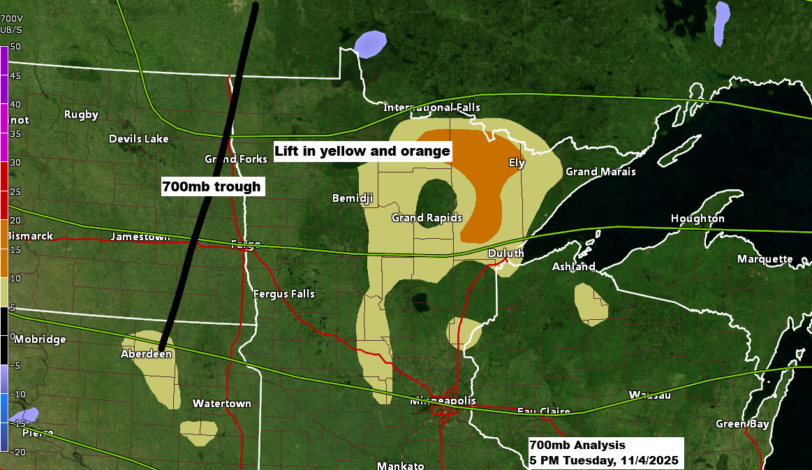
A broad low-pressure area and a trough will move eastward out of western Minnesota tonight. This system is expected to bring some precipitation to northeast Minnesota and northwest Wisconsin, followed by a return to dry weather on Wednesday.
Radar loop ends 5 PM Tuesday, November 4, 2025.
Most of the precipitation tonight will be rain, as temperatures remain in the mid-40s across far northern Minnesota this evening. Additionally, 850mb temperatures are above 0°C, ranging from about +1°C to +3°C.
It could take some time, but there’s a possibility that temperatures both higher up and at the surface might drop enough to change rain into snow in far northern Minnesota late tonight or early Wednesday morning. This, however, depends on whether enough cold air arrives before the precipitation moves away.

I kept my snowfall forecast from Monday evening unchanged for early Wednesday morning. However, it’s a low-confidence forecast, and I believe areas that might transition to snow late tonight likely won’t get more than a few tenths of an inch of accumulation.
Note: No snow is forecasted for Duluth early Wednesday morning.

Tonight’s system is expected to bring the most precipitation to northern Minnesota and the Arrowhead region, with totals around 0.1 to 0.25 inches. Farther south, including Duluth and northwest Wisconsin, amounts are likely to range from just a trace to about 0.05 inches.

NAM 3km model simulated radar forecast through 6 AM Wednesday.
Rain (green)
Snow (blue)
Note: Rain chances in Duluth are highest later this evening after 9 PM, diminishing early Wednesday morning before 5 AM.

Another fast-moving system will pass through the Northland from Thursday to early Friday, bringing some rain and snow showers primarily to northern Minnesota. However, no significant amounts of snow or rain are expected.

The system I’ve been monitoring for Saturday has shifted much farther south on the Euro and Canadian models today, and these more southern trends now align closely with the GFS model, which has been showing a southerly track for several days.
This means it’s unlikely that northeast Minnesota or northwest Wisconsin will see any snow from the clipper system on Saturday. However, an upper low or trough approaching from the north (highlighted in dark red) could bring some snow showers and flurries to the Northland over the weekend, though any accumulation would probably amount to just a light dusting.
Temperatures are expected to be much colder in the Northland this weekend and early next week, with highs reaching only the 20s and 30s and lows dropping into the teens and 20s.

The arctic air to our north is really intensifying today, with temperatures ranging from the single digits and teens below zero to the teens above zero.
Eureka, Nunavut, Canada experienced a temperature of -27 degrees with a wind chill of -51 degrees this afternoon. Typically, the normal high for November 4 in Eureka is -9, and the normal low is -17, making this an exceptionally chilly day for early November.

…Fall Temperature Update…
While average temperatures this fall are warmer than usual in Duluth and across the Northland, fall 2025 in Duluth is actually 3.2 degrees cooler compared to fall 2024 as of November 3.
| Average temperature and deviation from normal between September 1 and November 3, 2025. Brainerd, MN Average: 55.5 degrees Departure: +4.3 degrees above normal Superior, WI Average: 55.0 degrees Departure: +3.6 degrees above normal Cass Lake, MN Average: 54.5 degrees Departure: +5.1 degrees above normal Two Harbors, MN Average: 53.1 degrees Departure: +1.9 degrees above normal Duluth, MN Average: 53.0 degrees Departure: +3.1 degrees above normal Grand Marais, MN Average: 52.4 degrees Departure: +4.3 degrees above normal Cloquet, MN Average: 52.4 degrees Departure: +3.5 degrees above normal International Falls, MN Average: 51.9 degrees Departure: +5.0 degrees above normal Embarrass, MN Average: 51.6 degrees Departure: +5.6 degrees above normal Hibbing, MN Average: 51.4 degrees Departure: +5.6 degrees above normal |
This fall, average temperatures across northeast Minnesota and northwest Wisconsin have been running about 2 to 5 degrees warmer than usual.

Leave a Reply