Accumulating snow is on the way.
Snow on Monday will mainly fall in the afternoon and evening, moving from west to east across the Northland. A few scattered flurries or snow showers might pop up earlier in the day, but any accumulation would be minimal, with the best chance for measurable snow coming from mid to late afternoon into the evening.
Snow on Monday will come from a clipper system moving east out of North Dakota.
A brief period of stronger lift is expected to pass through the Northland Monday evening, which could bring moderate snowfall rates lasting 1 to 3 hours in any given spot. The snow is expected to ease up late Monday night.
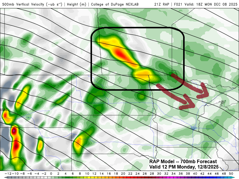
The RAP model 700mb forecast shows yellow, orange, and red areas on the loop, signaling stronger atmospheric lift that could bring heavier bursts of snow to the Northland on Monday evening.

Duluth: Most of the snow will arrive Monday evening, mainly after 6 PM, and will taper off late that night around midnight.
RAP model simulated radar forecast valid 12 PM Monday to 1 AM Tuesday.

…Here’s my snowfall forecast for Monday’s system…
Generally looking at a range between 1 and 3 inches of snow, and this should be a fluffy snowfall once again.
The North Shore could get a bit more snow, topping 3 inches, thanks to some lake effect from southerly winds blowing across Lake Superior.

A second clipper system, likely stronger than Monday’s, could bring a sub-990mb low moving southeast out of southern Saskatchewan on Tuesday.
Computer models disagree on the track of this low, with some showing it moving farther north, roughly along the I-94 corridor in central Minnesota, while others have it taking a more southern route.
If the low takes a more northerly path, there’s a better chance for several inches of snow across much of northeast Minnesota and northwest Wisconsin, including Duluth. But if it shifts south, the odds of getting significant snowfall in those areas, Duluth included, would likely drop.
Snow totals will depend on the path of the low, but there’s a chance for a band of about 2 to 5 inches or more to hit parts of northeast Minnesota and northwest Wisconsin from Tuesday afternoon into Tuesday night.
Stay tuned

…Weather Alerts…
- A Winter Weather Advisory is in effect for the North Shore of Lake Superior in northeast Minnesota on Monday and Monday night.
- Tuesday’s forecast includes a winter storm watch for the areas marked in blue, along with a high wind watch in the orange-colored regions, where wind gusts could reach up to 65 mph.

Make a one-time donation
Make a monthly donation
Make a yearly donation
Choose an amount
Or enter a custom amount
Your contribution is appreciated.
Your contribution is appreciated.
Your contribution is appreciated.
DonateDonate monthlyDonate yearly
Leave a Reply