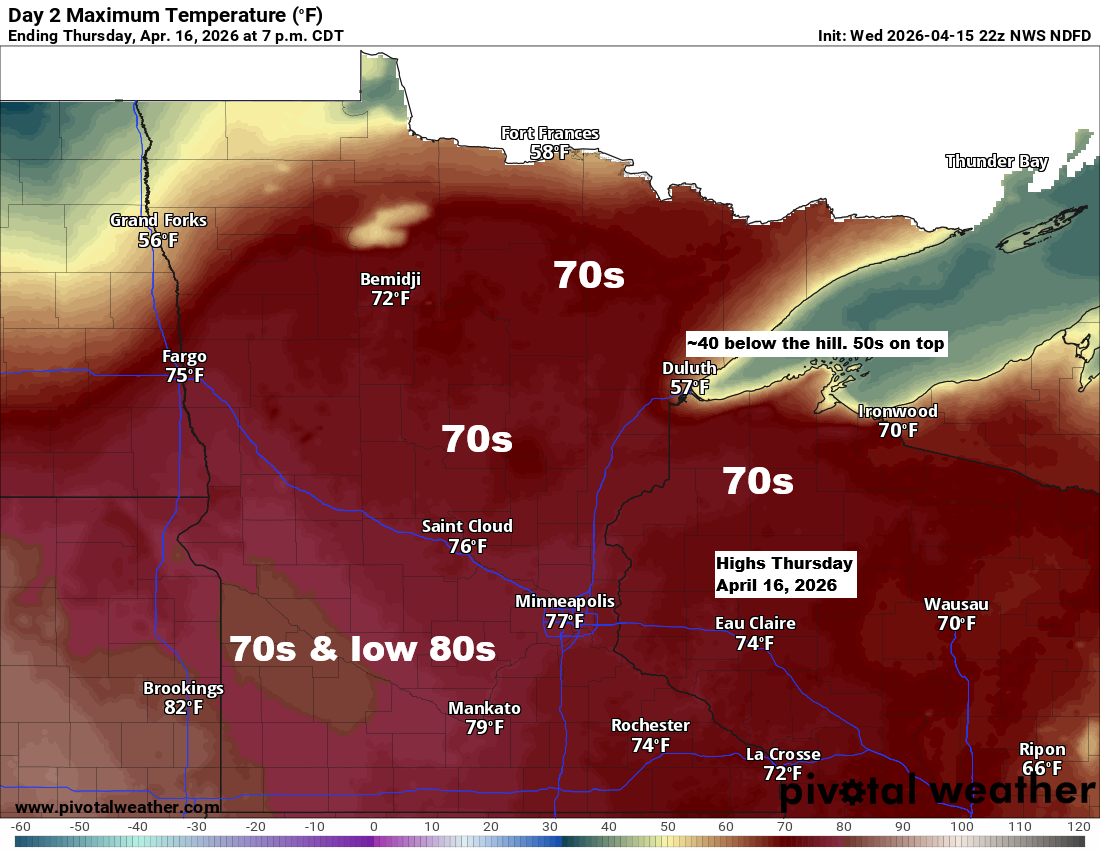
Thursday will bring warm spring weather away from Lake Superior, with highs in the 60s and 70s, and even 80s in southwest Minnesota. However, an east wind will keep temperatures near 40 close to the lake, while the Duluth Airport will see highs in the 50s.
Another round of fog is expected near Lake Superior later tonight, lingering into Thursday morning with visibility dropping to a quarter mile in some areas, before clearing out Thursday afternoon.
What was expected to be an active week of weather in the Northland hasn’t really panned out, as all the heavy rain and stormy conditions have set up farther southeast than originally forecasted.
Over the past 168 hours, ending Wednesday morning at 7 AM CT, rainfall has reached 2 to 4 inches or more across much of Iowa through far northern Illinois, southeast Minnesota, and into southern, central, and eastern Wisconsin, as well as parts of upper and lower Michigan. This area has experienced multiple rounds of heavy rain, thunderstorms, and bouts of severe weather and flooding over the last several days.
Since Saturday, Duluth has only received about 0.27 inches of rain, roughly a quarter inch. Ensemble models had predicted anywhere from 1 to 2 inches or more of precipitation, but so far, those forecasts have been far from accurate.

Precipitation anomalies across the Midwest this month reveal totals reaching 300 to over 400% of the norm, highlighted by lighter blue and purple areas.
It’s been much drier so far this month from St. Louis to Indianapolis to Columbus, down to Louisville, with another area of dry weather stretching from eastern South Dakota into southwest and central Minnesota.

Another shot of rain is possible in the Northland on Friday as a sharp cold front and trough move through, but coverage will be scattered, so not everyone will get much. For those who do, the rain should only last a few hours at most since the front will move through quickly.
It looks like Duluth could get about 0.1 to 0.25 inches of rain, mainly on Friday afternoon, with a chance for higher amounts northeast and east of the city.

A few thunderstorms could pop up in parts of the Northland Friday afternoon, but the timing of this system isn’t ideal for a severe weather threat in our area. Still, an isolated strong storm might produce some hail, though they’re not expected to be widespread.
Once again, the chances of rain in Duluth on Friday peak in the afternoon.
NAM 3km model simulated radar forecast valid 7 PM Thursday to 7 PM Friday.

It was great to finally see some sunshine in Duluth this afternoon after what felt like days of gray, foggy weather. Even so, temperatures stayed cool thanks to a steady wind off Lake Superior, holding near 50 on top of the hill, about average for April 15th, while areas closer to the lake stayed in the upper 30s and 40s.
Away from Lake Superior, it was a beautiful spring day with temperatures in the 60s and even a few spots reaching the lower 70s.

From March 1 to April 14, 2026, average spring temperatures across the Northland ranged from slightly below normal in the far north, shown in green, to slightly above normal in the far south, shown in orange.
Areas shown in white, including Duluth, have been experiencing average temperatures that are pretty close to normal so far this spring.

Leave a Reply