Temperatures in northeast Minnesota and northwest Wisconsin rose sharply this afternoon following a chilly, record-setting cold start to May 11th.
Lows, departures, and records on May 11
***=New daily low temperature record
International Falls, MN
Low: ***19 degrees***
Departure: -17 degrees
Record Low: 21 set in 2020 and 2021
Hibbing, MN
Low: 20 degrees
Departure: -14 degrees
Record Low: 19 set in 1946
Ashland, WI
Low: 25 degrees
Departure: -12 degrees
Record Low: 20 set in 1963
Duluth, MN
Low: 25 degrees
Departure: -15 degrees
Record Low: 23 set in 1946 and 1963
Brainerd, MN
Low: 28 degrees
Departure: -13 degrees
Record Low: 22 set in 1946
In International Falls, the average last day with a low of 19 degrees or colder is April 15, with the latest recorded occurrence on May 17, 1926.
In Duluth, the last day with a low of 25 degrees or colder typically falls on April 22, with the latest recorded date being May 16, 1956.
This afternoon, temperatures climbed into the 50s and low 60s across northeast Minnesota and northwest Wisconsin, which is close to, but still a few degrees below, the average for this time of year. However, east winds off Lake Superior kept areas near the shore stuck in the 40s.
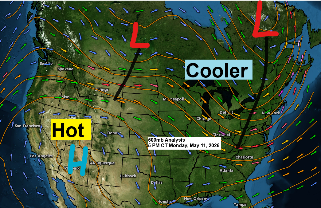
Out west, it’s much warmer, with temperatures in the 80s and even a few spots hitting the 90s. That kind of heat isn’t heading to the Northland anytime soon.

Duluth could reach 70 degrees on Friday for just the second time in 2026, with the first occurrence happening back on April 16th.
If the front clears out Thursday night and the winds shift west, there’s a good chance temperatures could climb to around 70 on Friday, maybe even a bit higher.

…Rain chances tonight and Tuesday…
Tonight, a clipper low will move east-southeast from southwest Manitoba, exiting to the east of the Northland by Tuesday afternoon.
This system doesn’t carry much moisture since it’s a clipper moving quickly down from Canada, but some lift should help produce scattered showers in the Northland late tonight into early Tuesday morning.

Some elevated instability will move east with tonight’s system, possibly sparking a few thunderstorms late tonight across parts of western, central, and southern Minnesota. No severe weather is expected.
The chances of thunder in the Northland are pretty low for late tonight, but it’s not completely out of the question.

As the mid and upper-level trough moves over the Northland Tuesday afternoon, it will bring colder air aloft, which should help trigger a few more showers. These showers will probably be spotty in coverage and fairly brief.

In Duluth, the highest chance of rain is early Tuesday morning, mostly before 7 AM, with a few showers possibly returning in the afternoon.
NAM 3km model simulated radar forecast through 7 PM Tuesday.

Rainfall anomalies for May 2026, recorded up to 4 PM on the 11th.
Ashland: -1.12 inches
Duluth: -1.09 inches
Brainerd: -0.99 inches
Hibbing: -0.80 inches
International Falls: -0.74 inches

Rainfall could total between 0.05 and 0.25 inches, possibly more, across parts of northeast Minnesota and northwest Wisconsin through Tuesday afternoon.
The last time Duluth got a quarter inch or more of rain was April 27, when 1.36 inches fell. Tonight’s system won’t bring us an inch, but we might see up to a quarter inch.

Another round of gusty winds will blow across much of the Northland following tonight’s clipper, with west to northwest winds picking up and gusting between 15 and 30 mph in northeast Minnesota and northwest Wisconsin. These winds will build from west to east throughout the day on Tuesday.
Note: Gusty west-northwest winds, blowing at 15 to 30 mph, will sweep into Duluth on Tuesday afternoon.

…Long Range Trends…
It looks like the weather pattern in the upper Midwest will be getting more active, with a couple of systems possibly bringing rain to northeast Minnesota and northwest Wisconsin over the next two weeks.
After tonight’s system, another front is expected to move through the area Thursday night, possibly bringing a few showers to the Northland. Then, a larger system could bring rain to the region sometime Sunday into Monday (May 17–18).
The EPS and GEFS ensemble models are predicting rainfall totals of 1 to 2 inches through May 26.


Leave a Reply