Two cold fronts will sweep across the Northland by Friday. The first arrives Thursday, moving slowly as it pushes east from western Minnesota in the morning and exits to the east by Friday morning. Hot on its heels, a second cold front will pass through the area later on Friday.
Even with these fronts moving through, rain chances don’t seem particularly high. We’ll likely get some passing showers, isolated to scattered, on Thursday and again Friday, but many of us might not see much rain at all through the end of the week.
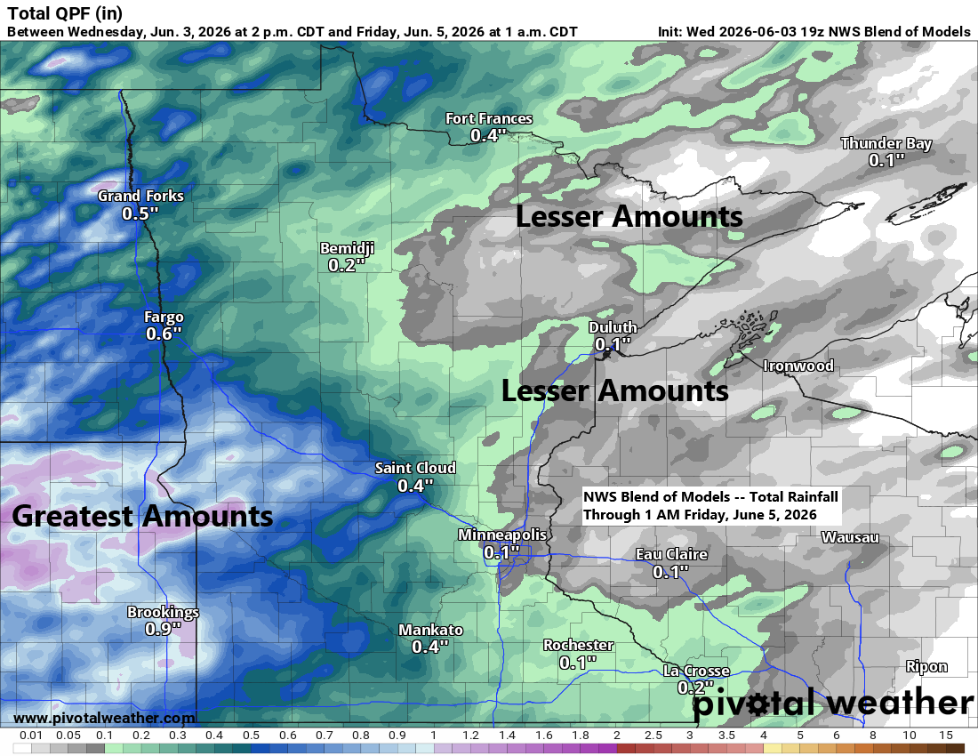
Rainfall in northeast Minnesota and northwest Wisconsin through Thursday evening will vary, as it often does this time of year. Some spots in the Northland could pick up between 0.10 and 0.25 inches, while others might only see a trace to about 0.10 inches.
If we get some rain in Duluth on Thursday, it’s most likely after 4 AM and through mid-morning. There’s also a chance for more showers to pop up in the afternoon and evening, but the computer models are all over the map—some show it staying completely dry, while others have scattered showers and storms in the area.
HRRR model simulated radar forecast through 10 PM Thursday.

To our west, where instability and shear are higher, there’s a risk of severe thunderstorms tonight, with a tornado watch in effect for eastern North Dakota, far western Minnesota, and central and eastern South Dakota.
No severe weather is expected tonight in northeast Minnesota or northwest Wisconsin, though an isolated stronger storm with hail and gusty winds could pop up Thursday afternoon into early evening, mainly in northern Wisconsin and far eastern Minnesota. Widespread strong or severe thunderstorms aren’t expected on Thursday or Friday.

Moisture will move northeast ahead of these fronts, with dew points in parts of the Northland climbing into the 50s on Thursday and possibly reaching the lower 60s in the southern areas.
About a week from now, computer models suggest the possibility of a tropical-like airmass moving north into our area by mid to late next week, potentially bringing dew points in the 60s and 70s. Time will tell if it actually plays out.

The weather pattern is shifting today, with the large ridge that stretched from central Canada to the Great Lakes starting to break down as an upper-level trough moves in from the west.

There’s quite a mid and upper-level low, with noticeable spin, over southern Saskatchewan today. It’s all part of the same trough pushing east into the upper Midwest.
Goes-19 water vapor loop ending 5:20 PM CT Wednesday, June 3, 2026.

Highs in northeast Minnesota and northwest Wisconsin reached the 70s to low 80s today, but no records were broken due to a bit more cloud cover than anticipated.
Duluth hit its first 80-degree day of the month today. On average, June sees about five days reaching 80 degrees.
Highs from Thursday through the weekend will stay steady in the 70s and 80s across the Northland, though occasional lake winds through Sunday may keep temperatures in the 50s and 60s near Lake Superior.

Leave a Reply