One of the most favorable setups for strong and severe thunderstorms in the Northland this spring is expected to arrive on Wednesday.
A strong mid- and upper-level trough will quickly move northeast out of the northern Plains, with strong divergence and southwest winds aloft creating plenty of lift in the atmosphere.
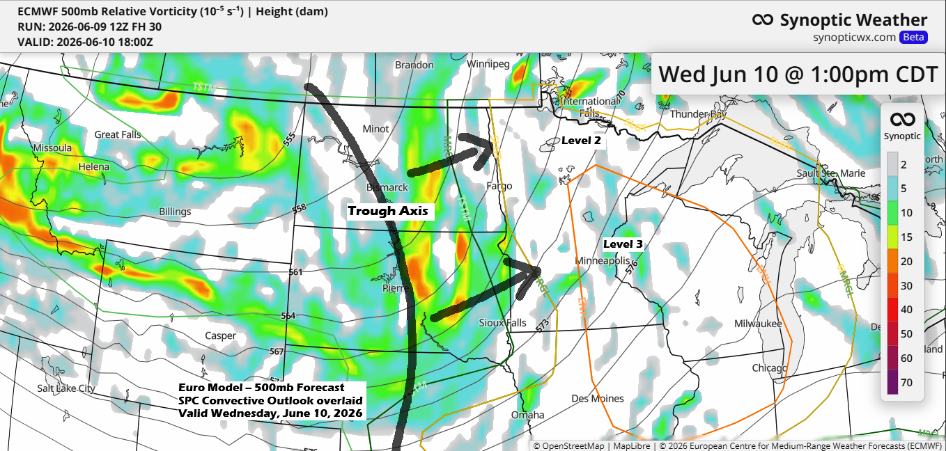
On Wednesday, a warm front will head northeast from western and southern Minnesota, followed by a cold front pushing in from the west. This setup could bring multiple rounds of showers and thunderstorms to the Northland—one in the morning, and another from mid-to-late afternoon into the evening. The later storms may carry the greatest risk for severe weather in parts of the region.
There are issues in the Wednesday forecast. One problem occurs if clouds remain or if scattered storms continue to develop during the day, preventing a break that would let moisture and instability move northeast from southern Minnesota in the afternoon.
Right now, it seems the first round of storms will move out of the Northland early in the morning, leaving several hours of partial clearing. That break should help recharge the atmosphere for another round of storms later Wednesday afternoon.
One lingering question about Wednesday afternoon and evening’s forecast is what kind of storm mode we’ll see in our area. Will the storms stay as discrete supercells, boosting the chances for very large hail (golf ball size or bigger), damaging winds, and isolated tornadoes? Or will they quickly organize into lines, which would lower the tornado risk but still bring the possibility of hail and strong winds? With the amount of forcing moving into the area with the upper trough, the latter scenario seems more likely than the first, but we’ll see.
Note: In the Duluth area, showers and thunderstorms might roll through early Wednesday morning, sometime between 3 and 7 a.m.
This is the NAM 3km model forecast for 2 AM on Wednesday.

Tonight, the severe thunderstorm risk in the Northland ranges from level 1 to 2, while on Wednesday it’s at a level 2 or 3, depending on which part of the area you’re in.

…Tonight’s risk…
Strong to severe thunderstorms are likely to form tonight across the Dakotas, with a tornado watch in effect for much of the area until late tonight.

Storms forming over the northern Plains are expected to move quickly northeast, passing through parts of the Northland early Wednesday morning.
While the highest risk for severe weather is farther west, a few storms could become severe as far east as International Falls, Grand Rapids, and McGregor, including the Brainerd Lakes area. Early Wednesday morning, winds up to 60 mph and quarter-size hail (1″ diameter) will be the main threats in the western parts of the Northland.

…Wednesday’s risk (6/10)…
All of the Northland is under either an Enhanced or Slight risk for severe thunderstorms on Wednesday.

The main takeaway from the two forecasts below is that scattered storms are expected to redevelop across the Northland on Wednesday afternoon, continuing into the evening, with the threat ending from west to east by mid to late evening.
Here’s the HRRR model forecast for Wednesday at 4 PM.

And the NAM 3km model forecast for 4 PM Wednesday.

Northeast Minnesota and northwest Wisconsin can expect up to half an inch of rain through Wednesday evening, with some spots seeing over an inch.

…Dense Fog tonight…
Dense fog is expected to return near Lake Superior tonight and linger into Wednesday morning, with visibility dropping to a quarter mile or less.

This afternoon, high temperatures climbed well into the 80s in northeast Minnesota and northwest Wisconsin, while areas closer to Lake Superior saw cooler readings ranging from the 50s to 70s. The coolest spots were within about 10 to 15 miles of the lake, as the lake breeze was a bit weaker than it has been in recent days.
Highs on Wednesday are forecast to be in the 70s and 80s in northeast Minnesota and northwest Wisconsin with 50s near Lake Superior.

There’s plenty of moisture in the air again today, with dew points staying in the 60s to near 70 degrees across much of the Northland. These muggy conditions will hang around for one more day on Wednesday.

Leave a Reply