A round of showers and thunderstorms moved northeast through the Northland early this morning, and scattered storms have redeveloped as expected this afternoon. Fortunately, we haven’t seen much in the way of severe weather with this system today, and it looks like that will remain the case before it moves out of the area later this evening.
That said, there’s still a chance for a few strong to severe thunderstorms in our area through mid-evening, with gusty winds and hail as the main threats.
Overall, the forecast played out well today with the predicted separate round of storms, but the absence of severe weather is still a bit puzzling given the ingredients that were in place.
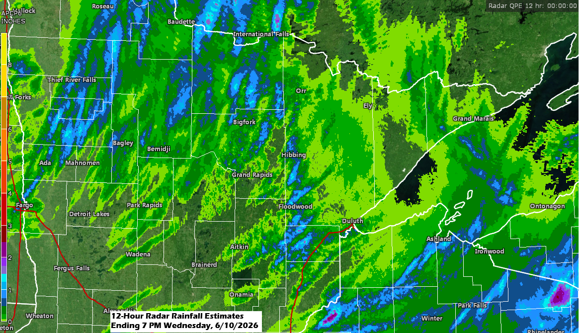
Note: Rainfall in the Twin Ports area today ranged from about a quarter to half an inch, with 0.30 inches recorded at the Duluth Airport and 0.52 inches at the Superior Airport.
…Radar Trends…
Showers and thunderstorms will clear out from west to east across the area by late this evening.
Radar loop ends 7:08 PM Wednesday, June 10, 2026.
Yellow polygons – Severe Thunderstorm Warning
…Early Wednesday morning storms…
This is how the early morning storms appeared on infrared satellite imagery from GOES-19.

…Wednesday afternoon storms…
Here’s a glimpse at the widespread thunderstorm activity from this afternoon, shown by the brighter white cloud tops.
Goes-19 visible satellite loop ending 5:50 PM CT Wednesday, June 10, 2026.

…Today’s storm setup 6/10…
A fairly strong trough moved northeast out of the northern Plains today, bringing plenty of divergence ahead of it as winds shifted from southwest to south.

At the surface, a strong low-pressure system sits over eastern Manitoba, with a central pressure down to 991 mb, or 29.26 inches. A cold front linked to this low is lifting northeast out of central Minnesota, bringing plenty of convergence near and ahead of it this afternoon.

This system has brought widespread strong to severe thunderstorms today, with several severe thunderstorm watches (yellow) and a tornado watch (red) in effect through this evening.

Today’s trough has brought widespread thunderstorms to the upper Midwest and Great Lakes, and if you look closely, you can even spot some blue on the radar, signaling snow in the higher elevations of western Montana and northwest Wyoming.
Radar loop ends 5:54 PM CT Wednesday, June 10, 2026.
Tornado warning – red
Severe thunderstorm warning – yellow
Flash flood warning – green
…Thursday rain chances…
We might see a few more showers in parts of the Northland Thursday into Thursday evening as another wave/trough moves over the upper Midwest. Instability will be much lower in our area, so widespread thunderstorms aren’t expected, but a few isolated storms could still pop up.

NAM 3km model simulated radar forecast valid 7 AM to 7 PM Thursday.

Here’s a look at the NBM (National Blend of Models) rainfall forecast, valid from 2 a.m. Thursday to 7 a.m. Friday.
Some areas in northeast Minnesota and much of northwest Wisconsin might get about 0.05 to 0.25 inches of rain on Thursday.

Leave a Reply