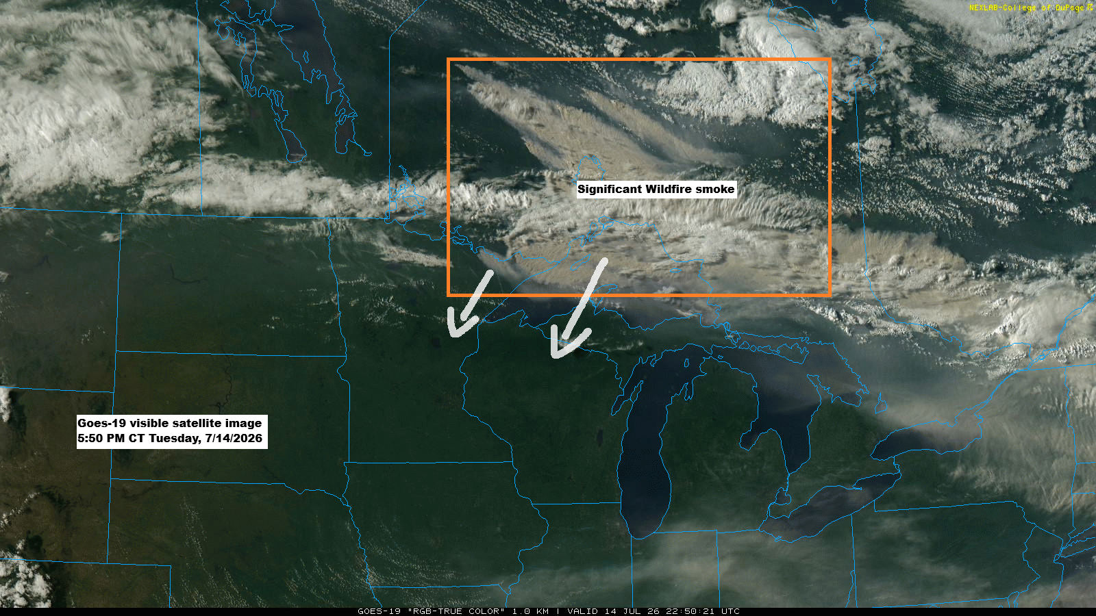
GOES-19 satellite images show thick plumes of wildfire smoke drifting from parts of Ontario into far northeast Minnesota and over Lake Superior this afternoon, mixing with some clouds. The smoke is expected to move southwest across the Northland, with air quality likely to worsen overnight into Friday morning. The smoke is forecast to reach the Twin Ports area late tonight, around or just after midnight.
So far, we’ve been pretty lucky with decent air quality across much of the Northland this summer, but that’s about to change in a big way tonight and over the next few days as thick wildfire smoke spreads across the region, moving southwest from the Arrowhead of Minnesota.
Air quality is expected to hit hazardous levels in the maroon zones on the map, with very unhealthy conditions in purple areas and unhealthy conditions in red areas. An air quality alert from wildfire smoke remains in effect until 11 AM Friday.

A webcam shot from Seagull Outfitters on the Gunflint Trail in Minnesota’s Arrowhead shows the scene on Tuesday afternoon, July 14, 2026. The dark, hazy skies are largely due to wildfire smoke, and similar conditions are expected across other parts of the Northland in the coming days.

…Fire Update, 5:45 PM Tuesday, July 14, 2026…
- Thumb Fire: 14,500 acres. No containment. This fire is between Thumb and Contentment Lake in the BWCAW. The northernmost point of the fire is Twenty-five Island, per air attack.
- Dark Fire/Bear Trap Fire: 12, 896 acres. No containment. This fire is off the Bear Trap River and north of Sunday Lake in the BWCAW.
- Sioux Fire: 3,648.4 acres. No containment. This fire is north of the Echo Trail and east of Jeanette Campground.
- Wolfpack Fire: 2,234 acres. No containment. This fire is about 4 miles north of Co Hwy 116, Superior National Forest.
- Camp Fire: 2,200 acres. No containment. This fire is approximately 8 miles north/northeast of the Cloquet Line near Ely, MN.
There are several other fires burning in addition to those mentioned above; I just listed some of the larger ones.
Note: The temporary evacuation point at the Babbitt Municipal Center will stay open until 9 PM today, July 14, and will reopen at 8 AM on Wednesday, July 15, according to Lake County, MN.
3:34 PM Tuesday 7/14 — Due to multiple fires, the BWCAW is closed. Evacuate to closest entry point ASAP.

Colored areas on the images below
Red – Go – Level 3 – Evacuation order
Yellow – Set – Level 2 – Evacuation warning
Green – Ready – Level 1

Yellow – Set – Level 2 – Evacuation warning

The yellow-outlined area has had a notably dry summer, with rainfall totals coming in 3 to 5 inches below average since June 1st.

…Late week rain chances…
A front moving south across the Northland tonight will shift slightly north and south over the next few days, bringing some chances for rain. The showers look to be fairly scattered, but far northern Minnesota—where it’s been driest this summer and large wildfires are burning—could see a quarter to half an inch of rain by Saturday morning, most likely between Thursday and Friday. Still, a widespread heavy rain event doesn’t seem likely at this point.

…Temperatures…
Temperatures in the Twin Ports climbed into the 90s again this afternoon, with Duluth Sky Harbor Airport hitting 97, Superior Airport reaching 96, and Duluth Airport coming in at 91.
The Twin Ports can expect highs in the 80s on Wednesday, with temperatures in the 70s and 80s on Thursday and Friday. This weekend could bring highs in the 80s to near 90.
Note: Over the next few days, winds shifting to the northeast will cause some cooling within about 15 miles of Lake Superior.

It was another scorcher across the Northland today, with temperatures climbing into the 90s once again.
Over the next few days, temperatures will range from the 70s to 80s, with some areas in northwest Wisconsin and east central Minnesota still seeing highs in the 90s.
Ashland, Wisconsin set a new daily record high for July 14th today, reaching 95 degrees. The old record of 94 was set in both 1969 and 1980.

A much drier airmass will move south from far northern Minnesota tonight, with dewpoints falling from the 60s and 70s into the 50s.

The 500mb analysis still shows a large, expansive ridge stretching from the Rockies to the upper Midwest and Ohio Valley, though its strength has eased slightly since yesterday. Even so, it remains an impressive feature, and over the next few days, it will drift a bit farther south.

Leave a Reply