Today’s blog will take a bit longer to read, about five minutes, as there’s plenty of weather to cover, including fires and heat across the Northland.
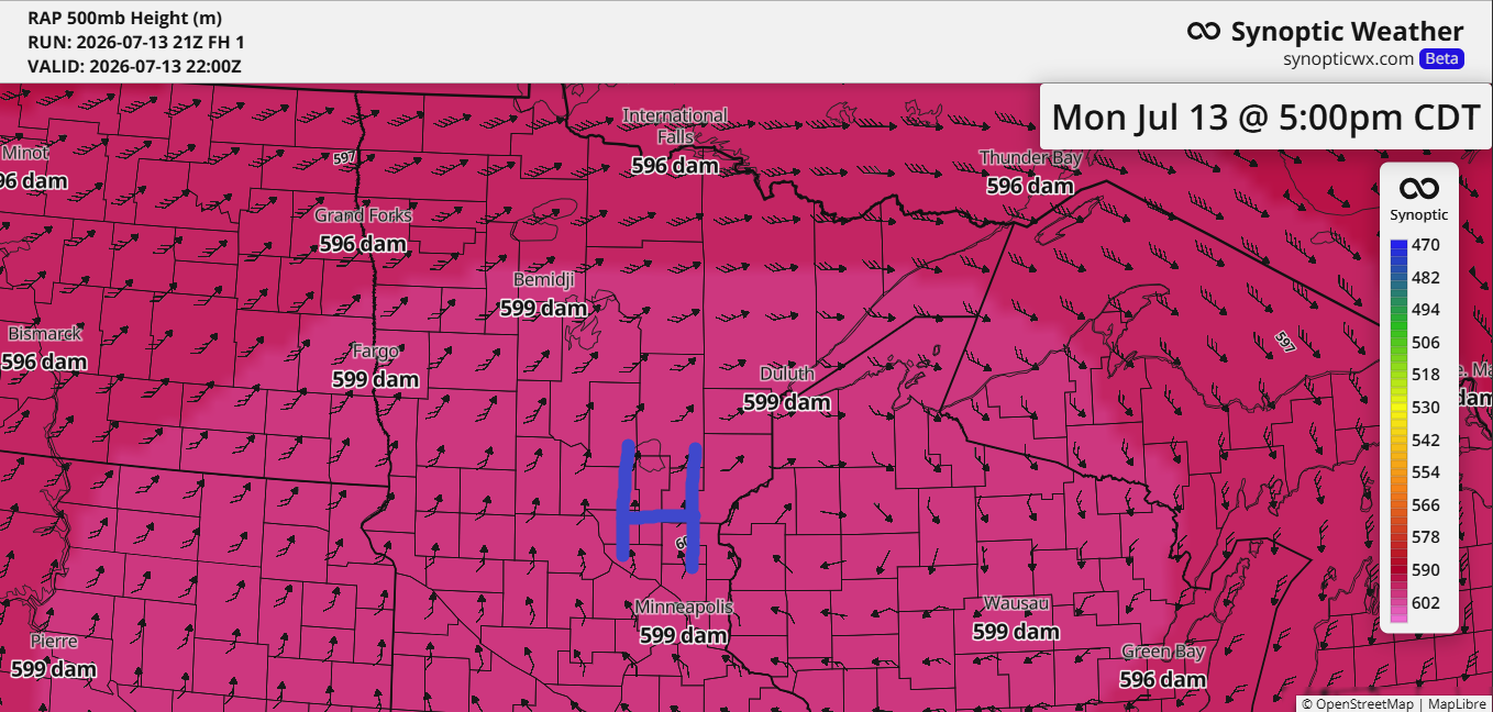
As expected, the ridge over the upper Midwest has reached near-historic levels for this far north, with the RAP model indicating 500mb heights hitting 599 decameters over Duluth, MN this afternoon, and around 600 decameters just a bit farther south.
In the Northland, typical July 500mb heights range from 585 to 590 dam.
Strong ridge: 590-593 dam
High-end ridge: 594-597 dam
Exceptional/near-record: >598 dam
Reaching a 500mb height of 599 dam over Duluth in July is extremely rare—close to the top of the historical range and likely a record-setting ridge for the Northland.
The last time Duluth, Minnesota had three consecutive days with highs of 90 degrees or more was in 2015, from August 13–15, when temperatures hit 90, 93, and 90. Such a streak of heat is pretty uncommon here, but with the current heat wave, Tuesday will likely become the third straight day of 90-degree weather.
On average, Duluth only sees about two days a year when temperatures hit 90 degrees or higher.
…Heat continues Tuesday…
On Tuesday, heat risk remains in the major (red) category across all of northeast Minnesota and northwest Wisconsin, with a few pockets of extreme (purple) scattered throughout.
Highs on Tuesday will range from around 87 to 97 degrees in the Northland, followed by slightly cooler weather mid to late week. Many areas will likely still see temperatures in the 80s, with some possibly hitting the 90s.
East winds are expected to develop near Lake Superior during this time, bringing temperatures down a bit within about 15 to 20 miles of the lake, where patches of fog may occasionally roll in.

…Fire Update 4 PM Monday, 7/13/2026…
Several large fires are still burning today in the orange-outlined area covering far northeast Minnesota and southern Ontario. Smoke plumes from these fires are drifting east, but a cold front moving south through the Northland on Tuesday will shift winds to the north, pushing the smoke farther south. This could bring significant smoke near Lake Superior and into Duluth. The smoke is expected to reach northern areas during the day Tuesday and arrive in Duluth by Tuesday night. It’s unclear how long it will stick around, but it will likely linger at least into Wednesday.

Look of the image above ending 3:36 PM CT Monday, July 13, 2026

A cold front moving south from northern Minnesota on Tuesday will shift winds from the southwest to the north, bringing in a much drier airmass. However, it’s also likely to carry a wave of potentially heavy wildfire smoke into the Northland by midweek.

Northeast Minnesota and northwest Wisconsin, including the fire areas in far northern Minnesota, are expected to see little to no rain through Wednesday. However, some scattered showers may arrive later in the week, bringing around 0.10 to 0.25 inches of rain to the fire zones (marked in yellow on the map) by Saturday morning.
Parts of northwest Wisconsin could see higher totals, mainly from Friday into early Saturday.

The fire situation in far northeast Minnesota is shifting rapidly, but as of late Monday afternoon, just before 4 PM, here’s the latest update.
By Monday afternoon, not one of the fires mentioned below was under control.
- Thumb Fire: 4648 acres
- Camp Fire: 1500 acres
- Dark Fire/Bear Trap Fire: 700 acres
- Sioux Fire: 600 acres
- Wolfpack Fire: 61 acres
- Echo 2 Fire: 14.5 acres
- Marion Creek/Trail Fire: 2.9 acres
-The Camp Fire is burning about 8 miles north-northeast of the Cloquet Line, near Ely, Minnesota.
-The Dark Fire/Bear Trap Fire is burning off the Bear Trap River and north of Sunday Lake in the BWCAW.
-The Thumb Fire is burning between Thumb and Contentment Lake in the BWCAW.

Evacuation alerts as of Monday afternoon, July 13, 2026.
Evacuation order for the Camp Fire
Go (red) – Level 3 – Evacuation Order
*Lake County — North Fall Lake – 1
Set (yellow) – Level 2 – Evacuation Warning
*Lake County — East Winton, Moose Lake, North Fall Lake – 2, Ojibway Lake, Snow Bank Lake, South Fall Lake, West Winton.
*St. Louis County — SL-200
Ready (green) – Level 1
*Lake County — BWCAW Clear Lake, North Silver Rapids, South Silver Rapids
*St. Louis County — SL-201

Zones in yellow on the maps below indicate Level 2 evacuation warnings or set status
Zones in green on the maps below indicate Level 1 or ready status

An Air Quality Alert for wildfire smoke is in effect from 7 AM Tuesday to 11 AM Thursday in northeast Minnesota, with very unhealthy conditions expected in the purple-shaded areas on the map. The alert could be extended farther south in the coming days.

…Temps Monday afternoon 7/13/2026…
Northeast Minnesota and northwest Wisconsin are baking in the heat today, but what really stands out is the yellow-highlighted area where multiple spots are hitting 100 degrees or more this afternoon—pretty extreme for such a northern region. Even Thunder Bay, Ontario, Canada, has climbed to an impressive 102 degrees.

One reason temperatures may have hit 100 in far northern Minnesota today is the mixing of drier air, which dropped dew points into the 50s this afternoon, compared to the muggier 60s and low 70s farther south.

…New record for warm low temperatures set on July 12, 2026…
Duluth, MN
New record: 71
Old record: 70 set in 1892
International Falls, MN
New record: 71
Old record: 69 set in 1898
Ashland, WI
New record: 68
Old record: 67 set in 2018
Hibbing, MN
New record: 68
Old record: 67 set in 1942
…New daily record highs set today, July 13th…
International Falls, MN
New record: 96
Old record: 93 set in 1983
Hibbing, MN
New record: 93
Old record: 92 set in 1983
Leave a Reply