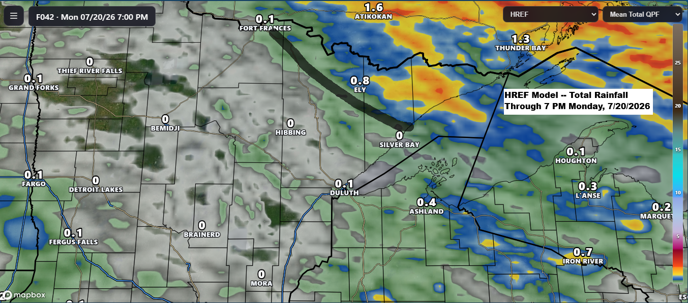
Scattered rain is on the way for the Northland as a strong low-pressure system moves east today from Saskatchewan and into Ontario by Monday. A warm front and cold front tied to this system will sweep through the Northland on Monday.
Ahead of this system, south winds will draw moisture north, with dew points climbing into the 60s to around 70 today and Monday. The lift from the approaching fronts will help spark a few rounds of scattered showers and thunderstorms from this afternoon through Monday.
It looks like far northern Minnesota and the Arrowhead region could see the heaviest rain from this system, with amounts ranging from a quarter to half an inch, and localized totals up to an inch possible by Monday afternoon. Rainfall amounts appear to be somewhat lighter farther south in our area.
In Duluth, the best chance for rain is early Monday morning, mostly before 8 AM. Today, Sunday, should stay mostly dry.
…Severe Thunderstorm Potential…
The timing of the frontal passages isn’t looking great for severe weather in northeast Minnesota and northwest Wisconsin, as the fronts should move through most of the area by mid-afternoon Monday. Still, a few stronger storms could pop up tonight in north central Minnesota, with strong winds of 40–60 mph being the main concern. On Monday, a couple of stronger storms might develop in far northeast Minnesota and parts of northwest Wisconsin, bringing the potential for strong winds of 40–60 mph and hail up to ping pong ball size (1.5″ in diameter).
HRRR model simulated radar forecast valid 3 PM Sunday to 7 PM Monday.
Heat Risk today (Sunday, July 19)
Today’s highs are expected to reach the 80s to around 90 degrees in northeast Minnesota and northwest Wisconsin, though it’s unlikely any of the record highs listed below will be broken.
Record highs for July 19
International Falls, MN: 100 set in 1923
Brainerd, MN: 96 set in 1932
Ashland, WI: 95 set in 1934
Duluth, MN: 94 set in 1901
Hibbing, MN: 91 set in 1957 and 1977
Much of northeast Minnesota and northwest Wisconsin faces a moderate (orange) risk for heat-related impacts today, with a few pockets at major (red) risk, while the North Shore area is seeing minor (yellow) risk.


…Smoke trends…
Wildfire smoke hangs over the Northland this morning, with the worst conditions in the red and purple zones on the map below.
This morning in Duluth, AQI levels are in the orange range, indicating air quality that’s unhealthy for sensitive groups, with values hovering between 119 and 132.


Air quality in Duluth is expected to improve today as southwest winds pick up, carrying most of the smoke farther east.
Forecast of near-surface smoke density based on the HRRR model.
2 PM Sunday, 7/19

Some smoke could shift a little farther west again tonight mainly affecting the Arrowhead and parts of northwest Wisconsin.
12 AM Monday, 7/20

As the warm and cold fronts move across the Northland on Monday, they might bring another wave or two of smoke through the area, though at the moment it doesn’t seem like it will be anything too significant.
1 PM Monday, 7/20

Leave a Reply