Tonight, northern Minnesota can expect showers and thunderstorms, with some heavy rain and a chance of isolated flash flooding as the storms move slowly due to weak winds aloft. More scattered showers are likely on Friday thanks to a low over Iowa and a cold front in the area, but the weekend should bring dry weather.
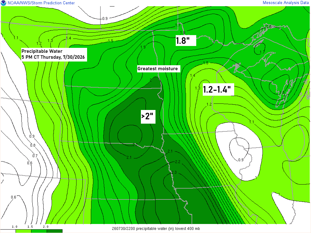
Plenty of moisture is in place to fuel a heavy rain threat across parts of northern Minnesota tonight, with precipitable water levels topping 1.5 inches. A few stronger storms could pop up, especially this evening, bringing the chance for winds up to 60 mph and hail up to about a quarter in size.
Radar loop ends 5:45 PM Thursday, July 30, 2026.
A heartfelt thanks to everyone who has made a donation.
I’m grateful for everyone who reads, shares, and supports this space. It means a lot.
Make a one-time donation
Make a monthly donation
Make a yearly donation
Choose an amount
Or enter a custom amount
Your contribution is appreciated.
Your contribution is appreciated.
Your contribution is appreciated.
The setup remains the same as yesterday, with a cold front slowly moving southeast across the Northland through Friday before finally pushing south by Saturday morning. This will bring in a much less humid airmass for the weekend, along with cooler temperatures, while an area of low pressure moves east-southeast across Iowa on Friday.

Computer models vary on how much rain Duluth might get through Friday afternoon. The Euro model shows it staying dry the whole time, with the rain mostly targeting areas in every direction except over and near the Twin Ports tonight and Friday.
The RAP model, on the other hand, shows Duluth picking up just over a quarter inch of rain by Friday evening, with heavier totals staying to the north and south of the Twin Ports, which is pretty similar to the Euro’s forecast for this event.
Note: The chances of rain in Duluth tonight seem pretty low, and if we do get any, it’ll likely be during the day Friday. Still, I doubt we’ll see much from this system, but we’ll just have to wait and see.
Northern Minnesota could get between half an inch and over an inch of rain tonight, while farther south, from western to southern Minnesota, rainfall totals of 1 to 3 inches are possible by Friday evening, with some spots seeing even more.


Temperatures in the Duluth area reached the upper 80s to around 90 degrees today, but cooler weather is on the way starting Friday and lasting through the weekend, with highs mainly in the 70s. Easterly winds are expected from Friday to Sunday, which could make it feel even a little cooler near Lake Superior.

A glimpse at today’s high temperatures across the Northland on July 30, 2026.

Leave a Reply