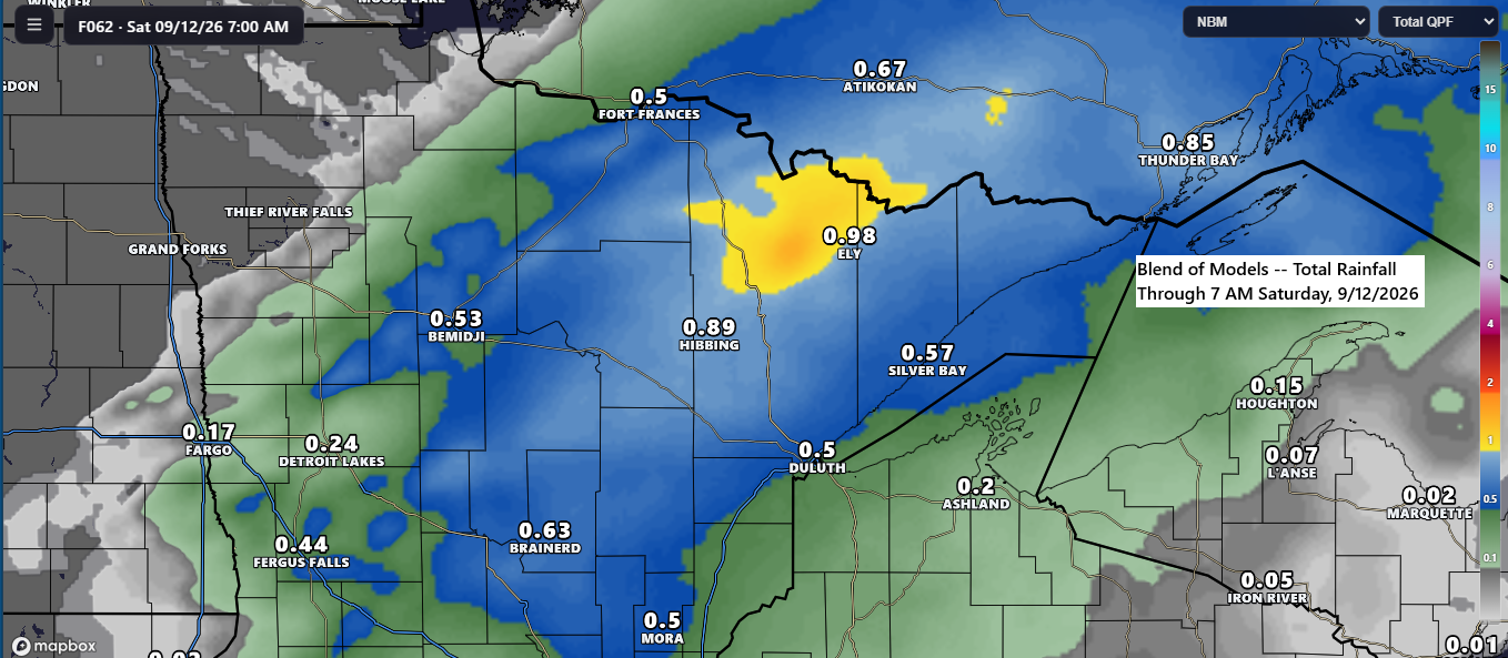
The next opportunity for showers and thunderstorms in the Northland is expected Friday mid to late afternoon into Friday night, as a cold front moves east from western Minnesota accompanied by a low-pressure system forecast to track northeast from South Dakota.
Rainfall from late Friday afternoon through Friday night could range from a half inch to an inch across much of northeast and north central Minnesota, while northwest Wisconsin is generally expected to see around a quarter inch or less. These amounts may vary slightly over the coming days.
Ahead of this system on Friday, a southwesterly low-level jet is expected to strengthen to around 30 to 45 knots, enhancing the warm air and moisture advection pattern on Friday.

Dew points are expected to climb into the upper 50s and low to mid-60s across the area Friday afternoon and evening, providing sufficient moisture for thunderstorm development and the potential for some severe weather.

On Friday, CAPE is expected to reach 750–1500 J/kg in northeast Minnesota and northwest Wisconsin, with mid-level lapse rates near 7.0 °C/km, creating favorable conditions for thunderstorms and possible severe weather.

All of northeast Minnesota and northwest Wisconsin are under a risk for a few severe thunderstorms Friday afternoon and evening, with the yellow-shaded area indicating a level 2 out of 5 and the dark green area a level 1 out of 5 for severe storms.
Damaging wind gusts up to 60 mph and large hail reaching half-dollar size (1.25″ diameter) are expected to be the primary severe weather threats in our area later this week.


The intense low over Manitoba on Tuesday has moved rapidly northeast, reaching the eastern shores of Hudson Bay in Canada today. Meanwhile, earlier this morning, a potent trough crossed northern Minnesota and by late afternoon had reached the Ontario–Quebec border, making the overall pattern quite progressive.
Goes-19 water vapor loop for Wednesday, September 9, 2026, from 6:35 AM to 6:25 PM CT.
The region experienced strong winds today, with recorded gusts over Lake Superior and in parts of upper Michigan reaching 40-55 mph.

It was also a breezy day across the Northland, with gusts generally ranging from 15 to 30 mph. Notably, a 40-mph gust was recorded at the Duluth Airport, while Duluth Sky Harbor Airport experienced a peak gust of 35 mph.

As expected, dew points have fallen sharply behind Tuesday’s cold front, reaching the 40s and 50s across the region.

A weather system moving east-northeast from the northern Rockies will bring an increased likelihood of rain to the Northland between Sunday and Monday. Forecasts indicate that the region will be positioned on the northern side of the system, resulting in cooler temperatures, easterly winds, and predominantly steady, stratiform precipitation.

Leave a Reply