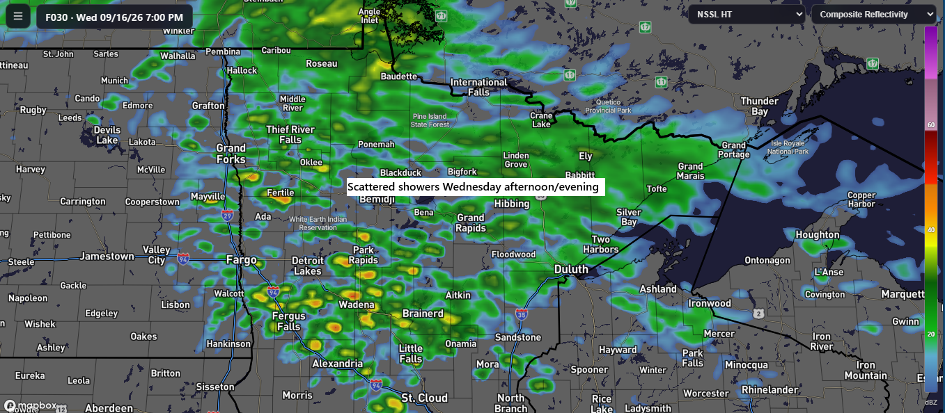
Scattered showers may occur across the Northland Wednesday afternoon and evening, though rainfall amounts are expected to be light.

After Monday’s rainfall in Duluth, here’s the latest update on precipitation statistics.
Month to date
Total: 3.15″
Departure: +1.37″
Since January 1
Total: 22.71″
Departure: -0.43″
While precipitation in Duluth for 2026 is close to normal, other parts of the Northland are experiencing significant deficits, with Brainerd, MN, down more than 9 inches and Ashland, WI, over 11 inches below average.

So far this month, Duluth, MN, has experienced eight separate rainfall events, with five surpassing a quarter-inch in accumulation.

It was a blustery Tuesday in the Northland, with westerly winds gusting between 15 and 30 mph, and occasional stronger gusts reaching 40 mph or more through mid-afternoon.
Even stronger winds were recorded over the Keweenaw Peninsula in upper Michigan, with gusts reaching 50 to nearly 60 mph today.
The RTMA model recorded wind gusts between 7 AM and 4 PM on Tuesday, September 15, 2026.
The windy conditions today were partly caused by a strong system rapidly moving northeast from Ontario into Hudson Bay, Canada.
Goes-19 water vapor loop covering 11:25 AM to 5:15 PM CT on Tuesday, September 15, 2026.
As winds ease tonight, temperatures will drop into the 40s across much of the Northland, with slightly milder conditions near Lake Superior.
Early Wednesday morning, patchy frost is possible, especially in far northern Minnesota, along with areas of fog across much of the Northland.

Fall and summer temperatures are both represented on today’s map, with temperatures ranging from 61°F in Duluth, MN, to 101°F in Oklahoma City, OK.

Here’s the next system that could eventually impact the Northland, currently moving across the Pacific Northwest.
Goes-19 water vapor loop from Tuesday, September 15, 2026, covering 11:25 AM to 5:15 PM CT.
The system over the Pacific Northwest is expected to move much more slowly than recent systems. If this energy impacts the Northland, it likely won’t arrive until early next week, based on current forecasts.
A lead disturbance over the western High Plains, highlighted in red on the map, will move northeast from Friday into early Saturday. However, it is uncertain how much, if any, rain this system will bring to our area.

Rainfall from Friday through early Saturday is expected to vary sharply from north to south. It remains uncertain whether areas north of the black line on the map will see significant rain, as some models predict little to no precipitation, while others suggest rain could reach as far north as Duluth, the North Shore, and the Iron Range.

Leave a Reply