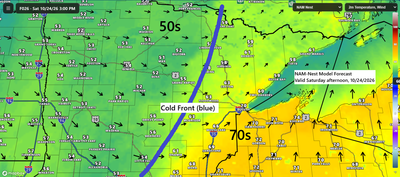
A cold front will move across the Northland Saturday afternoon into early evening, bringing scattered showers. Highs ahead of the front will reach the mid 60s to mid 70s across eastern Minnesota, the Twin Ports, and northwest Wisconsin, with cooler 50s following behind it across northern Minnesota.
Sunday’s highs will be in the upper 40s to 50s across northeast Minnesota and northwest Wisconsin, with no indication from computer models of prolonged cold weather at least through Halloween weekend. There’s still a possibility that Duluth could experience its first 32-degree low sometime next week, though those chances seem to be decreasing.
Record high temperatures for October 24
Ashland, WI: 79 set in 1963
Duluth, MN: 71 set in 1998
Note: Duluth could potentially tie or surpass a record high temperature Saturday.
In Duluth, there may be a few showers tonight and again Saturday afternoon, but neither round is expected to bring much rain, with totals likely around 0.05 to 0.2 inches.
NAM-Nest model simulated radar forecast through 11 PM Saturday.
NAM Nest model total precipitation through 11 PM Saturday.

…Fog Trends…
The fog in the Twin Ports area should start to clear tonight, though it may take some time. Foggy conditions are expected to linger into early Saturday morning along the North Shore of Lake Superior.
The HRRR model’s visibility forecast for late tonight is displayed below.

…Today’s weather 10/23/2026…
Showers and a few isolated thunderstorms have been passing through parts of western, central, and southern Minnesota today, moving toward the north-northeast. Out west, snow is falling in portions of western Montana, but the Northland won’t be seeing any snow anytime soon.
The MRMS radar loop from Friday, October 23, 2026, wraps up at 5:28 PM CT.
Today, a large system spans the western U.S. and parts of western Canada. One part of this system’s energy will move northeast into the upper Midwest through Saturday, while another part digs into the southwest U.S. before heading northeast into the upper Midwest early to mid next week.
GOES-East water vapor loop from Friday, October 23, 2026, ending at 5:25 PM CT.
High temperatures, deviations from the norm, and the record high for October 23.
Brainerd, MN
High: 75
Departure: +23 degrees
Record high: 76 set in 1901 and 1989
International Falls, MN
High: 75
Departure: +28 degrees
Record high: 78 set in 1963
Hibbing, MN
High: 73
Departure: +26 degrees
Record high: 79 set in 1963
A few things stood out on the temperature map this afternoon. One was a pocket of cooler temperatures from passing rain showers in west central Minnesota, and another was the cooler northeast flow off Lake Superior, bringing fog and patchy drizzle with temperatures in the upper 40s and 50s. In between these areas, conditions were unusually mild for late October, with temperatures in the 70s.

Leave a Reply