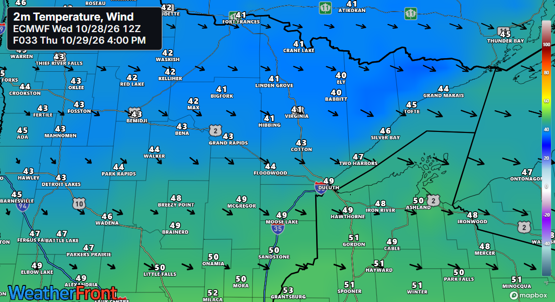
Typical highs for October 29th in the Northland are in the mid to upper 40s, and Thursday’s temperatures will be right around those numbers. It’ll also be breezy after tonight’s system, with northwest winds picking up between 15 and 25 mph.
Forecast models continue to show little evidence of any sustained outbreaks of cold air across northeast Minnesota and northwest Wisconsin through at least mid-November. Instead, several more mild days appear likely, with afternoon highs reaching the 50s and perhaps even touching the 60s at times over the next week or so.
Euro ensemble model temperature anomaly forecast through November 12, 2026.
In the loop below, orange and red colors represent above-average temperatures, while blue colors signify below-average temperatures.

A low-pressure system around 1010mb/29.83 inches over southwest Minnesota this afternoon will move quickly northeast, passing north of Lake Superior overnight. It will bring showers and some thunderstorms to northeast and eastern Minnesota into northwest Wisconsin for a few more hours this evening. Heavy downpours are expected, along with a continued threat of strong to severe storms until about 9 PM, mainly in northwest Wisconsin, with potential hail up to 1.25 inches in diameter (half dollar size) and winds of 40-60 mph.
It’s a classic fall weather setup, with warm air on one side of the low bringing afternoon temperatures in the 60s and low 70s, while cooler 40s settle in behind the low across parts of North Dakota today.

Rain in the Twin Ports is expected to taper off around 7 PM this evening.
MRMS radar loop ending at 5:12 PM CT on Wednesday, October 28, 2026.
The 700mb trough will move quickly to the northeast this evening, boosting atmospheric lift as it passes through the region.

Blend of models total rainfall through midnight tonight.

Thunderstorms popped up quickly around noon today in southwest Minnesota, near the Marshall and Willmar areas, and have been spreading and moving northeast through the afternoon. The yellow, orange, and red colors indicate cloud top temperatures ranging from about -55 to -65°C.
GOES-East infrared satellite loop from Wednesday, October 28, 2026, ending at 4:50 PM CT.
GOES-East water vapor loop from Wednesday, October 28, 2026, ending at 4:30 PM CT.
This afternoon, a few hail cores popped up across parts of western and central Minnesota. Most of the hail was about quarter-sized or smaller (1″ diameter or less), but there was a report of 3″ diameter hail—larger than a baseball—just before 2 PM near Grove City, MN.
MRMS 6-hour hail swath ending 5 PM CT Wednesday, October 28, 2026.

After tonight, the weather should dry out for a few days. Although a few showers can’t be ruled out this weekend, there is still no strong or consistent signal for widespread rain. Early next week bears watching, though, as a larger system could spread rain across the Northland around Monday and Tuesday. Forecast confidence remains limited because the models differ significantly on the storm’s track.

Leave a Reply