Tag: enhanced risk
-

Strong to Severe Thunderstorms still expected late this afternoon/evening over parts of the Northland – Updated 3 PM 7/28/2021
Conditions are still coming together for the potential of a higher end severe weather event from late this afternoon into this evening, primarily over far eastern Minnesota into parts of northwest Wisconsin. Primary severe weather hazards include large hail of golf ball to baseball size (1.75″ to 2.75″ in diameter)…
-

Strong to Severe Thunderstorms likely over parts of the Northland today (Wednesday) Updated outlook
Conditions appear to be coming together for a higher end severe weather day across the Northland, but especially from far eastern Minnesota into northwest Wisconsin. Stay Weather Aware today! Note: Multiple rounds of storms could impact some parts of the Northland through this evening. Severe thunderstorms capable of producing widespread…
-
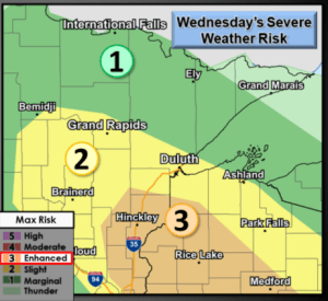
Strong to Severe Thunderstorms possible in parts of the Northland Wednesday
Another round of scattered strong to severe thunderstorms is possible across northeast Minnesota and northwest Wisconsin from Wednesday afternoon into Wednesday evening. The greatest chance for severe weather (Enhanced risk, orange area on map) stretches from eastern Minnesota into much of west-central Wisconsin, or roughly along and south of a…
-
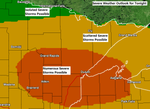
Strong to Severe Thunderstorms possible tonight (highest chances across southern portions of the Northland)
Strong to severe thunderstorms are possible across much of the Northland tonight, with an Enhanced Risk (3) for severe thunderstorms covering portions of northeast and east-central Minnesota and much of northwest Wisconsin (area in orange on map) while a Slight Risk (2) for severe thunderstorms covers areas farther north and…
-
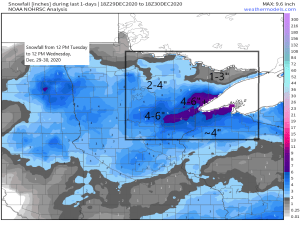
Northland Snowfall Totals from December 29-30, 2020; Gusty Winds possible along the North Shore tonight; mainly dry through this weekend
Last night’s snow event was an overachiever in some parts of the Northland, this was especially true near Lake Superior where widespread 5-6″+ snow totals were reported, including nearly a foot of snow near Cornucopia, and nearly 8″ of snow reported in the Two Harbors area. Totals in Duluth were…
-
Some rain tonight and Thursday morning; a risk for strong to severe storms Thursday night and Friday; cooler risks next week
A pesky MCV or Mesoscale Convective Vortex has been holding together nicely as it moves east across western and central Minnesota today. This feature has already brought some rain to southern portions of the Northland today, mainly around the Brainerd lakes and Aitkin areas. This disturbance will continue to affect…
-

Another round of thunderstorms possible late this afternoon/this evening, a few could be strong to severe
1:32 PM CT – There is an Enhanced Risk for Severe Thunderstorms late this afternoon into this evening over eastern Minnesota and for parts of northwest Wisconsin, roughly from Aitkin to Mahtowa, east to Lake Nebagamon, then south to Cable and Winter, this includes the Hayward lakes area as well.…