Tag: ice reports
-
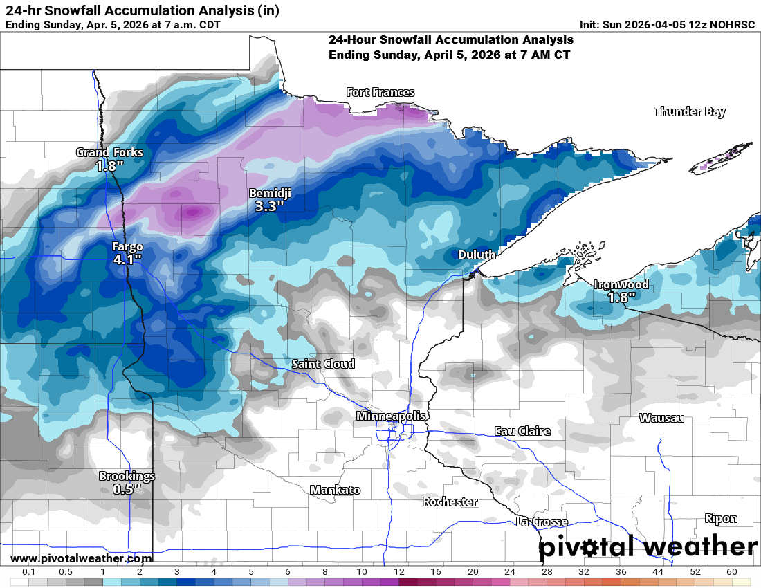
Snowfall and ice accumulation reports for April 3–4, 2026
Snowfall reports from Friday night to Saturday, April 3–4, 2026 Note: The snowfall total for the 2025-2026 season in Duluth has reached 82.2 inches, just 0.1-inch shy of the normal amount to date, which is 82.3 inches. Ice accumulation reports from the early hours of Saturday morning, April 4, 2026.…
-

Top 10 Driest Years for Duluth, MN
2025 could turn out to be one of the top 10 driest years on record for Duluth, Minnesota. As of December 25th, 20.09 inches of precipitation have fallen this year, which is 10.83 inches less than the normal total of 27.33 inches. The ten driest years on record in Duluth,…
-
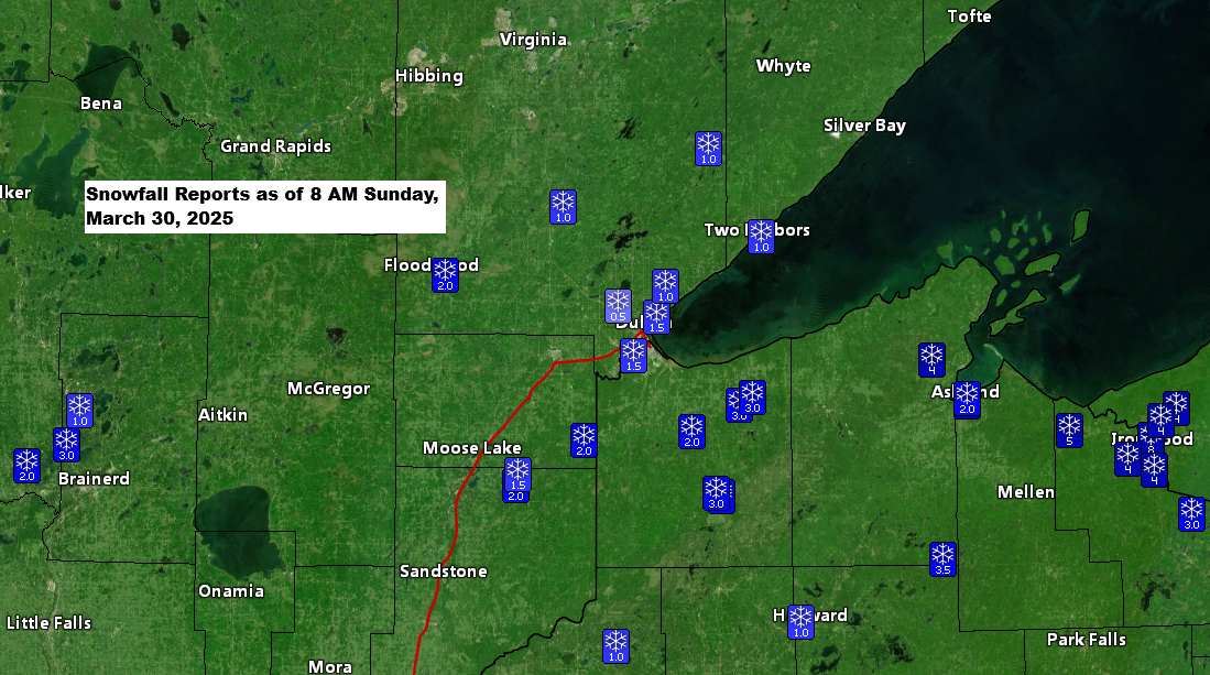
Snowfall and Ice Reports for the Northland
9:50 AM Sunday, March 30, 2025 Snowfall Reports as of 9 AM Sunday, March 30, 2025 Ashland, WI: 5.3″2 N Moquah, WI: 5.0″4 NW Namekagon, WI: 4.8″6 W Washburn, WI: 4.5″3 WNW Clam Lake, WI: 3.8″Solon Springs, WI: 3.5″1 WSW Maple, WI: 3.4″4 S Nisswa, MN: 3.3″1 ENE Maple, WI:…
-
Snowfall and Freezing Rain (Ice) totals thru 8 PM Thursday
8:31 PM Thursday, April 20, 2023 Snowfall Reports from April 20, 2023Source: National Weather Service Duluth, Minnesota Note — Totals below are thru around 8 PM Thursday, April 20, 2023 Hovland, MN: 8.0″8 W Hovland, MN: 7.5″12 N Grand Rapids, MN: 5.0″1 SSE Hibbing, MN: 4.8″1 WNW Brainerd, MN: 4.8″2…
-

Thursday afternoon Winter Storm and Power Outage Update; Lakeshore Flood Warning issued
1:48 PM Thursday, April 20, 2023 Snowfall Reports from April 20, 2023Source: National Weather Service Duluth, Minnesota 8 W Hovland, MN: 6.5″Silver Bay, MN: 4.3″3 SE Finland, MN: 3.5″2 SSW Ely, MN: 2.6″3 WSW Shaw, MN: 2.0″Duluth, MN: 2.0″ (Official total at the National Weather Service thru 5 AM) 1…
-

One system exits tonight, the next one arrives late Tuesday night-Wednesday; More snow chances late this weekend-early next week; Severe weather outbreak possible late this week across parts of the southern/southeast US; Ice and Snowfall Reports from today
6:14 PM Monday, February 27, 2023 A brief break in the active weather occurs on Tuesday with some sun expected, but another fast-moving system moves this way out of the Northern Rockies late Tuesday night into Wednesday and this one will be a colder system meaning that precipitation will be…
-
Lake Effect Snow this weekend for the South Shore of Lake Superior with scattered flurries/snow showers elsewhere; Accumulating snow possible early to mid-next week; Cold pattern through next week
5:12 PM Friday, November 11, 2022 Lake effect snow is likely through Saturday night along the South Shore of Lake Superior in northwest Wisconsin with scattered flurries and snow showers possible elsewhere in the Northland, but the most significant snow amounts tonight and Saturday will certainly be downwind of Lake…