Tag: park point
-

Winter Storm wraps up tonight; Keeping an eye on a late week system which could bring more snow or a mix along with some wind to parts of the Northland
6:33 PM Sunday, March 12, 2023 We’re finally seeing the surface and upper-level low responsible in bringing the heavy snow to parts of the Northland this weekend start to pull away from the Northland late this afternoon and this trend will continue tonight. Snow will linger this evening in parts…
-

More rain and wind through Sunday, strongest winds near Lake Superior; Flood warning/watch in effect for parts of the Northland; April 2022 wettest April on record at International Falls; A stretch of dry weather ahead after Sunday
7:47 PM Saturday, April 30, 2022 Strong northeasterly winds will continue near Lake Superior and in the Twin Ports tonight into Sunday morning with diminishing wind speeds Sunday afternoon, but until then expect wind gusts of 25 to 45 mph to continue. Occasional rain and drizzle through Sunday evening with…
-
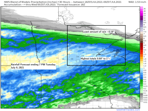
Rain and much cooler temperatures on the way for Tuesday; Dry pattern returns after Tuesday with milder temps late this week
A big drop in temperatures is coming on Tuesday – Check out the temperature forecast from the 18z NAM 3km model valid from Midnight tonight to 7 PM Tuesday. Overnight temps in the 60s to lower 70s tonight, and then will see falling temperatures during the day Tuesday, in fact…
-
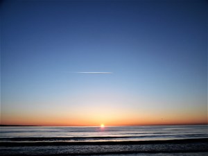
Sunrise over Lake Superior
A cold, but beautiful sunrise over southwest Lake Superior this morning, Sunday, April 25, 2021. Duluth, Minnesota, Park Point, Lake Superior. Note: We’re quickly approaching sunrise times of before 6 AM in Duluth, those will begin on April 27th and will continue through August 10th, sunrise times during that period…
-
Warm temperatures continue into midweek; keeping an eye on thunderstorm chances Wednesday afternoon/night and cooler risks for next week
We’ve seen a few showers and thunderstorms develop this afternoon over far eastern Minnesota and northwest Wisconsin with brief downpours and some lightning occurring with this activity today – Radar Rainfall Estimates thru 4 PM Monday show anywhere from a trace to nearly a half inch of rain with those…
-
Nice weather continues through Wednesday; Rain chances Thursday-Friday with cooler temperatures. 60-day Northland rainfall totals in this post, some locations have picked up over 16" of rain since mid May
/Issued 7:35 PM CDT, Monday, July 16, 2018/ Source: https://lab.weathermodels.com Total Rainfall Map for the 60-day period from May 17 to July 16, 2018 Rainfall totals have been well above average in most of northeast Minnesota and northwest Wisconsin since mid May, but the extreme northeast portion of Minnesota around the…
-
Beautiful tonight; Isolated showers possible Tuesday; Scattered showers/t-storms early Wed AM; Potential for heavy rain, flooding and strong to severe t-storms Wed night-early Thu AM
/Issued 4:27 PM CDT, Monday, July 9, 2018/ Source: http://www.wpc.ncep.noaa.gov Potential for strong to severe thunderstorms returns to the Northland on Wednesday, especially for Wednesday night-early Thursday morning the way it looks now. Could see a bow echo of some sort move south/east out of Ontario Province or northwest Minnesota late…