Tag: Record Warmth
-

Warm weather continues this week (cooler at times near Lake Superior) A few showers/t-storms possible, but a lot of us stay dry thru midweek
A very warm weather pattern lingers this week with daytime highs in the Northland in the 80s to lower 90s, but we will have some days which will have an easterly wind, and when that happens, temperatures will be a lot cooler within about 10 to 15 miles of Lake…
-
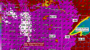
Record/Near Record Warmth on the way through Sunday; cooler lake breezes at times closer to Lake Superior; a few showers/t-storms possible this weekend
…Record Highs likely to be broken in the Northland on Friday… Here are the record high temperatures for June 4th Ashland, WI: 92 set in 1968 International Falls, MN: 92 set in 1988 Duluth, MN: 90 set in 1968 Brainerd, MN: 89 set in 1988 Hibbing, MN: 88 set in…
-
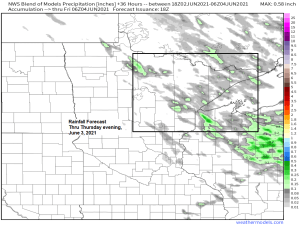
A few showers possible tonight and Thursday; turning hot Friday through Sunday, but much cooler near Lake Superior on Friday
Some parts of the Northland will likely get a little rain at times tonight and during the day Thursday (see sim radar forecast below) as we remain under a northwest flow aloft. Isolated thunderstorms are possible as well mainly on Thursday, but the amount of instability, moisture and wind shear…
-

Cooler temperatures this week; some rain possible Monday (rain/snow mix in the Arrowhead)
We’ve got a little rain in the forecast for parts of the Northland on Monday, and there is even a chance that the rain could mix with some snow Monday night-Tuesday morning over the Arrowhead of Minnesota (north of Duluth) but little if any snow accumulation is expected at this…
-

Isolated strong to severe thunderstorms possible in parts of the Northland late Monday afternoon/evening
A large portion of the Northland is in a Marginal Risk (green shaded area on map) for severe thunderstorms on Monday. It’s a 1/5 risk (lowest risk on the 5 point scale) but still stay weather aware especially in the afternoon and evening when we could see a few thunderstorms…
-

A windy, wet storm on the way; 30-35+ mph NE winds near Lake Superior Tuesday PM-Wednesday AM; some light rain arrives Tuesday, heavier rain Tuesday night, rain could mix with/change to snow in parts of the Northland Tuesday night-Wednesday
A strong spring storm will be impacting a large portion of the Northland the next few days Some light rain lifts north into east-central Minnesota and northwest Wisconsin on Tuesday while it stays dry across northern Minnesota. Heavier and more widespread precipitation arrives late Tuesday afternoon or Tuesday evening, and…
-

A little rain tonight; cooler but still above normal temps Monday; rainy Tuesday-Wednesday (some wet snow in northern Minnesota)
We’ve got some rain in the forecast for northeast Minnesota and northwest Wisconsin tonight into early Monday morning as a cold front moves east and through the area. Visible satellite loop from today, Sunday, March 21, 2021 showing the thicker cloud cover associated with an eastward moving cold front moving…