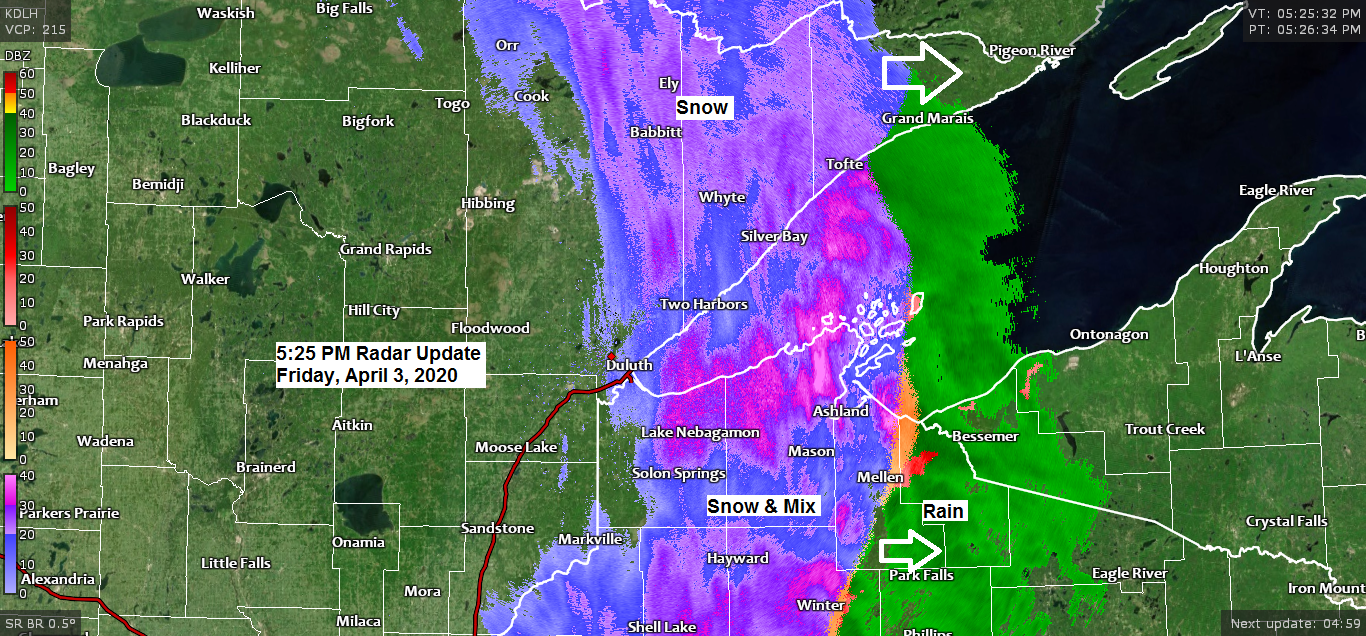
-Winter Weather Advisory remains in effect until 9 PM this evening for parts of northeast Minnesota and northwest Wisconsin (purple shaded area on map) Some cities included in the advisory are Grand Marais, Isbella, Silver Bay, Two Harbors, Superior, Solon Springs, Port Wing, Washburn, Bayfield, Minong, Siren and Hayward.
-A wintry mix of snow, sleet and patchy freezing rain will continue this evening with ice accumulations of a light glaze and snow accumulations of a dusting to 2 inches.
-Plan on slippery road conditions.
Source: https://www.weather.gov/dlh/

This has been quite a cold front this week! It’s a Blue Norther!
Check out this temperature contrast from this afternoon.
Soure: RTMA model; https://lab.weathermodels.com/

Temperatures are running 30 to over 40 degrees colder this afternoon compared to 24-hours ago from parts of the Southern Plains to the upper Midwest (purple colors on map)
Source: RTMA model

A strong baroclinic zone has moved a little farther east today into western Wisconsin, but it won’t move much farther to the east.
Source: RAP model; https://www.spc.noaa.gov/

Low temperature forecast for Saturday morning, April 4, 2020. Source: https://lab.weathermodels.com/

High temperature forecast for Saturday, April 4, 2020.

There continues to be a chance for some thunderstorms early next week as instability increases while a plume of steep mid level lapse rates advects ENE into the upper Midwest. Still some uncertainty on the timing of this next system for early next week, and where the instability gradient and warm frontal boundary sets up, but there is at least some threat for thunderstorms in the Northland, especially for east-central Minnesota and northwest Wisconsin early next week. Stay tuned.
Source: 12z European computer model 4.3.2020; https://weathermodels.com/

| 24 Hour Precipitation Reports from around the Northland Period: 4 PM Thursday to 4 PM Friday, April 2-3, 2020 Source: https://mesowest.utah.edu/ Orr, MN: 0.47″ Silver Bay, MN: 0.38″ Pine River, MN: 0.32″ McGregor, MN: 0.31″ Chisholm-Hibbing Airport: 0.29″ International Falls, MN: 0.29″ Grand Rapids, MN: 0.27″ Hayward, WI: 0.27″ Hill City, MN: 0.26″ Ashland, WI: 0.25″ Littlefork, MN: 0.23″ Bigfork: 0.21″ Washburn, WI: 0.19″ Cass Lake, MN: 0.18″ Solon Springs, WI: 0.18″ Minong, WI: 0.18″ Clam Lake, WI: 0.17″ Moose Lake, MN: 0.16″ Siren, WI: 0.16″ Walker, MN: 0.15″ Duluth Airport: 0.14″ Ely, MN: 0.13″ Superior Airport: 0.08″ |
…Weather Summary…
A wintry mix of snow, sleet and patchy freezing rain continues early this evening in far northeast Minnesota and northwest Wisconsin, but this precipitation will diminish from SW-NE through the evening with dry conditions forecast for the overnight with clearing skies.
Note: A few snowfall reports through 5 PM Friday include 1.5″ at McKinley, MN; 0.5″ near Iron Junction, MN; 0.3″ at Cloquet.
It will be a chilly night with lows in the single digits and teens with northwest winds 10 to around 20 mph.
Lots of sunshine for Saturday with highs in the upper 30s to lower 40s. Winds will be out of the northwest, becoming southwest for some, wind speeds of 10 to 20 mph.
Partly to mostly cloudy skies on Sunday. Even milder with highs in the upper 40s to middle 50s.
Rain chances return in the Sunday night to Tuesday time frame, and a few thunderstorms are possible as well especially Monday night and Tuesday.
Forecast for Duluth and Superior
.Tonight… Flurries and patchy freezing drizzle early followed by decreasing cloudiness overnight. Low 13 to 18. Wind northwest 10 to 20 mph.
.Saturday… Mostly sunny. High 40 to 45. Wind west to northwest 10 to 20 mph.
.Sunday… Partly cloudy. High 48 to 53. Wind south to southwest 10 to 20 mph.
| Normal temperatures for April 4 High 43 Low 25 Sunrise Saturday 6:41 AM CDT Sunset Saturday 7:43 PM CDT |
Thanks for reading!
Tim
Leave a Reply