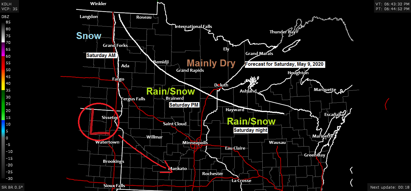
-Some rain and snow is possible Saturday into Saturday night mainly affecting southern portions of the Northland. This area of precipitation should stay south of Duluth and Superior, but there is some uncertainty on how far north the precipitation will reach as the latest NAM run (18z) shifted this band of precipitation farther north with it impacting the Twin Ports Saturday evening with some light snow accumulations, but the most likely scenario is for this rain and snow to remain south of Duluth and Superior.
-Otherwise for Saturday we’re looking at continued cool temperatures with partly sunny to mostly cloudy skies. Temperatures at daybreak are forecast to be in the 20s to lower 30s with generally light winds out of the northwest <12 mph. Temps Saturday afternoon are forecast to be in the 40s to lower 50s, but where precipitation falls, temps will be cooler in the 30s. Winds for Saturday afternoon out of the north, northeast or northwest at 10 to 20 mph.
Here’s my snowfall accumulation forecast for Saturday’s event.
Note: Snow totals should generally be around a trace to a half-inch from the Brainerd Lakes to Hinckley, east to Hayward as some of the precipitation falls as rain or a rain-snow mix, but heavier precipitation rates are possible which would cause dynamic cooling and a better chance for all snow along with bursts of heavier snow. Timing of this looks to be from Saturday afternoon into Saturday night spreading and also ending from NW-SE.

Widespread Freeze Warnings in effect (dark blue area on map) and even a Winter Weather Advisory for accumulating snow in parts of northern/eastern North Dakota (purple area on map)
Source: https://www.pivotalweather.com/

Strong upper low over eastern Canada today while a rather vigorous system heads S-SE across Saskatchewan Province, this is the system that will move through the Northern Plains and upper Midwest on Saturday. Strong lift with this feature will cause precipitation to break out across parts of the Dakotas, southeast into parts of Minnesota and Wisconsin for Saturday and Saturday night.
Source: Goes-16 water vapor imagery https://weather.cod.edu/5.8.2020;

An unusually strong upper level low has moved into eastern Canada today with 500mb heights as low as 522 meters!
A widespread cold air mass covered much of central/eastern Canada, south to the upper Midwest, Great Lakes, midwest and northeast US today.

Check out these temperatures from late Friday afternoon, May 8th, 2020.
Note: High temperatures across the Northland are running some 15 to 20 degrees below normal for May 8th, but not quite cold enough to break the record cold high temps which were in the mid 30s to around 40 degrees on today’s date (May 8th)

The Northland will remain in a cool weather pattern through most of next week, but big changes continue to show up in model guidance starting ~May 16th and beyond.
Source: 12z European ensemble model 5.8.2020; https://weathermodels.com/

A pattern change featuring troughing over the western US and ridging across the Plains is showing up in computer models mid to late month, this pattern could bring more persistent warmth to the upper Midwest, but could also cause more frequent rain events.
Source: 12z European ensemble model 5.8.2020

Note: Last year on today’s date (May 8th) parts of the Northland saw significant amounts of snow.
The Duluth Airport picked up 8.3″ of snow on May 8th, and another 2.3″ of snow on May 9th for a storm total of 10.6″!
Thunder Snow even occurred in Duluth with this May snowstorm!
Here’s a look back at the winter weather headlines and a radar image from May 8th, 2019.


Forecast for Duluth and Superior
.Tonight… Partly cloudy. Low 28 to 33. Wind northwest 5 to 15 mph.
.Saturday… Partly to mostly cloudy. High 47 to 52. Wind west to northwest 10 to 15 mph becoming north late.
.Sunday… Partly sunny. High 45 to 50. Wind north 10 to 20 mph.
| Normal temperatures for May 9 High 60 Low 39 Records for May 9 High 88 degrees set in 1896 Low 20 degrees set in 1966 Sunrise Saturday 5:41 AM CDT Sunset Saturday 8:30 PM CDT |
Thanks for reading!
Tim
Leave a Reply