6:38 PM Tuesday, April 23, 2024
An active weather pattern is expected to develop later this week and persist into the following week.
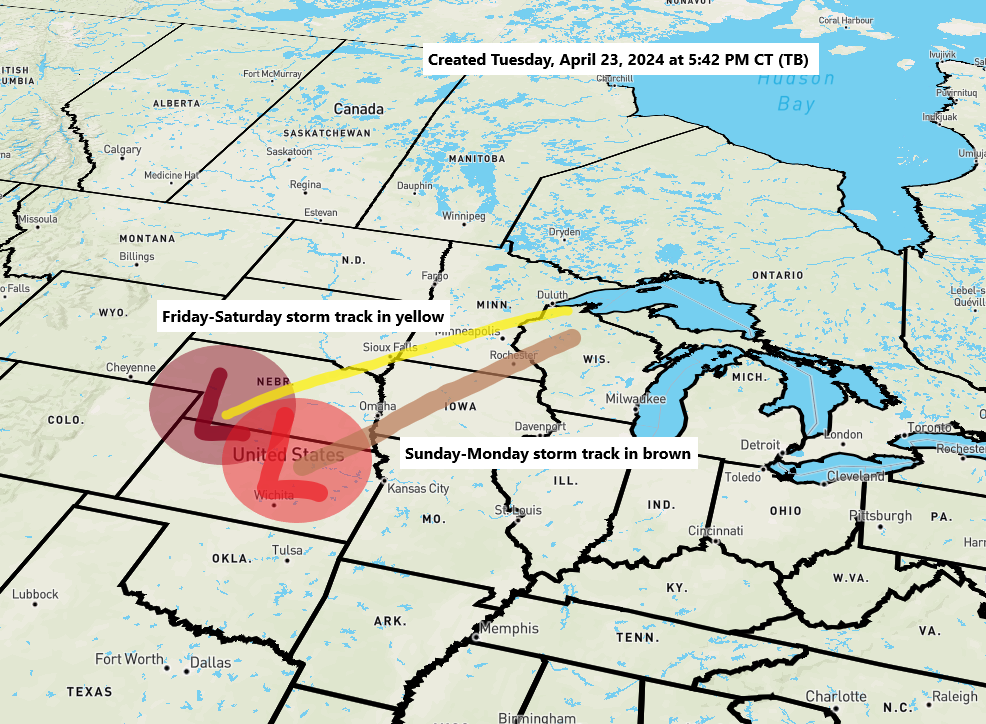
The Northland will experience two low-pressure systems from Friday to Monday. The first system is expected to arrive Friday and continue into Saturday morning, followed by a respite Saturday afternoon and night. A second system is forecasted to approach from the south on Sunday, potentially persisting into Monday.
In these two systems alone, there’s a likelihood that a significant portion of the Northland could receive an inch or more of rain, with the far northern regions of Minnesota potentially experiencing slightly lower totals into the early part of next week.
Severe thunderstorms, with a risk of tornadoes, are expected daily starting Thursday due to warmer air in the central and southern Plains. While severe thunderstorms are not anticipated in the Northland through early next week, occasional embedded non-severe thunderstorms may occur.
There is a possibility that warmer and more unstable air may shift further north, potentially escalating the risk of severe thunderstorms in parts of the Northland. This event could happen from the middle to the end of next week, as computer models suggest a significant northward movement of warm, humid, and unstable air into our region.
This is an overview of the potential rainfall amounts through the upcoming Monday, as predicted by the NWS Blend of Models.

Rain will spread northward across Northland throughout Friday.
European model simulated radar forecast valid 1 AM Friday to 1 AM Saturday.

The upcoming weekend weather system is expected to present a significant temperature gradient, with potential temperatures in the 30s near Lake Superior, including Duluth, and reaching into the lower 70s in southern Minnesota.
Note: While the second system arriving late this weekend appears to be a colder one for the Northland, the temperatures seem unlikely to be low enough for snow to occur instead of rain, though it could be a close call in certain areas.

Today, a cold front passing through the Northland triggered several thunderstorms in east central Minnesota and northwest Wisconsin. Duluth notably marked its first thunder day of 2024 this afternoon.
Areas around Lake Superior experienced a significant temperature shift this afternoon due to a potent cold front that traveled southward across the region today.
At 4 PM today (Tuesday), temperatures near Lake Superior were between -20 and -30 degrees colder than at the same time on Monday.

Temperatures that were in the 50s in Duluth earlier this afternoon have dropped to the upper 30s later in the day, with similar conditions in the 30s prevailing across much of northwest Wisconsin, as well as in the Arrowhead and North Shore regions.
This afternoon, milder temperatures ranging from the low to mid-50s persisted further inland in North Central Minnesota.
Note: Today, Tuesday, April 23rd, Duluth experienced its 8th consecutive day of peak wind gusts reaching at least 30 mph. This pattern is expected to break on Wednesday with calmer winds forecasted. However, another bout of strong northeast winds is anticipated later this week and into the next, with Sunday potentially bringing gales to western Lake Superior and the possibility of wind gusts exceeding 40 mph in the Twin Ports area.
This month, Duluth has experienced 16 days with peak wind gusts reaching at least 30 mph.

The coming days bring the possibility of severe thunderstorms across the central and southern Plains.
From Thursday to Sunday, all severe hazards, including large hail, damaging winds, and potential tornadoes, are possible.
The map below indicates an Enhanced Risk (Level 3/5) of severe thunderstorms for Thursday in the area highlighted in orange.


24-Hour Rainfall Reports for April 22-23, 2024
Source: MesoWest
Totals below are through 6:31 PM Tuesday.
The Bay of Grand Marais, MN: 0.30″
Isabella, MN: 0.22″
Minong, WI: 0.15″
Esko, MN: 0.14″
Danbury, WI: 0.11″
Poplar, WI: 0.09″
Spooner, WI: 0.08″
Littlefork, MN: 0.07″
Ashland, WI: 0.06″
International Falls, MN: 0.06″
Solon Springs, WI: 0.05″
Duluth Airport: 0.04″
Hinckley, MN: 0.04″
Orr, MN: 0.04″
Saginaw, MN: 0.03″
Hill City, MN: 0.03″
Hayward, WI: 0.02″
Siren, WI: 0.02″
Cass Lake, MN: 0.02″
Eveleth-Virginia, MN: 0.02″
Ely, MN: 0.02″
McGregor, MN: 0.01″
Thanks for reading!
Tim
Leave a Reply