6:22 PM Thursday, April 25, 2024
The calm weather we’ve experienced over the past few days is expected to change on Friday with the arrival of the first of two troughs or low-pressure systems moving out of the Rockies.
Rain is expected in the Northland from Friday through Saturday afternoon, with the precipitation moving north/east into our region throughout Friday.
A pause in the rainfall is anticipated later on Saturday, extending into early Sunday morning, with a likelihood of more rain from Sunday into Monday morning.
There’s a possibility of snow or a rain-snow mixture from Sunday night to early Monday morning, primarily in the far northern region of Minnesota near International Falls. However, minimal snow accumulation is anticipated.

The storm tracks for both systems in the coming days are quite similar, with Sunday’s system potentially veering a bit more to the south/east. However, both lows are expected to pass to the south/east of Duluth, which will keep us on the cooler side of these systems.

There are still discrepancies in the computer models concerning the timing of rain in Duluth on Friday. However, the likelihood of rain is expected to rise, particularly into Friday afternoon and evening. A wet late Friday night and Saturday morning appear quite probable, but the rain should taper off by mid to late Saturday afternoon.
NAM 3km model simulated radar forecast valid 7 AM Friday to 7 PM Saturday.

Precipitation anomalies in Northland for April 2024, up to 4 PM on the 25th.
Duluth, MN: -0.83″ below normal
International Falls, MN: -0.80″ below normal
Ashland, WI: -0.67″ below normal
Hibbing, MN: -0.01″ below normal
Note: Brainerd is currently +0.42 inches above the normal average for the month.
The Northland is forecasted to receive widespread rainfall, with totals exceeding an inch, from Friday through Monday. This should eliminate most, if not all, of the deficits currently observed across much of the Northland this month.

There remains a possibility of experiencing some thunderstorms in parts of Northland on Friday afternoon and evening due to elevated instability moving north from southern Minnesota. However, severe weather is not anticipated in our area on Friday.

The weather system on Sunday appears to be colder than Friday’s. In fact, there could be sufficient dynamic cooling for the precipitation to transition from rain to snow, or for a mix of rain and snow, in far northern Minnesota from Sunday night into early Monday morning.

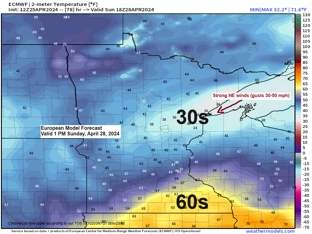
On Friday, expect the northeast winds to intensify near Lake Superior, including Duluth, with gusts reaching approximately 30 mph. These gusty conditions are anticipated to persist into Saturday morning.
On Sunday, even stronger northeast winds may occur as a second low-pressure system approaches from the south. Wind gusts around Lake Superior, including the Twin Ports area, could reach 35 to 50 mph from Sunday into Monday morning.
European model wind gust forecast valid 7 AM Sunday to 7 AM Monday.

Today’s spring temperatures displayed a typical pattern, with cooler readings in the 40s and 50s near Lake Superior this afternoon. Meanwhile, milder temperatures in the 60s and 70s were prevalent to the west and south.

Today, there is an active period of severe thunderstorms, with a tornado watch issued for areas of northeast Colorado, southwest Nebraska, and northwest Kansas, effective until 9 PM this evening.

The likelihood of severe thunderstorms persists across a vast area of the central and southern Plains from Friday to Sunday.
The forecast includes all forms of severe weather hazards, such as large hail potentially reaching 3 inches in diameter, damaging winds, and several tornadoes, some of which may be intense.
The risk for severe thunderstorms on Friday is greatest in areas of eastern Nebraska, west-central Iowa, northeast Kansas, and northwest Missouri, which are under an Enhanced risk (level 3 out of 5) for severe weather, as indicated by the orange highlight on the map below.

The shaded region on the map indicates the potential for a few significant tornadoes (EF2 or greater) on Friday.

An enhanced risk (indicated by the orange area on the map) for severe thunderstorms is forecasted for parts of the central and southern Plains on Saturday. A slight risk (shown in yellow) extends as far north as eastern Wisconsin and western-northern Lower Michigan.

Sunday’s severe thunderstorm risk (yellow area on the map below)

Thanks for reading!
Tim
Leave a Reply