8:04 PM Sunday, May 11, 2025
International Falls reached a high of 95 today (May 11th), marking the first 90-degree day of the year, while the average date for the first 90 is June 24th. The earliest was April 21st in 1980.
The last time it reached 90 degrees or more in International Falls was June 20, 2023.
The record for the most 90-degree days in May at International Falls is 3 days, set in 1986, 1980, and 1919.
Record breaking warmth in the Northland today.
Here’s a look at the new record highs set for May 11th
International Falls, MN
New record: 95
Old record: 83 set in 1991 and 1993
Brainerd, MN
New record: 93
Old record: 92 set in 1900
Duluth, MN
New record: 87
Old record: 83 set in 1991
Ashland, WI
New record: 87
Old record: 85 set in 1991 and 1992
Both Duluth and International Falls have had 3 days this month with temperatures of 80°F or higher. Typically, Duluth averages 2 days and International Falls averages 3 days in May at that temperature. The record for the most days at or above 80°F in May is 16 days for International Falls, set in 1980, and 8 days for Duluth, set in 2018 and also in 1980.
Precipitation anomalies for May 2025 as of 4 PM on the 11th
Ashland, WI: -0.83″ below normal
Brainerd, MN: -0.72″ below normal
International Falls, MN: -0.48″ below normal
Duluth, MN: -0.30″ below normal
Hibbing, MN: -0.30″ below normal
Note: Since March 1st, Duluth is running -0.28″ below normal in precipitation.
Our precipitation deficits in Duluth aren’t overly extreme as of now, and assuming we do get into a wetter pattern later this week and beyond, then that should help. Plus, the green up is starting to accelerate now with these very warm temperatures.
Another hot one for Monday with widespread 80s and lower 90s across the Northland with cooler temperatures closer to Lake Superior especially along the North Shore.
Note: An east wind will likely develop in Duluth, especially on Tuesday and Wednesday, making those days cooler by the lake. However, Monday will probably be very warm as the winds continue to come from the south.
More record highs will likely be set across the Northland on Monday.

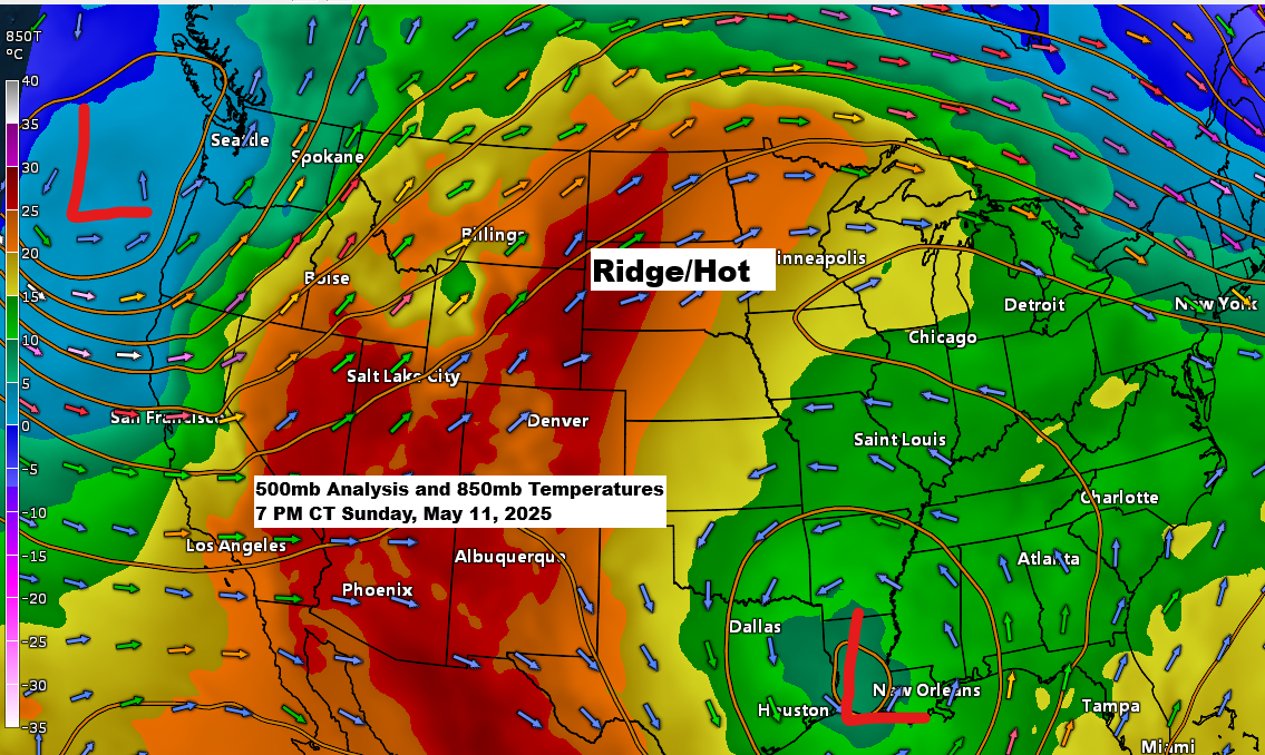
It’s hot in the northern Plains and upper Midwest today, and the same is expected for the next few days, but changes will come later this week.
Goes-16 water vapor loop ending 7:20 PM CT Sunday, May 11, 2025.

Rain chances rise in the Northland on Thursday as a strong low-pressure system moves in from the west/south. Thunderstorms are possible, but severe weather is unlikely in our area the way it looks now.
Additional chances for some scattered rain on Friday, and another system could bring some more rain to the Northland around May 18-20.
So, while it has been dry recently and will remain dry for the next few days, computer models suggest the pattern may become more active in the middle to late part of the month.

Rainfall of half an inch or more is possible late this week in northwest Wisconsin and northeast Minnesota, with over an inch possible in north central Minnesota.

Thanks for reading!
Leave a Reply