A low-pressure system over the Rockies this afternoon will move east across the central Plains from Monday into early Tuesday. Although it will remain well south of Minnesota, its northern edge will bring some precipitation into southern Minnesota late Monday afternoon through Tuesday morning. Expect a mix of rain and wet snow, with the chance for slushy accumulations in parts of southern Minnesota during this period.
No rain or snow is expected in northeast Minnesota or northwest Wisconsin on Monday or Tuesday, as this system will remain well to the south.

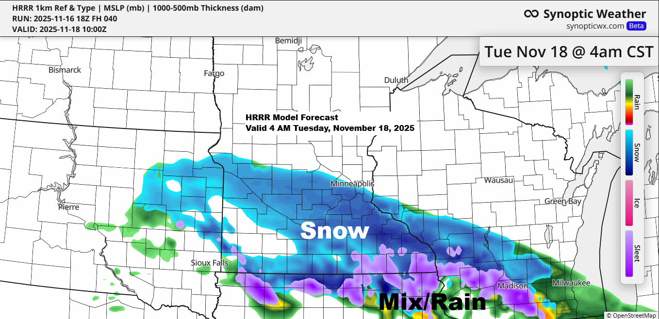
It looks like all the lift driving precipitation will stay over southern Minnesota and southern Wisconsin from late Monday afternoon through Tuesday morning.
NAM 500mb forecast valid 6 PM Monday to 6 AM Tuesday.

Rain is expected to move into southern Minnesota late Monday afternoon, eventually mixing with and turning to snow or a rain/snow mix by Monday night. This wintry mix will likely linger into Tuesday morning before tapering off by Tuesday afternoon.
HRRR model simulated radar forecast valid 2 PM Monday to 12 PM Tuesday.
Snow (blue)
Rain (green)
Mix (pink)

Temperatures Monday night in southern Minnesota and parts of southern Wisconsin look borderline for snow, but there should be enough cooling for some wet snow, with slushy accumulations of up to 2 inches possible in a small part of southern Minnesota. Elsewhere, snow totals are expected to stay under an inch.

Later this week, a northern clipper system will move southeast, bringing some rain and snow showers to northeast Minnesota and northwest Wisconsin from late Wednesday into Thursday, though only light precipitation is expected.
This clipper system should help prevent another weather system developing over the southern Rockies from making its way to the Northland later this week.

Over the next 7 days, through Sunday, November 23, 2025, none of the 20 GEFS ensemble members show any significant snowfall in Duluth.
Only 0.3 inches of snow have fallen so far this month in Duluth, which is -6.2 inches below normal to date.

Looking far ahead, more than 250 hours out, the GEFS model hints at a possible system moving across the Northland. Several ensemble members suggest there could be snow, rain, or a mix across northeast Minnesota and northwest Wisconsin on Thanksgiving (November 27).
The chances of this happening are pretty slim right now since it’s still a bit far off, but the week of Thanksgiving is worth watching in the coming days to see how the models shape up.
Snow – blue
Rain – green
Mix – pink

A colder weather pattern might set in during the last week of November and carry into early December, but since it’s still a ways off, things could change.
On the maps below, blue and purple indicate below-normal temperatures, while orange and red represent above-normal temperatures.
Right now, the GEFS (American ensemble model) and GEPS (Canadian ensemble model) are more aggressive in pushing colder air into the upper Midwest, while the EPS (European ensemble model) keeps the coldest air farther to the west.


Leave a Reply